concept EIA-rapport - Staatsolie
concept EIA-rapport - Staatsolie
concept EIA-rapport - Staatsolie

Create successful ePaper yourself
Turn your PDF publications into a flip-book with our unique Google optimized e-Paper software.
SRK Consulting: Project No: 439414 <strong>Staatsolie</strong> Pipeline <strong>EIA</strong> – Draft <strong>EIA</strong> Report Page 28<br />
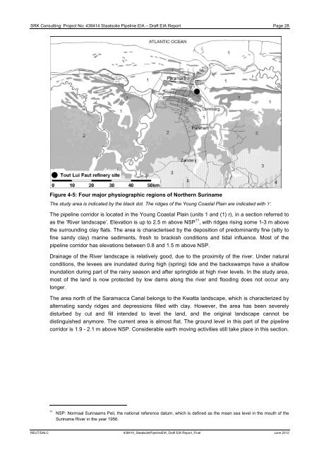
Figure 4-5: Four major physiographic regions of Northern Suriname<br />
The study area is indicated by the black dot. The ridges of the Young Coastal Plain are indicated with ‘r’.<br />
The pipeline corridor is located in the Young Coastal Plain (units 1 and (1) r), in a section referred to<br />
as the ‘River landscape’. Elevation is up to 2.5 m above NSP 11 , with ridges rising some 1-3 m above<br />
the surrounding clay flats. The area is characterised by the deposition of predominantly fine (silty to<br />
fine sandy clay) marine sediments, fresh to brackish conditions and tidal influence. Most of the<br />
pipeline corridor has elevations between 0.8 and 1.5 m above NSP.<br />
Drainage of the River landscape is relatively good, due to the proximity of the river. Under natural<br />
conditions, the levees are inundated during high (spring) tide and the backswamps have a shallow<br />
inundation during part of the rainy season and after springtide at high river levels. In the study area,<br />
most of the land is now protected by low dams along the river and flooding does not occur any<br />
longer.<br />
The area north of the Saramacca Canal belongs to the Kwatta landscape, which is characterized by<br />
alternating sandy ridges and depressions filled with clay. However, the area has been severely<br />
disturbed by cut and fill intended to level the land, and the original landscape cannot be<br />
distinguished anymore. The current area is almost flat. The ground level in this part of the pipeline<br />
corridor is 1.9 - 2.1 m above NSP. Considerable earth moving activities still take place in this section.<br />
11 NSP: Normaal Surinaams Peil, the national reference datum, which is defined as the mean sea level in the mouth of the<br />
Suriname River in the year 1956.<br />
REUT/DALC 439414_<strong>Staatsolie</strong>Pipeline<strong>EIA</strong>_Draft <strong>EIA</strong> Report_Final June 2012