concept EIA-rapport - Staatsolie
concept EIA-rapport - Staatsolie
concept EIA-rapport - Staatsolie

You also want an ePaper? Increase the reach of your titles
YUMPU automatically turns print PDFs into web optimized ePapers that Google loves.
SRK Consulting: <strong>Staatsolie</strong> Pipeline <strong>EIA</strong> – Draft <strong>EIA</strong> Report Summary Page iii<br />
• Identify measures to address the impacts assessed; and<br />
• Develop Management Plans, based in part on the<br />
mitigation measures developed in the <strong>EIA</strong> Report.<br />
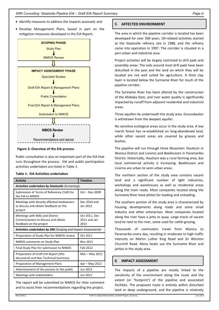
SCOPING PHASE<br />
Study Plan<br />
NIMOS Review<br />
IMPACT ASSESSMENT PHASE<br />
Specialist Studies<br />
Draft <strong>EIA</strong> Report & Management Plans<br />
Public Consultation<br />
Final <strong>EIA</strong> Report & Management Plans<br />
Submission to NIMOS<br />
NIMOS Review<br />
Recommendations and advice<br />
Figure 3: Overview of the <strong>EIA</strong> process<br />
Public consultation is also an important part of the <strong>EIA</strong> that<br />
runs throughout the process. <strong>EIA</strong> and public participation<br />
activities undertaken are listed in Table 1.<br />
Table 1: <strong>EIA</strong> Activities undertaken<br />
Activity Timeline<br />
Activities undertaken by <strong>Staatsolie</strong> (Screening):<br />
Submission of Terms of Reference (ToR) for<br />
the <strong>EIA</strong> to NIMOS<br />
Oct – Nov 2009<br />
Meetings with directly affected landowners Dec 2010 and<br />
to discuss and obtain feedback on the<br />
project<br />
Jan 2012<br />
Meetings with MAS and District<br />
Oct 2011, Dec<br />
Commissioners to discuss and obtain 2011 and Jan<br />
feedback on the project<br />
2012<br />
Activities undertaken by SRK (Scoping and Impact Assessment):<br />
Preparation of Study Plan for NIMOS review Oct 2011<br />
NIMOS comments on Study Plan Nov 2011<br />
Final Study Plan for submission to NIMOS Feb 2012<br />
Preparation of Draft <strong>EIA</strong> Report (this<br />
document) and Non Technical Summary<br />
Mar – May 2012<br />
Preparation of Management Plans Apr – May 2012<br />
Advertisement of the process to the public Jun 2012<br />
Meetings with stakeholders Jun 2012<br />
The report will be submitted to NIMOS for their comment<br />
and to assist their recommendations regarding the project.<br />
5 AFFECTED ENVIRONMENT<br />
The area in which the pipeline corridor is located has been<br />
developed for over 300 years. Oil‐related activities started<br />
at the <strong>Staatsolie</strong> refinery site in 1988, and the refinery<br />
came into operation in 1997. The corridor is situated in a<br />
peri‐urban and industrial area.<br />
Project activities will be largely restricted to drill pads and<br />
assembly areas. The soils around most drill pads have been<br />
disturbed in the past and the land on which they will be<br />
located are not well suited for agriculture. A thick clay<br />
layer is located below the Suriname River for much of the<br />
pipeline corridor.<br />
The Suriname River has been altered by the construction<br />
of the Afobaka Dam, and river water quality is significantly<br />
impacted by runoff from adjacent residential and industrial<br />
areas.<br />
Three aquifers lie underneath the study area. Groundwater<br />
is withdrawn from the deepest aquifer.<br />
No sensitive ecological areas occur in the study area. A low<br />
marsh forest has re‐established on long‐abandoned land,<br />
while other vacant areas are covered by grasses and<br />
bushes.<br />
The pipeline will run through three Ressorten: Houttuin in<br />
Wanica District and Livorno and Beekhuizen in Paramaribo<br />
District. Historically, Houttuin was a rural farming area, but<br />
local commercial activity is increasing. Beekhuizen and<br />
Livorno are urban to semi urban areas.<br />
The northern section of the study area contains vacant<br />
land and a significant number of light industries,<br />
workshops and warehouses as well as residential areas<br />
along the main roads. Most companies located along the<br />
Suriname River have jetties for loading and unloading.<br />
The southern portion of the study area is characterized by<br />
housing developments along roads and some small<br />
industry and other enterprises. Most companies located<br />
along the river have a jetty or quay. Large tracts of vacant<br />
land lie next to the river, some used for cattle‐grazing.<br />
Thousands of commuters travel from Wanica to<br />
Paramaribo every day, resulting in moderate to high traffic<br />
intensity on Martin Luther King Road and Sir Winston<br />
Churchill Road. Many boats use the Suriname River and<br />
jetties in the study area.<br />
6 IMPACT ASSESSMENT<br />
The impacts of a pipeline are mostly linked to the<br />
sensitivity of the environment along the route and the<br />
extent (or ‘footprint’) of the pipeline and associated<br />
facilities. The proposed route is entirely within disturbed<br />
land or deep underground, and the pipeline is relatively<br />
REUT/DALC 439414_<strong>Staatsolie</strong>Pipeline<strong>EIA</strong>_Draft <strong>EIA</strong> Report_Summary June 2012