

stonehenge - English Heritage
stonehenge - English Heritage
stonehenge - English Heritage

You also want an ePaper? Increase the reach of your titles
YUMPU automatically turns print PDFs into web optimized ePapers that Google loves.
015-046 section 1.qxd 6/21/05 4:15 PM Page 23<br />
2000 of human remains from Stonehenge itself, previously<br />
believed to be lost (Pitts et al. 2002), shows the potential<br />
for surveying collections and trying to track down items that<br />
have been recorded but since lost from view.<br />
Archive collections including publications, printed<br />
matter, drawings, paintings, maps, plans, and notebooks of<br />
various kinds are held by the National Monuments Record in<br />
Swindon and the Society of Antiquaries of London. Julian<br />
Richards has published a personal selection of old<br />
photographs of Stonehenge which vividly illustrates many<br />
aspects of the monument’s recent history (Richards 2004).<br />
The National Monuments Record also has an extensive and<br />
fairly complete collection of the ‘grey’ literature relating to<br />
the assessments, evaluations, and management plans<br />
prepared over the last 20 years of so. The guide catalogue<br />
to an exhibition entitled ‘Visions of Stonehenge 1350–1987’<br />
mounted in Southampton City Art Gallery in September<br />
1987 to coincide with the first meeting of the World<br />
Archaeological Congress provides a useful summary of the<br />
main pictures and illustrations of Stonehenge (Chippindale<br />
1987). Others are listed by Hatchwell (1969).<br />
Historical and cartographic sources<br />
Contributed by John Chandler<br />
Local historical sources, including maps, are generally<br />
catalogued and retrievable according to the parish(es) to<br />
which they relate. The Stonehenge Landscape embraces, in<br />
whole or part, no fewer than 18 modern parishes formed<br />
from 23 ancient parishes. Although few have surviving<br />
Saxon boundary charters, most are named in Domesday<br />
Book (1086), and some may be coterminous with Saxon or<br />
earlier land units.<br />
The Victoria History of Wiltshire has, between 1962 and<br />
1995, published modern scholarly accounts, embracing,<br />
inter alia, the topographical, tenurial, and agricultural<br />
history of all these ancient parishes apart from four (which<br />
all happen to be peripheral). These treatments, including<br />
their detailed annotation to primary sources, supply the<br />
researcher’s first resort.<br />
The Ordnance Survey mapped the area at small scale in<br />
1817 (surveyed 1807–10) and at large scale c.1887–9<br />
(surveyed c.1877–86), with subsequent revisions published<br />
irregularly to the present. Before 1800, the most useful<br />
printed map is that of Andrews and Dury published in 1773.<br />
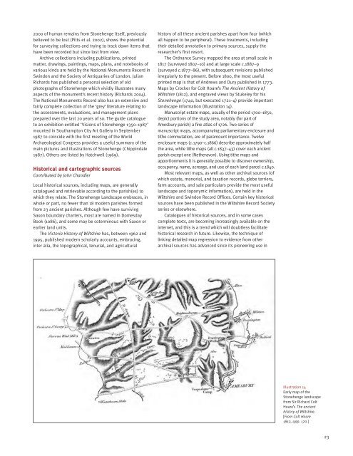
Maps by Crocker for Colt Hoare’s The Ancient History of<br />
Wiltshire (1812), and engraved views by Stukeley for his<br />
Stonehenge (1740, but executed 1721–4) provide important<br />
landscape information (Illustration 14).<br />
Manuscript estate maps, usually of the period 1700–1850,<br />
depict portions of the study area, notably (for part of<br />
Amesbury parish) a fine atlas of 1726. Two series of<br />
manuscript maps, accompanying parliamentary enclosure and<br />
tithe commutation, are of paramount importance. Twelve<br />
enclosure maps (c.1790–c.1866) describe approximately half<br />
the area, while tithe maps (all c.1837–43) cover each ancient<br />
parish except one (Netheravon). Using tithe maps and<br />
apportionments it is generally possible to discover ownership,<br />
occupancy, name, acreage, and use of each land parcel c.1840.<br />
Most relevant maps, as well as other archival sources (of<br />
which estate, manorial, and taxation records, glebe terriers,<br />
farm accounts, and sale particulars provide the most useful<br />
landscape and toponymic information), are held in the<br />
Wiltshire and Swindon Record Offices. Certain key historical<br />
sources have been published in the Wiltshire Record Society<br />
series or elsewhere.<br />
Catalogues of historical sources, and in some cases<br />
complete texts, are becoming increasingly available on the<br />
internet, and this is a trend which will doubtless facilitate<br />
historical research in future. Likewise, the technique of<br />
linking detailed map regression to evidence from other<br />
archival sources has advanced since its pioneering use in<br />
Illustration 14<br />
Early map of the<br />
Stonehenge landscape<br />
from Sir Richard Colt<br />
Hoare’s The ancient<br />
history of Wiltshire.<br />
[From Colt Hoare<br />
1812, opp. 170.]<br />
23


