

stonehenge - English Heritage
stonehenge - English Heritage
stonehenge - English Heritage

You also want an ePaper? Increase the reach of your titles
YUMPU automatically turns print PDFs into web optimized ePapers that Google loves.
047-120 section 2.qxd 6/21/05 4:19 PM Page 68<br />
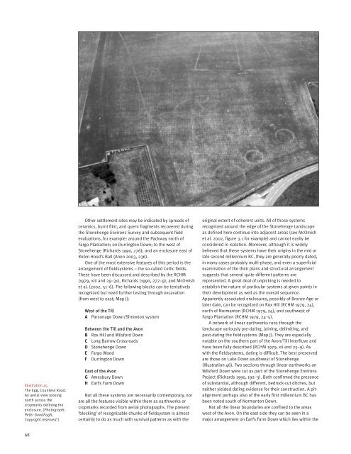
Illustration 45<br />
The Egg, Countess Road.<br />
An aerial view looking<br />
north across the<br />
cropmarks defining the<br />
enclosure. [Photograph:<br />
Peter Goodhugh,<br />
Copyright reserved.]<br />
Other settlement sites may be indicated by spreads of<br />
ceramics, burnt flint, and quern fragments recovered during<br />
the Stonehenge Environs Survey and subsequent field<br />
evaluations, for example: around the Packway north of<br />
Fargo Plantation; on Durrington Down; to the west of<br />
Stonehenge (Richards 1990, 276); and an enclosure east of<br />
Robin Hood’s Ball (Anon 2003, 236).<br />
One of the most extensive features of this period is the<br />
arrangement of fieldsystems – the so-called Celtic fields.<br />
These have been discussed and described by the RCHM<br />
(1979, xiii and 29–31), Richards (1990, 277–9), and McOmish<br />
et al. (2002, 51–6). The following blocks can be tentatively<br />
recognized but need further testing through excavation<br />
(from west to east; Map J):<br />
West of the Till<br />
A Parsonage Down/Shrewton system<br />
Between the Till and the Avon<br />
B Rox Hill and Wilsford Down<br />
C Long Barrow Crossroads<br />
D Stonehenge Down<br />
E Fargo Wood<br />
F Durrington Down<br />
East of the Avon<br />
G Amesbury Down<br />
H Earl’s Farm Down<br />
Not all these systems are necessarily contemporary, nor<br />
are all the features visible within them as earthworks or<br />
cropmarks recorded from aerial photographs. The present<br />
‘blocking’ of recognizable chunks of fieldsystem is almost<br />
certainly to do as much with survival patterns as with the<br />
original extent of coherent units. All of those systems<br />
recognized around the edge of the Stonehenge Landscape<br />
as defined here continue into adjacent areas (see McOmish<br />
et al. 2002, figure 3.1 for example) and cannot easily be<br />
considered in isolation. Moreover, although it is widely<br />
believed that these systems have their origins in the mid or<br />
late second millennium BC, they are generally poorly dated,<br />
in many cases probably multi-phase, and even a superficial<br />
examination of the their plans and structural arrangement<br />
suggests that several quite different patterns are<br />
represented. A great deal of unpicking is needed to<br />
establish the nature of particular systems at given points in<br />
their development as well as the overall sequence.<br />
Apparently associated enclosures, possibly of Bronze Age or<br />
later date, can be recognized on Rox Hill (RCHM 1979, 24),<br />
north of Normanton (RCHM 1979, 24), and southwest of<br />
Fargo Plantation (RCHM 1979, 24–5).<br />
A network of linear earthworks runs through the<br />
landscape variously pre-dating, joining, delimiting, and<br />
post-dating the fieldsystems (Map J). They are especially<br />
notable on the southern part of the Avon/Till interfluve and<br />
have been fully described (RCHM 1979, xii and 25–9). As<br />
with the fieldsystems, dating is difficult. The best preserved<br />
are those on Lake Down southwest of Stonehenge<br />
(Illustration 46). Two sections through linear earthworks on<br />
Wilsford Down were cut as part of the Stonehenge Environs<br />
Project (Richards 1990, 192–3). Both confirmed the presence<br />
of substantial, although different, bedrock-cut ditches, but<br />
neither yielded dating evidence for their construction. A pitalignment<br />
perhaps also of the early first millennium BC has<br />
been noted south of Normanton Down.<br />
Not all the linear boundaries are confined to the areas<br />
west of the Avon. On the east side they can be seen in a<br />
major arrangement on Earl’s Farm Down which lies within the<br />
68


