

stonehenge - English Heritage
stonehenge - English Heritage
stonehenge - English Heritage

Create successful ePaper yourself
Turn your PDF publications into a flip-book with our unique Google optimized e-Paper software.
047-120 section 2.qxd 6/21/05 4:19 PM Page 73<br />
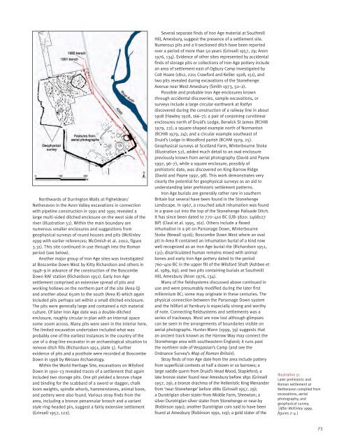
Northwards of Durrington Walls at Figheldean/<br />
Netheravon in the Avon Valley excavations in connection<br />
with pipeline construction in 1991 and 1995 revealed a<br />
large multi-sided ditched enclosure on the west side of the<br />
river (Illustration 51). Within the main boundary are<br />
numerous smaller enclosures and suggestions from<br />
geophysical surveys of round houses and pits (McKinley<br />
1999 with earlier references; McOmish et al. 2002, figure<br />
3.31). This site continued in use through into the Roman<br />
period (see below).<br />
Another major group of Iron Age sites was investigated<br />
at Boscombe Down West by Kitty Richardson and others in<br />
1948–9 in advance of the construction of the Boscombe<br />
Down RAF station (Richardson 1951). Early Iron Age<br />
settlement comprised an extensive spread of pits and<br />
working hollows on the northern part of the site (Area Q)<br />
and another about 650m to the south (Area R) which again<br />
included pits perhaps set within a small ditched enclosure.<br />
The pits were generally large and contained a rich material<br />
culture. Of later Iron Age date was a double-ditched<br />
enclosure, roughly circular in plan with an internal space<br />
some 200m across. Many pits were seen in the interior here.<br />
The limited excavation undertaken included what was<br />
probably one of the earliest instances in the country of the<br />
use of a drag-line excavator in an archaeological situation to<br />
remove ditch fills (Richardson 1951, plate 5). Further<br />
evidence of pits and a posthole were recorded at Boscombe<br />
Down in 1998 by Wessex Archaeology.<br />
Within the World <strong>Heritage</strong> Site, excavations on Wilsford<br />
Down in 1910–13 revealed traces of a settlement that again<br />
included two storage pits. One pit yielded a bronze chape<br />
and binding for the scabbard of a sword or dagger; chalk<br />
loom weights, spindle whorls, hammerstones, animal bone,<br />
and pottery were also found. Various stray finds from the<br />
area, including a bronze penannular brooch and a variant<br />
style ring-headed pin, suggest a fairly extensive settlement<br />
(Grinsell 1957, 122).<br />
Several separate finds of Iron Age material at Southmill<br />
Hill, Amesbury, suggest the presence of a settlement site.<br />
Numerous pits and a V-sectioned ditch have been reported<br />
over a period of more than 50 years (Grinsell 1957, 29; Anon<br />
1976, 134). Evidence of other sites represented by accidental<br />
finds of storage pits or collections of Iron Age pottery include<br />
an area of settlement east of Ogbury Camp investigated by<br />
Colt Hoare (1812, 220; Crawford and Keiller 1928, 151), and<br />
two pits revealed during excavations of the Stonehenge<br />
Avenue near West Amesbury (Smith 1973, 50–2).<br />
Possible and probable Iron Age enclosures known<br />
through accidental discoveries, sample excavations, or<br />
surveys include a large circular earthwork at Ratfyn<br />
discovered during the construction of a railway line in about<br />
1908 (Hawley 1928, 166–7); a pair of conjoining curvilinear<br />
enclosures north of Druid’s Lodge, Berwick St James (RCHM<br />
1979, 22); a square-shaped example north of Normanton<br />
(RCHM 1979, 24); and a circular example southeast of<br />
Druid’s Lodge in Woodford parish (RCHM 1979, 25).<br />
Geophysical surveys at Scotland Farm, Winterbourne Stoke<br />
(Illustration 52), added much detail to an oval enclosure<br />
previously known from aerial photography (David and Payne<br />
1997, 96–7), while a square enclosure, possibly of<br />
prehistoric date, was discovered on King Barrow Ridge<br />
(David and Payne 1997, 98). This work demonstrates very<br />
clearly the potential for geophysical surveys as an aid to<br />
understanding later prehistoric settlement patterns.<br />
Iron Age burials are generally rather rare in southern<br />
Britain but several have been found in the Stonehenge<br />
Landscape. In 1967, a crouched adult inhumation was found<br />
in a grave cut into the top of the Stonehenge Palisade Ditch.<br />
It has since been dated to 770–410 BC (UB-3820: 2468±27<br />
BP) (Cleal et al. 1995, 161). Others include a flexed<br />
inhumation in a pit on Parsonage Down, Winterbourne<br />
Stoke (Newall 1926); Boscombe Down West where an oval<br />
pit in Area R contained an inhumation burial of a kind now<br />
well recognized as an Iron Age burial rite (Richardson 1951,<br />
131); disarticulated human remains mixed with animal<br />
bones and early Iron Age pottery dated to the period<br />
760–400 BC in the upper fill of the Wilsford Shaft (Ashbee et<br />
al. 1989, 69); and two pits containing burials at Southmill<br />
Hill, Amesbury (Anon 1976, 134).<br />
Many of the fieldsystems discussed above continued in<br />
use and were presumably modified during the later first<br />
millennium BC; some may originate in these centuries. The<br />
physical connection between the Parsonage Down system<br />
and the hillfort at Yarnbury is especially strong and worthy<br />
of note. Connecting fieldsystems and settlements was a<br />
series of trackways. Most are now lost although glimpses<br />
can be seen in the arrangements of boundaries visible on<br />
aerial photographs. Hunter-Mann (1999, 39) suggests that<br />
an ancient track known as the Harrow Way may connect the<br />
Stonehenge area with southeastern England; it runs past<br />
the northern side of Vespasian’s Camp (and see the<br />
Ordnance Survey’s Map of Roman Britain).<br />
Stray finds of Iron Age date from the area include pottery<br />
from superficial contexts at half a dozen or so barrows; a<br />
large saddle quern from Druid’s Head Wood, Stapleford; a<br />
late bronze stater found near Amesbury before 1891 (Grinsell<br />
1957, 29); a bronze drachma of the Hellenistic King Menander<br />
from ‘near Stonehenge’ before 1880 (Grinsell 1957, 29);<br />
a Durotrigian silver stater from Middle Farm, Shrewton; a<br />
silver Durotrigian silver stater from Stonehenge or near-by<br />
(Robinson 1991); another Durotrigian coin said to have been<br />
found at Amesbury (Robinson 1991, 119); a gold stater of the<br />
Illustration 51<br />
Later prehistoric and<br />
Roman settlement at<br />
Netheravon compiled from<br />
excavations, aerial<br />
photography, and<br />
geophysical survey.<br />
[After McKinley 1999,<br />
figures 2–4.]<br />
73


