

stonehenge - English Heritage
stonehenge - English Heritage
stonehenge - English Heritage

You also want an ePaper? Increase the reach of your titles
YUMPU automatically turns print PDFs into web optimized ePapers that Google loves.
047-120 section 2.qxd 6/21/05 4:18 PM Page 60<br />
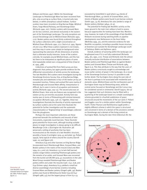
Illustration 38<br />
Late Neolithic house<br />
revealed below Durrington<br />
68. [After Pollard 1995b,<br />
figure 2.]<br />
(Gibson and Kinnes 1997). Within the Stonehenge<br />
Landscape no Peterborough Ware has been recovered from<br />
pits, only occurring as surface finds, in buried soils (see<br />
below), or within amorphous subsoil hollows. Surface<br />
scatters have been recorded on King Barrow Ridge, Wilsford<br />
Down, Fargo Wood/Packway, and Stonehenge Down<br />
(Richards 1990, 267). Similar scatters with Grooved Ware<br />
are far less common, and almost exclusively in the eastern<br />
part of the Stonehenge Landscape. The only exceptions are<br />
around Stonehenge and on Wilsford Down (Richards 1990,<br />
270). Beaker pottery was found thinly scattered throughout<br />
the surface collections with a slight concentration on<br />
Wilsford Down (Richards 1990, 271; Cleal et al. 1995, figures<br />
78 and 225). What these scatters represent is not known,<br />
and they may in some cases simply be background noise<br />
representing the extensive off-site dimensions of activity<br />
that is otherwise locally intensive. Some of the scatters<br />
coincide, for example around Wilsford Down, and this has<br />
led them to be interpreted as significant places of some<br />
kind repeatedly visited over a long period of time (Cleal et<br />
al. 1995, 488).<br />
Collections of worked flint from field survey are less<br />
diagnostic than pottery, but again provide evidence for the<br />
differential concentration of activity across the landscape.<br />
Two late Neolithic flint scatters were investigated during the<br />
Stonehenge Environs Survey. One, at King Barrow Ridge,<br />
revealed pits and stakeholes in four of the twelve 5m by 5m<br />
excavated trenches. Pottery and worked flint were mainly of<br />
Peterborough and Grooved Ware affinity. Interpretation is<br />
difficult, but is seen in terms of occupation and domestic<br />
activity (Richards 1990, 109–23). The second area was on<br />
Wilsford Down. Here only one feature was recognized in the<br />
sixteen 5m by 5m trenches excavated. Activity here was<br />
mainly seen in terms of flintworking with minimal domestic<br />
occupation (Richards 1990, 158–71). Together, these two<br />
investigations illustrate the diversity of activity represented<br />
by surface scatters and at the same time illustrate the<br />
potential for further investigation and the systematic<br />
characterization or ‘fingerprinting’ of assemblages collected<br />
from the ploughzone.<br />
Perhaps the most important collections are those<br />
preserved beneath the earthworks and mounds of later<br />
monuments, especially round barrows. These illustrate<br />
great potential for future work, although locating suitable<br />
places to target investigation is always going to be difficult.<br />
Woodhenge Circle 2 (Durrington 68: Illustration 38)<br />
preserved a setting of postholes that has been<br />
reconstructed as the remains of a late Neolithic structure,<br />
possibly a house (Cunnington 1929, 45 and plate 39; Pollard<br />
1995b), fairly typical of others around the country (Darvill<br />
1996, 107 and figure 6.8).<br />
Amesbury G39 and other barrows on King Barrow Ridge<br />
incorporated much Peterborough Ware, Grooved Ware, and<br />
Beaker pottery in the matrix of the mound (Cleal and Allen<br />
1994, 62–5 and 70); Amesbury 133 (a twin bell barrow)<br />
sealed a large hollow containing Peterborough pottery and<br />
the remains of an antler, and Grooved Ware was recovered<br />
from the buried soil (RCHM 1979, 4); excavations in the Lake<br />
Wood Group revealed Peterborough Ware and Beaker<br />
pottery within and under the mounds G36f , G37, G38, and<br />
G39 (Grimes 1964); Amesbury G133 yielded a small but<br />
diverse assemblage of pre-barrow ceramics including<br />
Grooved Ware and Beaker pottery (Gingell 1988, 39); Beaker<br />
pottery was found at Winterbourne Stoke G39 and G47<br />
(Gingell 1988, 54); but the largest group is from G51–54<br />
excavated by Greenfield in 1958 where 144 sherds of<br />
Peterborough Ware, 49 sherds of Grooved Ware, and 5<br />
sherds of Beaker pottery were found in pre-barrow contexts<br />
(Smith 1991, 34–8); Amesbury G61 also yielded a range of<br />
Beaker pottery (Ashbee 1984a, 76–9).<br />
The potential for finding late Neolithic activity on the<br />
lower ground in the main river valleys is hard to assess<br />
because opportunites for looking have been few. Mention<br />
may, however, be made of the assemblage of late Neolithic<br />
flintwork recovered during watching briefs on pipeline<br />
developments near Netheravon on the Avon Valley<br />
(McKinley 1999, 30), and the extensive evidence for late<br />
Neolithic occupation, including a possible house structure,<br />
at Downton just outside the Stonehenge Landscape south<br />
of Salisbury (Rahtz and ApSimon 1962).<br />
Overall, evidence of sectoring within the landscape can<br />
be glimpsed even if it is not fully understood (Richards<br />
1984, 181; 1990, 270). Thorpe and Richards note the almost<br />
mutually exclusive distribution of associations between<br />
Beaker pottery and Peterborough Ware as against Beaker<br />
pottery and Grooved Ware (Thorpe and Richards 1984,<br />
figure 6.3). This they attribute to the way that the users of<br />
Beaker pottery consciously sought to acknowledge and<br />
reuse earlier centres of power in the landscape. As a result<br />
of the Stonehenge Environs Survey it is possible to add<br />
further detail. The Durrington Zone along the east side of<br />
the Avon is perhaps to be associated with residential and<br />
domestic areas, Wilsford Down and the northeastern part of<br />
Durrington Down may be flintworking areas, while the<br />
central sector focused on Stonehenge and the Cursus may<br />
be considered sacred or ceremonial. Darvill (1997a, 182–9)<br />
has suggested that such divisions may be fitted with a<br />
quartering of the landscape based on a simple cosmological<br />
scheme grounded in a fourfold subdivision of space<br />
structured around the movements of the sun (and cf. Pollard<br />
and Ruggles 2001 for a similar pattern within Stonehenge<br />
itself). Parker Pearson and Ramilisonina (1998) prefer a<br />
slightly different scheme in which the space is structured<br />
and conceived in terms of a domain of the ancestors centred<br />
on Stonehenge and a domain of the living centred on<br />
Durrington Walls. During the later third millennium BC the<br />
60


