

stonehenge - English Heritage
stonehenge - English Heritage
stonehenge - English Heritage

You also want an ePaper? Increase the reach of your titles
YUMPU automatically turns print PDFs into web optimized ePapers that Google loves.
047-120 section 2.qxd 6/21/05 4:19 PM Page 67<br />
A third middle or later Bronze Age settlement is<br />
represented at an enclosure known as the Egg, situated a<br />
little to the south of Woodhenge on the western slopes of<br />
the Avon Valley (Illustration 45). Discovered through aerial<br />
photography at the same time as Woodhenge, this<br />
enclosure was sampled through excavation by the<br />
Cunningtons (Cunnington 1929, 49–51; Wainwright and<br />
Longworth 1971, 6; RCHM 1979, 23). The enclosure<br />
boundary comprised a palisade trench, one terminal of<br />
which is extended in a straight line southwards where it<br />
meets a linear ditch. In the interior were 25 pits, one<br />
containing carbonized barley. Subsequent analysis of aerial<br />
photographs and finds recovered from monitoring a pipe<br />
trench suggest that the Egg is part of a more extensive<br />
spread of middle Bronze Age occupation that would repay<br />
detailed investigation (RCHM 1979, 24). A ditch excavated<br />
beside the Packway Enclosure north of Durrington Walls<br />
may also be part of the same system of boundaries<br />
(Wainwright and Longworth 1971, 324).<br />
The fourth site is at Rollestone Grain Store, Shrewton.<br />
Here, field evaluations and excavations in advance of an<br />
expansion to the Wiltshire Grain Facility in 1996 revealed an<br />
enclosure some 60m by 50m in extent, bounded by a ditch<br />
2m wide and over 1m deep. A single entrance lay in the<br />
middle of the western side. Inside the enclosure was a dewpond<br />
(Anon 1998, 163–4).<br />
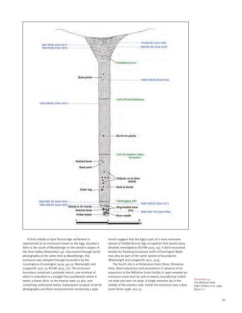
Illustration 44<br />
The Wilsford Shaft.<br />
[After Ashbee et al. 1989,<br />
figure 7.]<br />
67


