

GCOS Implementation Plan - WMO
GCOS Implementation Plan - WMO
GCOS Implementation Plan - WMO

You also want an ePaper? Increase the reach of your titles
YUMPU automatically turns print PDFs into web optimized ePapers that Google loves.
<strong>Implementation</strong> <strong>Plan</strong> for the Global Observing System for Climate in Support of the UNFCCC<br />
(2010 Update)<br />
To consider possible impacts, the effect of isostatic rebound and human action on subsidence needs<br />
to be quantified which locally can be of the same order as global sea-level change. Spatial scales of<br />
drainage-induced subsidence are small requiring a substantial enhancement of the local tide gauge<br />
network or geodetic measurements in critical regions. Jointly with the tide gauge network, continued<br />
operation of high-precision satellite altimetry and sun-synchronous altimeter measurements complete<br />
the sea-level network. Together they represent an integrated strategy for monitoring of sea-level<br />
variability and change globally and on regional scales. The Arctic Ocean is an essential component of<br />
this and needs to be observed as well.<br />
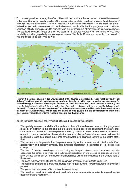
Figure 10: Sea-level gauges in the <strong>GCOS</strong> subset of the GLOSS Core Network. "Near real-time" and "Fast<br />
Delivery" stations provide high-frequency sea level (hourly or better reports) which are necessary for<br />
understanding of sea-level variability in addition to mean sea-level rise. Near real-time stations (blue)<br />
provide data typically within 1 hour of collection; Fast delivery (green) within one month. Delayed-mode<br />
data within 5 years (orange) or greater (red) include monthly averages provided to the Permanent Service<br />
for Mean Sea Level (PSMSL). White dots are placed on tide gauges that are geo-referenced, measuring<br />
local land movements, in order to measure absolute sea-level change.<br />
Issues related to sea-level observing and integrated global analysis include:<br />
• The spatially complex variability of the vertical motion of the surfaces upon which tide gauges are<br />
located. In addition to the ongoing larger-scale tectonic post-glacial adjustment, there are often<br />
local vertical movements of consequence caused by human activities. These vertical movements<br />
are of the same magnitude as the anticipated sea-level change from global warming, and must be<br />
measured at each tide gauge in order to reveal water level changes relative to the centre of the<br />
Earth.<br />
• The existence of large-scale low frequency variability of the oceanic density field which, if not<br />
appropriately and globally sampled, can introduce uncertainty in estimates of global sea-level<br />
change.<br />
• The lack of detailed knowledge of mass being exchanged between polar ice sheets and the<br />
ocean has the potential to introduce a substantial uncertainty in understanding predictions of sealevel<br />
change which can by far exceed the uncertainties arising from changes in the density field of<br />
the ocean.<br />
• The need to know variability and change in surface pressure, which affects water level.<br />
• The technical challenges of making accurate high-frequency water level measurements over long<br />
periods.<br />
• The present shortcomings of international data exchange.<br />
• The need for significant regional and local network enhancements in order to support impact<br />
assessment and monitoring.<br />
82


