

Chapter A - Introduction - City of Pickering
Chapter A - Introduction - City of Pickering
Chapter A - Introduction - City of Pickering

You also want an ePaper? Increase the reach of your titles
YUMPU automatically turns print PDFs into web optimized ePapers that Google loves.
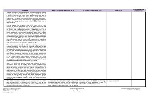
COMMENT MESPA RESPONSE (December 2011) CITY RESPONSE (October 2012) RESPONSE<br />
This was verified by running both models, which resulted in the following<br />
time to peak for flows for Whitevale, Ganatsekiagon and Urfe Creeks <strong>of</strong> 5,<br />
6 and 6.5 hours, from the AMEC Model, whereas the time to peak for<br />
those creeks in Aquafor’s 2002 Model were 9, 9.25 and 8 hours,<br />
respectively. It is important that Aquafor’s 2002 Model was calibrated to 6<br />
different streamflow gauges throughout the Duffins Creek watershed,<br />
including one gauge on Urfe Creek, while AMEC’s Model was not<br />
calibrated at all.<br />
REPORT CHAPTER<br />
AND SECTION<br />
From a Regional flow perspective, the MESP states that the model<br />
indicates an increase in Regional flows <strong>of</strong> 3% at the downstream node<br />
through the <strong>Pickering</strong>/Ajax Special Policy Area (SPA) and the location <strong>of</strong><br />
the Duffins Dyke. The MESP recommends that Regional control not be<br />
provided in the stormwater facilities as widespread distributed regional<br />
control is expected to increase downstream flow levels more. However,<br />
the actual analysis was not completed. Alternatively, the MESP<br />
recommends the formalization <strong>of</strong> natural valley storage that exists within<br />
Ganatsekiagon Creek and Urfe Creek. It is unlikely this recommendation<br />
will be approved by TRCA, therefore, regional control may be required<br />
within the neighbourhood plans. This means that efficiencies may need to<br />
be found such as co-location <strong>of</strong> stormwater facilities and parks, otherwise<br />
large tracts <strong>of</strong> land may be required for regional storage.<br />
The recommendation that 2 to 100 year and Regional stormwater<br />
quantity controls are not required for Whitevale Creek has not been<br />
appropriate justified. It is understood that the reason that no water<br />
quantity controls are proposed within Whitevale Creek was to ensure that<br />
the flows from this subcatchment are conveyed through the system prior<br />
to the peak flows from the upstream West Duffins catchments arriving<br />
which thereby lessens the downstream flooding impacts. However, this<br />
does not take into account the impact that uncontrolled flows would have<br />
on the instream channel itself – namely, from the lower return period<br />
flows, which could significantly change the existing channel form,<br />
especially if the re-calibration shows that the existing flows for Whitevale<br />
Creek are reduced and closer to the Aquafor 2002 Model.<br />
Given the deficiencies outlined above, the reliability <strong>of</strong> AMEC’s<br />
uncalibrated model and the validity <strong>of</strong> the report’s recommendations<br />
cannot be accepted at this time. Staff recommends that the Aquafor 2002<br />
Model be updated to include the more specific information from the<br />
Seaton area utilizing the same methodology for determining the<br />
parameters (CN*, time to peak, area, subcatchments etc.) and calibration<br />
procedure in order to recalibrate the model using eight more years <strong>of</strong><br />
streamflow and rainfall data (from 2002 to 2010). Accurate modelling is<br />
required in order to move forward and make reasonably accurate<br />
recommendations for such a large-scale development as Seaton,<br />
specifically due to the known presence <strong>of</strong> the flood prone communities<br />
downstream.<br />
The Future Conditions model will be updated using the <strong>City</strong>’s<br />
Neighbourhood Plans. The following run<strong>of</strong>f coefficients should be used<br />
for the different land uses as they reflect the actual built form that is to be<br />
expected in Seaton as stated in Section 8.1.<br />
As discussed at the technical meeting, the <strong>City</strong>’s run<strong>of</strong>f<br />
coefficients have been utilized. The RC values have<br />
been converted to percent impervious. Where this<br />
results in percent impervious greater than or equal to<br />
No action required for MESPA as hydrology<br />
component is being addressed through the<br />
2012 Duffins Creek Hydrology Update.<br />
No response required.<br />
The Sernas Group Inc., Stonybrook Consulting Inc. December 2011, Revised February 2013 Master Environmental Servicing Plan - Amendment<br />
SPL Beatty, Bird and Hale Limited, Earthfx Inc. 07161 Seaton Community, <strong>City</strong> <strong>of</strong> <strong>Pickering</strong><br />
AMEC Earth & Environmental, R.J. Burnside Appendix A7 – Page 9<br />
Amos Environment + Planning


