

Chapter A - Introduction - City of Pickering
Chapter A - Introduction - City of Pickering
Chapter A - Introduction - City of Pickering

Create successful ePaper yourself
Turn your PDF publications into a flip-book with our unique Google optimized e-Paper software.
RESPONSE TO CITY COMMENTS<br />
SWMF LOCATIONS<br />
(APPENDIX B)<br />
30<br />
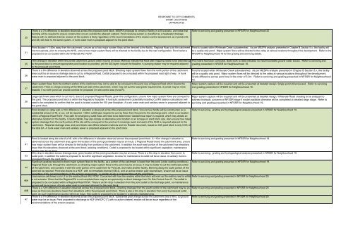
There is a 7m difference in elevation observed across the proposed pond block. MESPA proposes to construct facility in a fill scenario, and notes that<br />
berming will be required to ensure construction occurs outside the adjacent wetland. Pond receiving system is classified as a headwater drainage<br />
feature with no defined channel, erosion <strong>of</strong> this system is likely regardless <strong>of</strong> the recommendations <strong>of</strong> the erosion control assessment, as 2 ponds (30,<br />
and 48) will drain to the same system. A trunk water main is proposed adjacent to the pond block.<br />
Refer to servicing and grading presented in NFSSR for Neighbourhood 20<br />
31<br />
35<br />
36<br />
37<br />
38<br />
40<br />
Pond located +/-140m away from the catchment, unsure as to how major system flows will be directed to the facility. Regional Road cuts the catchment<br />
into two parcels, prior to crossing the NHS, unsure how major system flows will be directed to the facility due to the road configuration. Pond outlet is<br />
proposed to be co located within the Whitevale Rd. ROW.<br />
15m change in elevation within the ponds catchment, ground water may be an issue. Matrices indicate that flood plain mapping needs to be extended up<br />
to the pond block to ensure appropriate pond location is provided, yet the GIS layers include the floodline. A pumping station may be required adjacent<br />
to the proposed pond block.<br />
There is a 6m difference in elevation observed across the proposed pond block. Directing major system flows from the north portion <strong>of</strong> the catchment<br />
area could be an issue as drainage area is cut by a Regional Road. Outfall proposed to be co-located within the proposed road right <strong>of</strong> way. A trunk<br />
water main is proposed adjacent to the pond block.<br />
Major system flows from the northern portion <strong>of</strong> the catchment may not be able to be conveyed to the pond due a Regional Road which bisects the<br />
catchment. There is a large crossing <strong>of</strong> the NHS just east <strong>of</strong> the catchment, which may set out the road grade requirements. 2 ponds may be more<br />
feasible, if so north pond can provide controls for proposed On site control area (Area R).<br />
Large catchment area which is cut into 3, due to 2 proposed Regional Roads, given this configuration, unsure how major system flows are conveyed to<br />
the pond. The proposed pond block is within the Regulatory floodplain. A hydraulic assessment (potentially including Cut/Fill balance calculations) will<br />
need to be completed to confirm that the pond is located outside the 100 year floodplain. A trunk water main and sanitary sewer is proposed adjacent to<br />
the pond block.<br />
Pond is located within Whitevale Creek subwatershed. As per MESPA analysis presented in <strong>Chapter</strong> B Section 5.x, this facility will<br />
be a quality only pond. Major system flows will be directed to the valley at various locations throughout the development. Refer to the<br />
NFSSR for Neighbourhood 18 for the grading and servicing details.<br />
The matrix has been corrected. Soils work to date indicates no insurmountable ground water issues. Refer to servicing and<br />
grading presented in NFSSR for Neighbourhood 18.<br />
Pond is located within Whitevale Creek subwatershed. As per MESPA analysis presented in <strong>Chapter</strong> B Section 5.x, this facility<br />
will be a quality only pond. Major system flows will be directed to the valley at various locations throughout the development.<br />
Grade difference across pond now in the order <strong>of</strong> 5.0m. Refer to servicing and grading presented in NFSSR for Neighbourhood<br />
18.<br />
Major system capture will be required and will be presented at detailed design. Single pond still proposed. Refer to servicing<br />
and grading presented in NFSSR for Neighbourhood 18.<br />
Major system capture will be required and will be presented at detailed design. Whitevale Road crossing to be analyzed to<br />
address hydraulic concerns at NFSSR stage if model available otherwise will be completed at detailed deign stage. Refer to<br />
servicing and grading presented in NFSSR for Neighbourhood 19.<br />
Pond located on valley wall, a 10m difference in elevation is observed across the proposed pond block. Unsure how facility will be constructed, as a Refer to servicing, grading and hydrogeological analysis presented in NFSSR for Neighbourhood 19.<br />
substantial amount <strong>of</strong> fill, or cut, will be required. +350m outfall pipe required to convey flows from the pond to the discharge point, which is co-located<br />
within a Regional Road ROW. Flow path for emergency outlet flows will need to be determined. Geotechnical report is required, which may dictate an<br />
alternative location for the facility. Constructability may also dictate an alternative pond location or an increase in pond block size. Also unsure how major<br />
system drainage from the north portion <strong>of</strong> the site will be conveyed to the pond as 2 crossings (west and east) <strong>of</strong> the NHS is required adjacent to the<br />
catchment. Reported drainage area, and pond block size differs between matrices and Arc Reader document, based on GIS pond block is only 5.5% <strong>of</strong><br />
the total DA. A trunk water main and sanitary sewer is proposed adjacent to the pond block.<br />
41<br />
43<br />
44<br />
46A<br />
46B<br />
47<br />
Pond is located along the side <strong>of</strong> a hill, with a 5m difference in elevation observed across the proposed pond block. A +10m change in elevation is Refer to servicing and grading presented in NFSSR for Neighbourhood 19.<br />
observed across the catchment area; given the location <strong>of</strong> the pond groundwater may be an issue. 2 Regional Roads bisect the catchment area, unsure<br />
how major system flows will be directed to the facility from portions <strong>of</strong> the catchment. In addition the south east portion <strong>of</strong> the catchment has elevations<br />
lower than the elevations observed at the pond block (existing conditions). Outlet is proposed to be located within significant vegetation; maintenance<br />
access may be an issue.<br />
30m drop in elevation across drainage area, given location <strong>of</strong> the pond groundwater may be an issue. There is a 9m drop in elevation from pond, to Refer to servicing, grading and hydrogeological analysis presented in NFSSR for Neighbourhood 19.<br />
outlet point; in addition the outlet is proposed to be within significant vegetation. Access for maintenance to outlet will be an issue. A sanitary trunk is<br />
proposed through the pond block.<br />
Significant grading required to direct major system flows to the facility, as a portion <strong>of</strong> the catchment is lower than the pond (under existing conditions). Refer to servicing and grading presented in NFSSR for Neighbourhood 19.<br />
Regional Road cuts through the catchment, so directing major system flows to the pond may be an issue. It may be better to cut the northwest portion<br />
<strong>of</strong> the catchment, and combine it with the north portion <strong>of</strong> the catchment for Pond 26, and make another facility. Berming along the south portion <strong>of</strong> the<br />
pond will be required. Pond also drains to a HDF, with no immediate channel (GB-4), and an active erosion gully downstream, erosion will be an issue<br />
regardless <strong>of</strong> the recommendations <strong>of</strong> the erosion assessment. A sanitary trunk is proposed through the pond block.<br />
Long narrow catchment cut in 2 by the existing Brock Rd. ROW. Concerned with how the grading within the block will work as the existing road is within Refer to servicng and grading presented in NFSSR for Neighbourhood 20.<br />
a cut scenario. Given that the Regional EA is not complete there may be an opportunity to direct drainage from On Site Control Area G. The outfall is<br />
proposed to be co-located within a Regional Road ROW. There is an 8m drop in elevation from the pond outlet to the discharge point, so maintenance<br />
access will be an issue. A trunk water main is proposed adjacent to the pond block.<br />
There is a 12m difference in elevation observed across the proposed pond block. Directing drainage from the south portion <strong>of</strong> the catchment may be an Refer to servicng and grading presented in NFSSR for Neighbourhood 20.<br />
issue as there are elevations lower than elevations within the proposed pond block. There is also a 9m drop in elevation from pond to proposed outlet<br />
point; as such maintenance access will be an issue. Also outlet is proposed to be located in a densely vegetated area.<br />
There is a 7m difference in elevation observed across the proposed pond block. Substantial grad change across the catchment area (18m), so ground Refer to servicng and grading presented in NFSSR for Neighbourhood 20.<br />
water may be an issue. Pond proposed to discharge to HDF (HWDFC17) with no active channel, erosion will be an issue regardless <strong>of</strong> the<br />
recommendations <strong>of</strong> the erosion analysis.


