Chapter A - Introduction - City of Pickering
Chapter A - Introduction - City of Pickering
Chapter A - Introduction - City of Pickering
Create successful ePaper yourself
Turn your PDF publications into a flip-book with our unique Google optimized e-Paper software.
Comments in white are satisfied.<br />
Comments in orange background are not satisfied or are new comments.<br />
Comments in blue background can be addressed at the NFSSR stage.<br />
Comments in yellow are deferred due to need for hydrology model.<br />
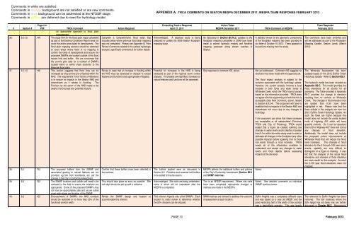
APPENDIX A. TRCA COMMENTS ON SEATON MESPA DECEMBER 2011; MESPA TEAM RESPONSE FEBRUARY 2013<br />
# Section #<br />
Page # in<br />
PDF TRCA Comment Action Required<br />
an appropriate approach to flood plain<br />
management.<br />
36. 5.5.1.2 146 The study limit for the flood plain maps completed<br />
as part <strong>of</strong> the Existing Conditions Report does not<br />
cover the entire area slated for development. The<br />
flood plain mapping exercise should be extended<br />
to cover areas where there is no mapping to<br />
confirm the limits <strong>of</strong> development and ensure the<br />
proposed SWMFs are located outside <strong>of</strong> the flood<br />
hazard limit and buffer. We are concerned that<br />
the current plan calls for a number <strong>of</strong> SWMFs<br />
located within or within close proximity to the<br />
Regional flood plain.<br />
37. 5.5.1.2 146 This section suggests that flood lines can be<br />
increased as long as they are contained within the<br />
NHS. The requirement in the Terms <strong>of</strong> Reference<br />
is to ensure no impacts to the Seaton NHS and<br />
downstream as it relates to flooding. The<br />
Province as the owner <strong>of</strong> the NHS needs to be<br />
aware <strong>of</strong> and accept any potential impacts.<br />
38. 6.2 152 The proposed buffers from the SWMF and<br />
associated grading to natural features are not<br />
provided, eg.10m from woodlands, etc. per the<br />
policies in the <strong>City</strong>’s Conformity Amendment.<br />
39. 6.2 152 The SWMF locations and outfalls will need to be<br />
reviewed in the field to ensure the locations are<br />
appropriate. Some <strong>of</strong> the proposed SWMFs may<br />
not have an appropriately safe and secure outfall<br />
given side slopes and location <strong>of</strong> the SWMF.<br />
40. 6.2 152 Encroachment <strong>of</strong> SWMFs into NHS corridors<br />
should be restricted to no more than 25% <strong>of</strong> the<br />
functional corridor width.<br />
Complete a comprehensive flood study that<br />
includes areas where previous flood plain mapping<br />
was not completed. Please see Appendix B, Peer<br />
Review Comments related to the surface hydrologic<br />
analysis, specifically comments 6 for further details.<br />
Revise to state that an increase in flooding within<br />
the NHS must be assessed for impacts to natural<br />
features and functions and appropriately mitigated.<br />
Confirm that these buffers have been reflected in<br />
the matrices.<br />
This should take place as soon as possible. Site<br />
visit days should be set up well in advance.<br />
Revise the SWMF design and location to<br />
accommodate this criterion.<br />
Consulting Team’s Response<br />
April 27, 2011<br />
Acknowledged. A separate study is being<br />
prepared to update the 2006 Seaton floodplain<br />
mapping study.<br />
Potential for increases in the NHS is being<br />
assessed as part <strong>of</strong> the regional storm control<br />
analysis. If increases are identified, increases to<br />
natural features and functions will be assessed.<br />
The buffers applied were as discussed in<br />
Section 6.2. Floodline and meander belt buffers<br />
to be added to the discussion.<br />
Acknowledged. Site visits are being undertaken,<br />
some <strong>of</strong> which will be undertaken after the<br />
MESPA is completed.<br />
This criterion impacts only a few SWMFs. Each<br />
location is under review to determine whether<br />
the 50% intrusion can be reduced.<br />
Action Taken<br />
MESPA December 2011<br />
As discussed in Section B5.10.2, updates to the<br />
floodplain mapping completed in 2006 have been<br />
made to extend hydraulic models and floodline<br />
mapping upstream along stream reaches in<br />
Seaton.<br />
See response to comment #33, above.<br />
MESPA reflects the additional buffers and policies<br />
<strong>of</strong> the <strong>City</strong>’s Conformity Amendment (Section B6.2<br />
and SWMF matrices).<br />
This is an NFSSR requirement. Where site visits<br />
have been completed, appropriate changes to<br />
matrices are made in the MESPA.<br />
SWM matrices are revised to address the outcome<br />
<strong>of</strong> assessment at each location.<br />
TRCA Comment on MESPA<br />
A detailed review <strong>of</strong> the geometric components<br />
<strong>of</strong> the floodplain mapping has been provided in<br />
our letter <strong>of</strong> October 19, 2012. There appears to<br />
be sections missing from the study.<br />
Not yet addressed. Comment #33 suggests no<br />
resolution has been made with the agencies yet.<br />
The flood impact analysis is subject to the<br />
revisions associated with the hydrology update.<br />
However, the current analysis involves a local<br />
increase in both flows and water levels in<br />
Whitevale Creek, which the TRCA cannot accept<br />
based on the information provided. TRCA does<br />
not agree with the arguments put forth that this is<br />
acceptable (See New Comment, above, related<br />
to Section 5.9.3.4). The proponent will have to<br />
establish that no impacts to the Seaton NHS and<br />
downstream will occur due to any changes in<br />
hydrology.<br />
If the proponent can show that these increases<br />
are acceptable to all stakeholders (Province,<br />
TRCA and <strong>City</strong> <strong>of</strong> <strong>Pickering</strong>), TRCA would<br />
expect that a figure be created outlining any<br />
changes in water levels and/or depths <strong>of</strong> greater<br />
than 0.1m within the entire study area in order to<br />
delineate all changes in the floodplain (any other<br />
possible impacts) before agreeing that no flood<br />
risk exists through a local increase. TRCA<br />
needs all <strong>of</strong> the information available to<br />
understand and accept any changes to water<br />
levels and flood depths before assessing<br />
impacts at the site level.<br />
Noted.<br />
Noted. See detailed comments on individual<br />
SWMF locations below.<br />
Duffin Heights was a completely different case<br />
and was based on a very old MESP, and the<br />
pond restricting half <strong>of</strong> the width <strong>of</strong> the corridor<br />
was a best-efforts scenario. This was largely<br />
Team Response<br />
February 2013<br />
The comments have been reviewed and<br />
will be addressed as part <strong>of</strong> the Floodplain<br />
Mapping Update, Seaton Lands (March<br />
2013).<br />
The Whitevale Assessment has been<br />
updated based on the 2012 Duffins Creek<br />
Hydrology Update. Refer to Section B5.3.<br />
The hydraulic model has been included as<br />
Appendix B5-C. This model provides the<br />
flood elevations for all storms for all<br />
scenarios. The Table provided in Appendix<br />
B5-C provides the change in elevation<br />
resulting from no controls on Whitevale<br />
Creek. The changes in flood elevation that<br />
are greater than 0.3m have been<br />
highlighted in red. Please note that the<br />
flows utilized in this analysis are from the<br />
2012 Duffins Creek Hydrology Update. As<br />
such the flows are higher because the<br />
model does not include the ponds located<br />
north <strong>of</strong> Highway 407 which will have<br />
quantity controls. So it can be assumed<br />
that north <strong>of</strong> Highway 407 there will not be<br />
any changes in flood elevation.<br />
Additionally, the model does not include<br />
the proposed culvert improvements at<br />
Whitevale Road that will reduce the flood<br />
level increases. The changes in flood<br />
elevation for the 2 through 100 year storm<br />
events, spatially are very difficult to<br />
distinguish on a figure or drawing. It was<br />
felt that the analysis <strong>of</strong> the actual flood<br />
elevations and changes in flood elevation<br />
are more useful for this analysis. As such<br />
the 2-100 year flood elevations were not<br />
mapped.<br />
The reference to Duffin Heights has been<br />
removed. The few instances where the<br />
25% target has not been met are further<br />
discussed in <strong>Chapter</strong> B6.3. Recognizing<br />
PAGE 10 February 2013


