

Chapter A - Introduction - City of Pickering
Chapter A - Introduction - City of Pickering
Chapter A - Introduction - City of Pickering

You also want an ePaper? Increase the reach of your titles
YUMPU automatically turns print PDFs into web optimized ePapers that Google loves.
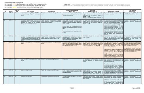
Comments in white are satisfied.<br />
Comments in orange background are not satisfied or are new comments.<br />
Comments in blue background can be addressed at the NFSSR stage.<br />
Comments in yellow are deferred due to need for hydrology model.<br />
APPENDIX A. TRCA COMMENTS ON SEATON MESPA DECEMBER 2011; MESPA TEAM RESPONSE FEBRUARY 2013<br />
# Section #<br />
Page # in<br />
PDF TRCA Comment Action Required<br />
94. SWMF #10 846 Erosion implications <strong>of</strong> outletting a SWMF to a Province to provide direction with regard to species<br />
headwater tributary. This is a redside dace at risk.<br />
tributary.<br />
95. SWMF #11 847 Why does the fisheries setback extend onto the<br />
development lands? What are the erosion<br />
implications <strong>of</strong> outletting to the intermittent<br />
tributary. This is a redside dace tributary.<br />
96. SWMF #12 848 Encroaches on CUT1-E, which is a thicket<br />
community. Proposing to outlet to small tributary.<br />
Is it better to outlet to larger system and take ro<strong>of</strong><br />
water to top <strong>of</strong> tributary? This is a redside dace<br />
tributary.<br />
97. SWMF #13 849 Butternut in vicinity and this is a redside dace<br />
tributary.<br />
98. SWMF #14 850 Issues with SWMF outlet and wetland water<br />
balance.<br />
Provide rationale for fisheries setback and provide<br />
erosion assessment. Province to provide direction<br />
with regard to species at risk.<br />
Relocate SMWF to avoid thicket communities.<br />
Provide analysis for watercourse. Province to<br />
provide direction with regard to species at risk<br />
Province to provide direction with regard to species<br />
at risk.<br />
Consulting Team’s Response<br />
April 27, 2011<br />
An overall benefit plan for redside dace is being<br />
prepared, and a workshop will be held with<br />
TRCA and MNR to discuss.<br />
As the MESP team was not involved in the<br />
establishment <strong>of</strong> the NHS, we can provide no<br />
insight as to why the 30 m fisheries setback falls<br />
outside the NHS.<br />
An overall benefit plan for redside dace is being<br />
prepared, and a workshop held with TRCA and<br />
MNR.<br />
The erosion assessment will be completed in the<br />
NFSSR.<br />
The natural heritage conditions in the location <strong>of</strong><br />
the proposed pond block are being evaluated<br />
further in the MESPA and a headwater feature<br />
water balance is being undertaken.<br />
All areas are being investigated for butternuts in<br />
the NFSSRs. An overall benefit plan for redside<br />
dace is being prepared, and a workshop will be<br />
held with TRCA and MNR to discuss.<br />
Action Taken<br />
MESPA December 2011<br />
The basis for an overall benefit plan and/or<br />
mitigation plan for redside dace and a fisheries<br />
compensation plan are included in the MESPA,<br />
<strong>Chapter</strong>s E and F.<br />
Mitigation is required for all outlets – as required by<br />
the legislation.<br />
The basis for an overall benefit plan and/or<br />
mitigation plan for redside dace and a fisheries<br />
compensation plan are included in the MESPA,<br />
<strong>Chapter</strong>s E and F.<br />
SWMF#12 is relocated and the matrix for this<br />
SWMF is revised.<br />
The basis for an overall benefit plan and/or<br />
mitigation plan for redside dace and a fisheries<br />
compensation plan are included in the MESPA.<br />
Butternut is also addressed. See <strong>Chapter</strong> E.<br />
See earlier comments regarding G4a, b, and c. Under review. The water balance for Wetlands G4a, G4b, G4c<br />
have been reassessed, and required mitigations<br />
provided.<br />
TRCA Comment on MESPA<br />
Please confirm that the appropriate length to<br />
width ratio can be achieved<br />
The direction <strong>of</strong> flow in the pond is opposite to<br />
the prevailing grade; please confirm that grading<br />
within the block provided is possible. The<br />
groundwater table is a potential constraint and<br />
must be further investigated at the NFSSR stage<br />
to confirm pond location/site grading. The pond<br />
is not at the bottom end <strong>of</strong> the site - is it in the<br />
optimal location and can site grading be<br />
completed to make this pond location work?<br />
Please confirm that all drainage can be safely<br />
conveyed across/under Taunton Road to the<br />
pond, in meeting with municipal/regional<br />
standards.<br />
Please confirm that an appropriate length to<br />
width ratio can be achieved. The pond is<br />
expected to be constructed within the GW table<br />
and requires further investigation.<br />
TRCA agrees with the note that a grading<br />
assessment needs to address the 9m elevation<br />
difference within the pond. This is a major issue<br />
impacting this pond location, and it should be<br />
addressed at the MESPA stage.<br />
Please confirm that the entire drainage area can<br />
be directed to the north end <strong>of</strong> the pond given<br />
the existing topography. Please confirm that all<br />
drainage can be safely conveyed across/under<br />
proposed roadways to the pond (meeting<br />
municipal/regional standards). The pond is<br />
expected to be constructed within the GW table<br />
and requires further investigation.<br />
Noted. Construction impacts associated with the<br />
outfall will need to be minimized by utilizing the<br />
unopened road allowance.<br />
Team Response<br />
February 2013<br />
Comment acknowledged. To be addressed<br />
in NFSSR for Neighbourhood 16.<br />
Comments acknowledged. To be<br />
addressed in NFSSR for Neighbourhood<br />
16.<br />
Comments acknowledged. It is noted that<br />
the elimination <strong>of</strong> this facility is being<br />
investigated in the NFSSR for<br />
Neighbourhood 16.<br />
The NFSSR has advanced the grading and<br />
has shown that this can be accomplished.<br />
(refer to NFSSR for Neighbourhood 16 for<br />
details on grading and drainage).<br />
The groundwater constraint (high water<br />
table) was identified in the SWM matrix in<br />
the MESPA along with the need for further<br />
investigation at the NFSSR stage.<br />
Comments acknowledged. To be<br />
addressed in NFSSR for Neighbourhood<br />
16.<br />
99. SWMF #15 851 Forest cover will be lost here. Provide edge management at NFSSR stage. SWMF is located entirely with the development<br />
limits and the existing street precludes the need<br />
for edge management.<br />
100. SWMF #16 852 Impacts to thicket community. Relocate SMWF to avoid thicket communities. The SWMF location with respect to the thicket is<br />
being evaluated.<br />
No action required.<br />
Edge management s not required as the ‘edge’ <strong>of</strong><br />
the retained forest cover is to the west <strong>of</strong> an<br />
existing road (Forbrock Street) and will not be<br />
affected.<br />
SWMF#16 has been moved and no longer impacts<br />
the thicket community. The MESPA matrix for this<br />
SWMF is revised.<br />
The pond is expected to be constructed within<br />
the GW table and requires further investigation.<br />
Confirm that intent <strong>of</strong> outlet is to discharge<br />
downstream <strong>of</strong> G4a, which may be hydraulically<br />
connected to wetland area on reach GA7.<br />
Groundwater issues should be investigated as<br />
soon as possible. Grading appears awkward for<br />
this site given the size <strong>of</strong> the pond, and chosen<br />
location does not appear to be at low point on<br />
site.<br />
Further discussion on this SWM pond location is<br />
needed once the road alignment is finalized.<br />
Confirm that the pond block is 7% <strong>of</strong> the<br />
drainage area - appears small. Please confirm<br />
that the appropriate length to width ratio can be<br />
achieved. The pond is expected to be<br />
Comments acknowledged. To be<br />
addressed in NFSSR for Neighbourhood<br />
17.<br />
Comments acknowledged. To be<br />
addressed in NFSSR for Neighbourhood<br />
18.<br />
PAGE 24 February 2013


