

Chapter A - Introduction - City of Pickering
Chapter A - Introduction - City of Pickering
Chapter A - Introduction - City of Pickering

You also want an ePaper? Increase the reach of your titles
YUMPU automatically turns print PDFs into web optimized ePapers that Google loves.
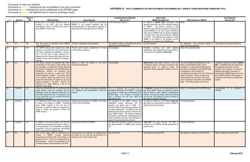
Comments in white are satisfied.<br />
Comments in orange background are not satisfied or are new comments.<br />
Comments in blue background can be addressed at the NFSSR stage.<br />
Comments in yellow are deferred due to need for hydrology model.<br />
APPENDIX A. TRCA COMMENTS ON SEATON MESPA DECEMBER 2011; MESPA TEAM RESPONSE FEBRUARY 2013<br />
# Section #<br />
Page # in<br />
PDF TRCA Comment Action Required<br />
45. 6.2 152 Some parts <strong>of</strong> the Iroquois Shoreline were not The Province needs to resolve this as prohibiting<br />
included in the NHS, and are therefore SWMFs in the Iroquois Shoreline may be<br />
developable; however, the CPDP policy does not counterproductive for water balance purposes as<br />
allow SWMFs in these areas.<br />
these may be the best opportunities to infiltrate.<br />
46. 6.2 152 How will erosion be prevented where SWMFs<br />
outlet to sandy soils?<br />
47. 6.2 152 The SWMF matrices <strong>of</strong>ten indicate that a water<br />
balance is not required for forest communities as<br />
the forest is supported by precipitation. However,<br />
this is not the case in many instances as it<br />
appears from the contours that forests are downgradient<br />
so they could be affected by changes in<br />
drainage.<br />
48. 6.2 153 This section includes the statement that “Minor<br />
modifications to the extent <strong>of</strong> these buffers may<br />
be acceptable, as determined through detailed,<br />
site specific investigations at the EIS/FSS stage <strong>of</strong><br />
development, although any reductions may<br />
necessitate the need for a permit from TRCA<br />
(Ontario Regulation 166/06).” The section needs<br />
to be revised to reflect the policies in the <strong>City</strong>’s<br />
Conformity Amendment with respect to uses and<br />
grading permitted in the NHS. Remove the<br />
reference to O. Reg. 166/06 as it will not be<br />
relevant in many cases.<br />
49. Table B6.1 154 There are concerns with the 7% preliminary pond<br />
sizing criterion. Given the uncertainty with the<br />
hydrologic model, the Regional assessment, and<br />
the erosion assessment, the 7% assumption may<br />
not be appropriate, and at a minimum should be<br />
verified with actual data.<br />
50. Table B6.1 154 The SWM plan details further study requirements<br />
in relation to the location <strong>of</strong> SWMFs. Illustrating<br />
exact SWMF locations at this time may be<br />
premature as specific studies (e.g. geotechnical,<br />
Hydro G, fluvial), are required to finalize the<br />
SWMF locations.<br />
51. Table B6.1 154 In addition to the above please note that the<br />
meander belt assessment discussed in Table 6.1<br />
is not appropriate in all circumstances. A detailed<br />
assessment using the appropriate methodology<br />
will be required at the subsequent phase.<br />
52. 6.3 158 One <strong>of</strong> the criteria used for determining the<br />
location <strong>of</strong> SWMFs included restricting<br />
encroachment to half the width <strong>of</strong> the linkage, or a<br />
minimum <strong>of</strong> 50 m. This is not in keeping with the<br />
NHS principles. There is no consideration <strong>of</strong> the<br />
cumulative impact <strong>of</strong> these facilities on the NHS.<br />
Provide an explanation and assessment.<br />
Provide water balance assessments for forest<br />
communities as necessary.<br />
Revise to reflect the policies in the <strong>City</strong>’s<br />
Conformity Amendment<br />
Complete a “test” using conservative assumptions<br />
(i.e. Regional control requirements) to verify this<br />
criterion.<br />
Update relevant sections <strong>of</strong> the MESP, and include<br />
in the ToR for the NFSSRs.<br />
Include in the ToR for the NFSSRs.<br />
As discussed at the meetings, the facilities should<br />
be located so as to limit their encroachment to a<br />
minimum <strong>of</strong> 25% <strong>of</strong> the corridor width.<br />
Consulting Team’s Response<br />
April 27, 2011<br />
Further discussion required.<br />
Action Taken<br />
MESPA December 2011<br />
As detailed in Section B6.2, discussions with<br />
agencies clarified the use <strong>of</strong> the Iroquois Shoreline<br />
for SWMFs. The direction provided is that<br />
justification and geotechnical support is required for<br />
locating SWMFs on the Lake Iroquois Shoreline.<br />
There are two SWMFs that are located completely<br />
or partially on the Lake Iroquois Shoreline: SWMFs<br />
14 and 30. The justification and support for these<br />
SWMFs to be located on the Shoreline will be<br />
discussed in more detail at the NFSSR stage.<br />
No action required.<br />
The design <strong>of</strong> outlets is site-specific and will be<br />
determined at the NFSSR stage.<br />
Acknowledged. Woodland screening and water balance<br />
assessments were undertaken and are reported in<br />
a new section <strong>of</strong> the MESPA, Section B9.<br />
Acknowledged.<br />
This is a standard ‘rule <strong>of</strong> thumb’ that is<br />
considered reasonable for the MESP. The need<br />
for a larger or smaller area is determined at the<br />
NFSSR stage. If an increase or decrease in<br />
area is required, this will occur within the<br />
development area.<br />
The approach to the SWMF matrices was<br />
established through discussions with the<br />
agencies and agreed upon in 2008. The<br />
matrices identify the general pond locations and<br />
not exact configuration. The MESP is clear that<br />
additional study will be required to determine the<br />
exact SWMF location. The matrices considered<br />
topographical, geotechnical, hydrogeological and<br />
fluvial information and other data necessary to<br />
support the general locations as shown.<br />
The table was intended to provide direction for<br />
the general location <strong>of</strong> SWMFs (see comment<br />
50).<br />
Section B6.2 makes explicit reference to the <strong>City</strong><br />
<strong>of</strong> <strong>Pickering</strong> Seaton Conformity Amendment and<br />
specifically policy 7.17 related to buffers; the<br />
reference to Ontario Regulation 166/06 is removed.<br />
In Table B6.1, it states that if detailed grading show<br />
that larger SWMF blocks are required, revisions<br />
may be made to pond locations/ configurations,<br />
however, all previously stated criteria and policies<br />
must be met. This clarifies the intent <strong>of</strong> wording in<br />
the column to the left in this table.<br />
The table <strong>of</strong> contents for the NFSSRs (Appendix<br />
J2) reflects the requirements for specific studies to<br />
identify specific pond locations.<br />
Table B6.1 has been removed. The table <strong>of</strong><br />
contents for the NFSSRs requires assessment <strong>of</strong><br />
meander belts.<br />
Noted.<br />
TRCA Comment on MESPA<br />
Not addressed. See comments related to<br />
erosion and small tributaries.<br />
Noted. See comments below.<br />
The text still states that “Modifications to the<br />
extent <strong>of</strong> these MESPA buffers may be<br />
acceptable, if so determined through detailed<br />
site specific investigations at the NFSSR stage<br />
<strong>of</strong> development, and must take into<br />
consideration the policies <strong>of</strong> the <strong>City</strong> <strong>of</strong> <strong>Pickering</strong><br />
Seaton Conformity”. We do not support the<br />
noted flexibility that is provided in the text to<br />
allow for changes to the buffers at the NFSSR<br />
stage. This wording needs to be removed.<br />
Team Response<br />
February 2013<br />
See response to Comment #28 above.<br />
Clarification has been provided in Section<br />
B6.2. The MESP study level determined<br />
the applicable buffer limits, with the<br />
exception <strong>of</strong> for wetlands. For wetlands,<br />
additional site-specific examination is<br />
required at the NFSSR stage and as such,<br />
for the MESPA SWMF matrix analysis, a<br />
conservative 30m buffer to wetlands was<br />
applied.<br />
Noted. To be addressed at the NFSSR stage. Acknowledged. To be addressed in<br />
NFSSRs.<br />
Comment addressed.<br />
Comment addressed.<br />
See comment 40. See response to comment #40. See response to response to comment #40. See the response to comment #40.<br />
PAGE 12 February 2013


