

Chapter A - Introduction - City of Pickering
Chapter A - Introduction - City of Pickering
Chapter A - Introduction - City of Pickering

Create successful ePaper yourself
Turn your PDF publications into a flip-book with our unique Google optimized e-Paper software.
Comments in white are satisfied.<br />
Comments in orange background are not satisfied or are new comments.<br />
Comments in blue background can be addressed at the NFSSR stage.<br />
Comments in yellow are deferred due to need for hydrology model.<br />
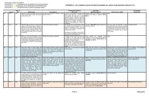
APPENDIX A. TRCA COMMENTS ON SEATON MESPA DECEMBER 2011; MESPA TEAM RESPONSE FEBRUARY 2013<br />
# Section #<br />
Page # in<br />
PDF TRCA Comment Action Required<br />
65. 7.6.3.1 180 Tables B7.9 and B7.10 contradict each other with We believe water balance is required for these<br />
respect to which wetlands require water balance, wetlands. Confirm.<br />
e.g. U2, U8, G12, G13.<br />
66. 7.6.3.1 183 Table B7.9 states that there is no specific water<br />
balance for UA4/5 because there is mitigation to<br />
upstream and downstream wetlands. However, it<br />
may not work this way and therefore further<br />
analysis is required. With respect to UB3-1, how<br />
can the catchment change if there is no proposed<br />
development?<br />
67. 7.6.3.2 184 Based on a review <strong>of</strong> the GIS database, some <strong>of</strong><br />
the Category B wetlands have been incorrectly<br />
categorized given development is proposed within<br />
the catchments. These include the wetland at D8-<br />
3, the wetland NE <strong>of</strong> SWMF #70, and the wetland<br />
east <strong>of</strong> WV1.<br />
68. 7.6.3.3 185 Table B7.10 states in several places that<br />
increased flow volumes will not be detrimental to<br />
the wetland functioning; however, an assessment<br />
<strong>of</strong> how this increased flow may impact on flooding<br />
and adjacent development is required. Similarly,<br />
increased volumes may also have implications on<br />
adjacent upland communities (e.g. W7-3, WV3:<br />
increased volumes may impact FOD7-2).<br />
69. 7.6.3.3 185 Table B7.10 states that there are a number <strong>of</strong><br />
wetlands where no water balance is required<br />
because the features are mainly groundwater-fed.<br />
However, the water balance assessment<br />
examined surface water contributions only. There<br />
needs to be a marriage between groundwater and<br />
surface water modeling to ensure that any<br />
recharge areas feeding these wetlands will be<br />
maintained. Changes in surface water<br />
contributions to these features may also affect<br />
water levels and should be considered.<br />
70. 7.6.3.3 191 It is stated in Table B7.10 with respect to U5 that<br />
a water balance is not required because this<br />
woodland and wetland will be largely impacted by<br />
a Brock Road realignment. However, due to the<br />
proposed revisions to the Hwy 407 interchanges,<br />
this wetland and woodland will no longer be<br />
impacted.<br />
71. 7.7.2 195 6 years <strong>of</strong> data is not appropriate for the feature<br />
based water balance assessment. Given the<br />
availability <strong>of</strong> data for the area, the assessment<br />
should include a larger data set and include more<br />
recent years <strong>of</strong> record.<br />
Provide further analysis or clarification.<br />
Reassess these wetlands as category D.<br />
Provide additional hydrologic analysis on flooding<br />
extents in areas where increased flow volumes are<br />
proposed, and provide an assessment <strong>of</strong><br />
implications to the developable area and adjacent<br />
vegetation communities.<br />
Provide both groundwater and surface water<br />
modeling analysis. Bring groundwater information<br />
together with monitoring data into one table,<br />
including geotechnical water level information.<br />
Provide a groundwater depth map. Look at the<br />
PRMS assessment locally, not globally, in areas<br />
where the wetlands are groundwater fed.<br />
Provide water balance for this wetland and<br />
woodland.<br />
Update assessment to include more relevant and<br />
larger data set.<br />
Consulting Team’s Response<br />
April 27, 2011<br />
In Table B7.9, the wetlands are identified by the<br />
reach on which they occur. In Table B7.10,<br />
other wetlands have been given a specific<br />
identification number. Therefore in Table B7.9,<br />
there are wetlands on Reach U2, Reach U8,<br />
Reach G12 and Reach G13. In Table B7.10, the<br />
references are to Wetland U2, Wetland U8,<br />
Wetland G12, and Wetland G13. There is no<br />
contradiction.<br />
The drainage area for the downstream wetland<br />
U9 includes the entire drainage area for the<br />
wetland on reachesUA4 and UA5. The water<br />
balance for U9 therefore encompasses the<br />
reaches on UA4 and UA5.<br />
With respect to the wetland on Reach UB3-1,<br />
there is proposed development in the catchment<br />
area (there is an error on Table B-7.9).<br />
The wetland on Reach D8-3 and the wetland NE<br />
<strong>of</strong> SWMF 70 on Reach DD4 do have<br />
developable area in their catchments and will be<br />
assessed as a Category D wetland.<br />
We believe you mean wetlands to the west and<br />
not east <strong>of</strong> WV1. These wetlands also have a<br />
small area <strong>of</strong> developable land within the<br />
catchment and will be assessed as a Category D<br />
wetland.<br />
Under review. To be discussed at upcoming<br />
technical meetings.<br />
The water balance for wetlands was surface<br />
water based (Qualhymo) where those wetlands<br />
are primarily sustained by surface water flows.<br />
For wetlands primarily sustained by groundwater<br />
flows, the impact analysis was addressed by the<br />
PRMS and Modflow. Further efforts to refine the<br />
presentation <strong>of</strong> the model results will be made<br />
and further discussion <strong>of</strong> the wetlands water<br />
sources will be provided. A depth to water table<br />
map will also be provided as noted in Comment<br />
7. With respect to the PRMS assessment, refer<br />
to response to Comment 14.<br />
Wetland and woodland water balance<br />
assessments will be completed.<br />
Revisions to datasets as discussed with TRCA<br />
will be used, and will include representative dry<br />
and wet years in consultation with the TRCA.<br />
Action Taken<br />
MESPA December 2011<br />
Additional clarifying text is added to the MESPA,<br />
explaining the naming <strong>of</strong> wetlands. (Section<br />
B8.3.3)<br />
The text in Table B8.8 (formerly Table B7.9) is<br />
clarified and corrected.<br />
These wetlands are reclassified having<br />
development in their surface catchment and are<br />
reassessed as required in Section B8.3.3.3 and<br />
Table B8.9 <strong>of</strong> the MESPA.<br />
Where peak flow controls are recommended,<br />
increased run<strong>of</strong>f volumes will not impact the extent<br />
<strong>of</strong> flooded areas.<br />
MESPA is revised and updated with regard to<br />
groundwater and wetlands and stream base flow, in<br />
Section B4.7.<br />
The MESPA is revised; see Section B8.3.3.3 and<br />
Table B8.9.<br />
Information provided in the MESPA is updated and<br />
explained. The same six years <strong>of</strong> data was used<br />
for the erosion assessment as well as the water<br />
balance assessments. See Section B5.9.3.<br />
Noted.<br />
TRCA Comment on MESPA<br />
The issue raised was pertaining to where<br />
stormwater will be outlet to the various wetlands<br />
undergoing water balance analysis and how this<br />
may change from one to the next. However, the<br />
resilience <strong>of</strong> the wetlands may not warrant<br />
further analysis.<br />
Noted.<br />
Similarly on page 173, it is identified that wetland<br />
U7 will not have a water balance, but it was felt<br />
that the additional water would expand and<br />
enhance the wetland. Also note that it will be<br />
impacted by Brock Road realignment. We are<br />
unsure whether there will be impacts to the<br />
future Brock Road works by adding water to this<br />
wetland? To be addressed at the NFSSR stage.<br />
This section indicates that there will still be a 7%<br />
change in groundwater contribution to wetlands<br />
and streams. Figure B4.20 indicates that<br />
drawdown will be as much as 4-5 m in some<br />
areas. These areas correspond to sensitive<br />
streams and wetlands. More work will need to<br />
be done at the NFSSR stage to further mitigate<br />
these impacts with LID measures. To be<br />
addressed at the NFSSR stage.<br />
Comment addressed.<br />
See Comment #32 related to the erosion<br />
assessment.<br />
Team Response<br />
February 2013<br />
No response required.<br />
To be addressed in the NFSSR for<br />
Neighbourhood 20.<br />
This has been addressed in the revised<br />
MESPA in Section B4.7.4.<br />
See the response to comment 32.<br />
PAGE 15 February 2013


