

Chapter A - Introduction - City of Pickering
Chapter A - Introduction - City of Pickering
Chapter A - Introduction - City of Pickering

Create successful ePaper yourself
Turn your PDF publications into a flip-book with our unique Google optimized e-Paper software.
RESPONSE TO CITY COMMENTS<br />
SWMF LOCATIONS<br />
(APPENDIX B)<br />
48<br />
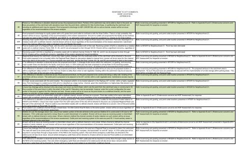
There is a 10m difference in elevation observed across the proposed pond block. Portions <strong>of</strong> the catchment may not be able to drain to the pond, as<br />
there are portions <strong>of</strong> the catchment with elevations lower than the pond block, additional On Site Control Areas, or partitioning the catchment and<br />
including an additional pond may be required. Pond proposed to discharge to HDF (HWDFC36) with no active channel, erosion will be an issue<br />
regardless <strong>of</strong> the recommendations <strong>of</strong> the erosion analysis.<br />
Refer to servicng and grading presented in NFSSR for Neighbourhood 20. Refer to Appendix B and C (Watercourse concerns and<br />
HDF Assessment) for response on erosion .<br />
49<br />
50A<br />
50B<br />
51<br />
54<br />
55<br />
56<br />
57<br />
58<br />
59<br />
60<br />
61<br />
62<br />
64<br />
65<br />
66<br />
67<br />
Pond proposed to discharge to a gully system with a 4% grade from pond outlet to confluence with the West Duffins. There is a high probability that Refer to servicing and grading, and pond outlet location presented in NFSSR for Neighbourhood 21.<br />
erosion will be an issue, regardless <strong>of</strong> the recommendations <strong>of</strong> the erosion assessment. Unsure if 2 outlets are proposed for the facility as the matrices<br />
indicates the need to feed 2 HWDF (HWDF36, and HWDF 8). An alternative outlet location should be considered (i.e. directly to the West Duffins).<br />
Directing major system flows from the north portion <strong>of</strong> the site may be an issue as a Regional Road bisects the catchment. Pond also discharges to a Refer to servicing and grading, and pond outlet location presented in NFSSR for Neighbourhood 21.<br />
meadow swale with no defined channel; channel erosion will be an issue regardless <strong>of</strong> the recommendations <strong>of</strong> the erosion assessment. Catchment<br />
area in the matrices differs from what is indicated in the Ach Reader Document.<br />
Pond is located south <strong>of</strong> a Regional Road, with the entire catchment area located north <strong>of</strong> the road. Receiving system (Wa16) is classified as a meadow Refer to NFSSR for Neighbourhood 21. Pond has been eliminated<br />
swale with no defined channel, Ponds 50B, 51, 60, and 61 are all proposed to drain through WA16. Erosion will be a significant concerns, regardless <strong>of</strong><br />
the erosion assessment recommendations.<br />
Receiving system (WA16) is classified as a meadow swale with no defined channel, Ponds 51, 50B, 60, and 61 are all proposed to drain through Refer to NFSSR for Neighbourhood 21. Pond has been eliminated<br />
WA16. Erosion will be a significant concerns, regardless <strong>of</strong> the erosion assessment recommendations.<br />
Regional Road bisects the catchment, unsure how major system drainage from the southwest portion <strong>of</strong> the catchment will be directed to the pond.<br />
Pond outlet proposed to be co-located within the Regional Road. Based on discussion related to channel form, erosion will be an issue for this channel<br />
due to the nature <strong>of</strong> the system (i.e. Course substrate over sand bed), and the fact that 3 ponds (64, 64, and 65) are proposed to drain to the system.<br />
A 7m difference in elevation is observed across the proposed pond block. A drainage divide occurs within the catchment, so grading, and ensuring Refer to servicng and grading presented in NFSSR for Neighbourhood 20.<br />
major system flows are directed to the facility could be an issue. A 100m outlet pipe has been proposed to convey flows to the receiving system.<br />
Proposed discharge point is highly vegetated, so getting maintenance access may be an issue. A sanitary trunk is proposed through the pond block.<br />
A 6m difference in elevation is observed across the proposed pond block. Maintenance access to outlet will be an issue as the proposed location is<br />
within a significant valley corridor (+/-10m from top <strong>of</strong> bank to valley floor) which is well vegetated. Grading within the catchment may be an issue as<br />
there is a high point at the mid point <strong>of</strong> the catchment.<br />
outlet will be co-located with the Regional Road.<br />
A 8m difference in elevation is observed across the proposed pond block, as the pond proposed to be constructed along a valley wall. Grading <strong>of</strong> the Refer to servicing and grading, and pond outlet location presented in NFSSR for Neighbourhood 21.<br />
pond block will be a concern. The outlet point is proposed to be adjacent to the 407 corridor within a well vegetated area; maintenance access may be<br />
an issue.<br />
No major issues associated with the pond location. The proposed outfall is to be located adjacent to the Highway 407 corridor, within a highly vegetated Refer to servicing and grading, and pond outlet location presented in NFSSR for Neighbourhood 21.<br />
area. Pond discharges to a watercourse DC6 which is classified as a deep narrow channel, given this classification it is highly likely that erosion is an<br />
existing issue. In addition Pond 59 is proposed to drain to the same system.<br />
Unsure how drainage will be directed to the site (major and minor) as North Road, which cuts the pond from the catchment area, is constructed in fill. Refer to servicing and grading, and pond outlet location presented in NFSSR for Neighbourhood 21.<br />
Also a portion <strong>of</strong> the pond block is within the extent <strong>of</strong> the road fill. Relocation may be warranted, however under the current configuration the west<br />
portion <strong>of</strong> the pond is against the 30m fisheries set back. Stream erosion will be an issue as the pond drains to a undefined channel, and the same<br />
system as pond 58. A trunk sanitary sewer is proposed adjacent to the pond block.<br />
Pond proposed to outlet to an intermittent swale with no defined channel, erosion will likely be a concern. Pond also outlets to the same intermittent Refer to Appendix B and C (Watercourse concerns and HDF Assessment) for response.<br />
system with no defined channel as pond’s 50B, 51, and 61, erosion will be an issue regardless <strong>of</strong> the recommendations <strong>of</strong> the erosion assessment.<br />
A 5m difference in elevation is observed across the proposed pond block. The pond is proposed to have 2 outlets for the purpose <strong>of</strong> water balance to Refer to servicing and grading, and pond outlet locations presented in NFSSR for Neighbourhood 21.<br />
HWDF2 and HWDF3. Unsure how major system from the north east portion <strong>of</strong> the site will be directed to the pond, as a proposed Regional Road cuts<br />
that part <strong>of</strong> the catchment <strong>of</strong>f. Pond to outlet to two intermittent swales with no defined channel, erosion will likely be a concern. One <strong>of</strong> the pond outlets<br />
is the same location as Pond 50B, 51 and 60.<br />
Pond outlets to an undefined channel through a forest block. On Site Control Area M drains to the same system, erosion will be an issue regardless <strong>of</strong><br />
the recommendations <strong>of</strong> the erosion assessment.<br />
Sideline 24 cuts the drainage area in two, unsure how western portion <strong>of</strong> the site will drain to the pond as Sideline 24 is constructed in fill (due to 407<br />
overpass). 170m outlet pipe required to convey flows to a point downstream <strong>of</strong> a wetland. Erosion will be an issue as receiving system is intermittent<br />
stream with no defined channel in some areas. Where channel is defined the channel consists <strong>of</strong> sandy material, as such erosion will be an issue<br />
regardless <strong>of</strong> the recommendations <strong>of</strong> the erosion assessment. Outlet point and receiving system is the same as pond 65. A trunk sanitary sewer is<br />
proposed adjacent to the pond block.<br />
Erosion will be an issue as receiving system is intermittent stream with no defined channel in some areas. Where channel is defined the channel<br />
consists <strong>of</strong> sandy material, as such erosion will be an issue regardless <strong>of</strong> the recommendations <strong>of</strong> the erosion assessment. Outlet point and receiving<br />
system is the same as pond 64.<br />
Unsure how drainage from the west portion <strong>of</strong> the catchment area will be directed to the pond as a Regional Road is proposed to bisect the catchment.<br />
The road will need to be constructed in fill in order to facilitate a Highway 407 overpass, and associated “on and <strong>of</strong>f” ramps. A 215m outlet pipe will be<br />
required to convey flows through a large section <strong>of</strong> the NHS to the receiving system. How and where emergency outlet flows are directed to the<br />
watercourse will also be an issue. Unsure where emergency outlet flows will be directed to. Erosion will be an issue as Pond outlets to an intermittent<br />
undefined channel.<br />
A 6m difference in elevation is observed across the proposed pond block. A 160m outlet pipe will be required to convey flows through a large section <strong>of</strong><br />
the NHS to the receiving system. How and where emergency outlet flows are directed to the watercourse will also be an issue. Unsure where<br />
emergency outlet flows will be directed to. Erosion will be an issue as pond outlets to an intermittent undefined channel.<br />
Refer to servicing and grading presented in NFSSR for Neighbourhood 21. Refer to Appendix B and C (Watercourse concerns and<br />
HDF Assessment) for response on erosion .<br />
Refer to servicng and grading presented in NFSSR for Neighbourhood 20. The proposed landuse in the catchment area is<br />
employment. As such the pond size can potentially be reduced with the implementation <strong>of</strong> on-site storage within parking areas. The<br />
Refer to Appendix B and C (Watercourse concerns and HDF Assessment) for response.<br />
Refer to servicing and grading presented in NFSSR for Neighbourhood 21. Refer to Appendix B and C (Watercourse concerns and<br />
HDF Assessment) for response on erosion .<br />
Refer to response to <strong>City</strong> Appendix B and C comments (Watercourse concerns and HDF Assessment) presented in Appendix B10-<br />
B <strong>of</strong> the MESPA.<br />
Refer to servicing and grading presented in NFSSR for Neighbourhood 21. Refer to Appendix B and C (Watercourse concerns and<br />
HDF Assessment) for response on erosion .<br />
Refer to servicing and grading presented in NFSSR for Neighbourhood 20. Refer to Appendix B and C (Watercourse concerns and<br />
HDF Assessment) for response on erosion .


