Chapter A - Introduction - City of Pickering
Chapter A - Introduction - City of Pickering
Chapter A - Introduction - City of Pickering
You also want an ePaper? Increase the reach of your titles
YUMPU automatically turns print PDFs into web optimized ePapers that Google loves.
Comments in white are satisfied.<br />
Comments in orange background are not satisfied or are new comments.<br />
Comments in blue background can be addressed at the NFSSR stage.<br />
Comments in yellow are deferred due to need for hydrology model.<br />
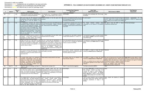
APPENDIX A. TRCA COMMENTS ON SEATON MESPA DECEMBER 2011; MESPA TEAM RESPONSE FEBRUARY 2013<br />
# Section #<br />
Page # in<br />
PDF TRCA Comment Action Required<br />
be shifted so that it is outside the NHS buffer.<br />
128. 7.1 1123 TRCA will need to view all new crossing locations<br />
in the field prior to finalizing the alignments.<br />
129. 7.1 1123 One parcel along the 407 employment lands<br />
located west <strong>of</strong> Brock Road immediately south <strong>of</strong><br />
the 407 has no road and appears to be<br />
landlocked.<br />
130. 7.1 1123 A comprehensive restoration plan should be<br />
developed for Seaton to address the impacts due<br />
to local road (and infrastructure) crossings. The<br />
impacts should be estimated at the MESP stage<br />
and clarified in detail at the NFSSR stage. The<br />
general location and area <strong>of</strong> restoration within the<br />
Seaton NHS should be identified. In some cases,<br />
restoration can take place on site. In others, this<br />
may not be possible and a restoration bank<br />
should be developed.<br />
131. 7.1.1 1123 Open bottom crossings should be provided for all<br />
crossings. If open bottom crossings are not<br />
appropriate for certain locations, then perhaps<br />
alternative locations should be evaluated.<br />
132. 7.1.1 1124 Please note that the 5 times bank full width<br />
approach to sizing water crossings is a planning<br />
tool only and only applies to a stable system. The<br />
5 times bank full may not be applicable for the<br />
sensitive reaches in Seaton.<br />
133. 7.1.1 1124 The minimum structural requirement from a fluvial<br />
perspective is to ensure the abutments <strong>of</strong> any<br />
watercourse crossing are located outside the 100<br />
year erosion limit.<br />
For information only. To be addressed at NFSSR<br />
stage. Site visit days should be set up well in<br />
advance.<br />
Provide information on how this parcel will be<br />
accessed.<br />
The Province as the owner <strong>of</strong> the NHS needs to be<br />
involved in this discussion. Prepare a restoration<br />
plan. Refine the plan at the NFSSR stage.<br />
Add a recommendation that open bottom culverts<br />
should be used for all crossings.<br />
Test the 5 times bank full generalization on a<br />
sensitive reach within Seaton to determine if it is<br />
appropriate to use everywhere. Perhaps it may be<br />
worthwhile to remove the 5 times bankfill criteria<br />
and focus on ensuring the appropriate criterion is in<br />
place for the NFSSRs. Detailed fluvial<br />
assessments will be required for all crossings at the<br />
NFSSR stage.<br />
Please ensure the minimum structural requirements<br />
are included in the criteria.<br />
Consulting Team’s Response<br />
April 27, 2011<br />
-requires further discussion<br />
Acknowledged.<br />
As shown in the Neighbourhood Plan, the parcel<br />
will be accessed by a local road from the east,<br />
connecting to Old Brock Road.<br />
A comprehensive restoration plan will not be<br />
prepared. No compensation is proposed for<br />
non-Regional roads through the NHS that were<br />
in the CPDP.<br />
The requirement for open bottom crossings is<br />
currently noted is Sections C7.1.1 and C7.1.2.<br />
The 5 times bankfull criteria will be removed and<br />
the focus will be on ensuring the appropriate<br />
criterion is in place for the NFSSR.<br />
The minimum structural requirements were<br />
mentioned in the text but not explicitly as criteria.<br />
This will be added to the criteria.<br />
Action Taken<br />
MESPA December 2011<br />
Site walks will be coordinated with TRCA through<br />
the NFSSRs.<br />
No action required.<br />
The Roads Checklist indicates where<br />
compensation will be required for non-Regional<br />
roads.<br />
This requirement is provided in the Road Checklist<br />
table, detailed in <strong>Chapter</strong> C, and will be completed<br />
at the NFSSR stage.<br />
The requirement to determine this is detailed in the<br />
Roads Checklist (see Section C6.4.2 and Table<br />
C6.13).<br />
The MESPA is revised to include the Roads<br />
Checklist (see Section C6.4.2 and Table C6.13).<br />
Noted.<br />
TRCA Comment on MESPA<br />
An access is now shown in the land use layer on<br />
the pmf. Details for this crossing, as with the<br />
other crossings, will be required at the NFSSR<br />
stage.<br />
We need to meet with MNR to discuss<br />
comprehensive restoration plan.<br />
Noted.<br />
Addressed.<br />
Addressed.<br />
Team Response<br />
February 2013<br />
Comments acknowledged. To be<br />
addressed in NFSSR for Neighbourhood<br />
20.<br />
Comment acknowledged.<br />
134. 7.1.1 1124 A crossing criteria needs to be developed for<br />
intermittent channels/swales where the flow<br />
regime may change under post development<br />
conditions. For example, it is likely that existing<br />
intermittent watercourses may flow permanently<br />
under post development conditions due to<br />
extended inputs from SWMFs.<br />
135. Table C7.1 1125 Figure C3.1 refers to 37 crossings, yet Table C7.1<br />
refers to only 31.<br />
136. 7.1.2 1127 Ecopassages are required for all NHS crossings,<br />
not only at the locations where a watercourse<br />
exists. No information has been provided for the<br />
location and number <strong>of</strong> ecopassages. Evaluation<br />
is required as part <strong>of</strong> the Terms <strong>of</strong> Reference.<br />
137. 7.1.2 1127 The crossing criteria for roads need to be outlined<br />
at the MESP stage. The design parameters for<br />
each structure should be laid out, i.e. what are the<br />
factors driving the sizes <strong>of</strong> the structures? This<br />
includes ecopassages where no watercourse<br />
exists. Criteria that would apply in the fullness <strong>of</strong><br />
time as the NHS renaturalizes need to be<br />
Please develop crossing criteria for such cases.<br />
The required criteria will be indicated in the<br />
Roads Checklist, <strong>Chapter</strong> C.<br />
The MESPA is revised to include the Roads<br />
Checklist (see Section C6.4.2 and Table C6.13).<br />
Further, it is clarified that any channel that has<br />
been identified, regardless <strong>of</strong> its flow regime, will be<br />
addressed.<br />
Please document crossings 16-21. Table C7.1 was removed as suggested. The Table is removed from MESPA. Noted.<br />
Identify generally where and how many<br />
ecopassages are needed, and a framework for how<br />
large they should be. Provide this information on a<br />
map. Details <strong>of</strong> the ecopassages can be provided<br />
at the NFSSR stage.<br />
Provide the criteria that need to be considered for<br />
each crossing, including wildlife passage,<br />
vegetation communities, aquatic, geomorphic,<br />
hydraulics, trails, etc. Details <strong>of</strong> the crossing<br />
design can be provided at the NFSSR stage.<br />
Acknowledged.<br />
Acknowledged.<br />
A new figure, Figure C6.2, is provided showing all<br />
NHS crossings. Direction for design <strong>of</strong> all<br />
crossings with regard to wildlife passage is<br />
provided in the Road Checklist. See Section<br />
C6.4.2, Table C6.13. Details <strong>of</strong> crossing designs<br />
including wildlife passage will be provided in the<br />
NFSSRs.<br />
There is a Road Checklist for each non-Regional<br />
Road NHS crossing which identifies criteria and<br />
assessment requirements for design in the<br />
NFSSRs.<br />
We could not locate the text in this section that<br />
speaks to addressing this issue. Please provide<br />
additional detail, and clarify what is meant by<br />
“formalizing the channel” in regards to channels<br />
where is it not possible to avoid fine sediment<br />
banks and vegetation control (under Fluvial<br />
Geomorphology criteria in Table C6.13).<br />
Noted.<br />
Noted, however see response to Comment<br />
#134.<br />
Table C6.13 has been edited to include:<br />
references to intermittent channels swales;<br />
and, clarification with regard to ‘formalizing<br />
the channel’.<br />
PAGE 32 February 2013


