

Chapter A - Introduction - City of Pickering
Chapter A - Introduction - City of Pickering
Chapter A - Introduction - City of Pickering

You also want an ePaper? Increase the reach of your titles
YUMPU automatically turns print PDFs into web optimized ePapers that Google loves.
Comments in white are satisfied.<br />
Comments in orange background are not satisfied or are new comments.<br />
Comments in blue background can be addressed at the NFSSR stage.<br />
Comments in yellow are deferred due to need for hydrology model.<br />
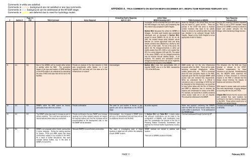
APPENDIX A. TRCA COMMENTS ON SEATON MESPA DECEMBER 2011; MESPA TEAM RESPONSE FEBRUARY 2013<br />
# Section #<br />
Page # in<br />
PDF TRCA Comment Action Required<br />
41. 6.2 152 Most <strong>of</strong> the SWMFs will be located either wholly<br />
or partially within the NHS. The cumulative<br />
impact <strong>of</strong> the type and location <strong>of</strong> SWM facilities<br />
on the NHS needs to be understood by calculating<br />
the area <strong>of</strong> NHS land base that will be lost to the<br />
facilities.<br />
42. 6.2 152 SWMFs within the NHS cannot be fenced,<br />
particularly those within the corridors.<br />
43. 6.2 152 The SWMF sizing may need to increase as part <strong>of</strong><br />
refined modeling. This could have implications on<br />
natural features where sites are constrained.<br />
44. 6.2 152 SWMFs are proposed within thicket communities<br />
in some instances. During the staking exercise<br />
for Seaton, TRCA and MNR stated that these<br />
communities needed to be included in the NHS.<br />
As a result <strong>of</strong> further discussions, they were<br />
included without buffers, e.g. in the area <strong>of</strong><br />
SWMFs #12 and #16.<br />
Provide an analysis <strong>of</strong> the total reduction in NHS<br />
area proportionally within Seaton, i.e. it was<br />
originally 53% and what will it be when all <strong>of</strong> the<br />
infrastructure is in place?<br />
Provide confirmation.<br />
Provide confirmation that any SWMF size increase<br />
resulting from further detailed analysis will respect<br />
the required buffers such that the increases will be<br />
accommodated on the development side, or that<br />
the SWMF will be relocated.<br />
Relocate SMWFs to avoid thicket communities.<br />
Acknowledged.<br />
Consulting Team’s Response<br />
April 27, 2011<br />
The need for and location <strong>of</strong> fences is sitespecific<br />
and will be determined at the NFSSR<br />
stage.<br />
Acknowledged. Any increased in SWMF block<br />
will occur on development land and there will be<br />
no additional intrusion into the NHS.<br />
The .team is investigating each <strong>of</strong> these<br />
locations in detail and will confirm the suitability<br />
<strong>of</strong> each SWMF location.<br />
Action Taken<br />
MESPA December 2011<br />
In principle, we do not accept that up to 50% use <strong>of</strong><br />
the NHS linkage is too much, and considering that<br />
this criterion was accepted in Duffin Heights.<br />
Section B6.3 discusses the criteria for SWMFs in<br />
linkages. As noted, each location was considered<br />
individually and, as discussed in Section B6.3,<br />
except for seven SWMFs (18, 20, 22, 35, 44, 49,<br />
50A), the created linkage areas between natural<br />
features (i.e. across agricultural land) and along<br />
stream corridors were affected by a facility by less<br />
than 25% <strong>of</strong> their width. For two <strong>of</strong> the seven, the<br />
extent into the linkage/connectivity is either just<br />
slightly greater than 25% (#49) or only greater than<br />
25% for a short distance (#18 and 35). The extent<br />
<strong>of</strong> the seven SWMFs into the linkage/connectivity<br />
may be reduced through detailed design. In all<br />
locations, the existing and anticipated corridor<br />
linkage/connectivity functions will not be negatively<br />
impacted by the locations <strong>of</strong> the SWMFs.<br />
Section B6.2 notes that approximately 26% <strong>of</strong><br />
required SWMF area is in the NHS, representing<br />
1.3% <strong>of</strong> the NHS area.<br />
No action required.<br />
In Section B6.2 and Table B6.1 it clearly states<br />
that although modifications can be made to the<br />
configuration <strong>of</strong> SWMFs, such modification must<br />
take into consideration the policies <strong>of</strong> the <strong>City</strong> <strong>of</strong><br />
<strong>Pickering</strong> Seaton Conformity Amendment, and<br />
explicitly the minimum buffer requirements <strong>of</strong> policy<br />
7.17.<br />
SWMF matrices are revised to address each<br />
location.<br />
There are no SWMFs located in thickets.<br />
TRCA Comment on MESPA<br />
driven by changes in the school block and was<br />
only the result <strong>of</strong> 1 pond, not 60+. There are<br />
policies in the CPDP that strive to maintain<br />
corridor functions that need to be upheld.<br />
Seaton is striving for something better than what<br />
was intended to be achieved through Duffin<br />
Heights. Based on this, Duffin Heights is not an<br />
appropriate model for Seaton.<br />
SWM ponds are not the only infrastructure<br />
proposed within the NHS. There will be roads,<br />
servicing, municipal infrastructure, utilities,<br />
outfalls, garden plots, etc. TRCA is concerned<br />
about the total cumulative impact on the NHS,<br />
especially given that the municipal SWMF outfall<br />
access road and overland flow requirements.<br />
While we understand that it is difficult to<br />
calculate an area or percentage <strong>of</strong> NHS that will<br />
be impacted by this infrastructure, we would like<br />
to have further dialog with the <strong>City</strong> <strong>of</strong> <strong>Pickering</strong><br />
and MNR to determine how to minimize the<br />
impacts and compensate for losses to the NHS.<br />
For example, we would like to solidify scenarios<br />
where access roads are or are not required.<br />
This should be referenced in the MESP.<br />
Action was required, confirming that SWMFs<br />
within the NHS will not be fenced unless where<br />
public safety is paramount. To be addressed at<br />
the NFSSR stage.<br />
Comment addressed through Conformity OP.<br />
Noted.<br />
Team Response<br />
February 2013<br />
that the 25% maximum intrusion requested<br />
by TRCA is not a CPDP mandate, these<br />
seven (<strong>of</strong> 57) SWMFs continue to extend to<br />
lesser and greater amounts into the<br />
linkage, while maintaining linkage function.<br />
The intrusions into the NHS are those<br />
directed or allowed by the CPDP.<br />
Therefore compensation for these<br />
intrusions is not required. Notwithstanding<br />
this, the MESPA either examined the<br />
locations <strong>of</strong> these intrusions to minimize<br />
impacts to the NHS or directed that the<br />
design should minimize the impacts to<br />
features and functions <strong>of</strong> the NHS.<br />
With regard to access roads and overland<br />
flow route requirements, on-going dialogue<br />
is occurring with the <strong>City</strong> and TRCA.<br />
<strong>Chapter</strong> B6.4 directs that the access road<br />
and overland flow route locations be<br />
confirmed in the field to minimize impacts<br />
to the NHS. These actions would occur at<br />
NFSSRs and detailed design.<br />
Comment acknowledged. To be addressed<br />
in NFSSRs.<br />
PAGE 11 February 2013


