

Chapter A - Introduction - City of Pickering
Chapter A - Introduction - City of Pickering
Chapter A - Introduction - City of Pickering

You also want an ePaper? Increase the reach of your titles
YUMPU automatically turns print PDFs into web optimized ePapers that Google loves.
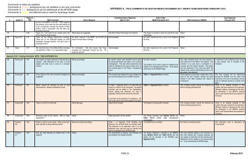
Comments in white are satisfied.<br />
Comments in orange background are not satisfied or are new comments.<br />
Comments in blue background can be addressed at the NFSSR stage.<br />
Comments in yellow are deferred due to need for hydrology model.<br />
APPENDIX A. TRCA COMMENTS ON SEATON MESPA DECEMBER 2011; MESPA TEAM RESPONSE FEBRUARY 2013<br />
# Section #<br />
Page # in<br />
PDF TRCA Comment Action Required<br />
Consulting Team’s Response<br />
April 27, 2011<br />
Action Taken<br />
MESPA December 2011<br />
be part <strong>of</strong> the MESP or the EA? TRCA supports<br />
the removal <strong>of</strong> this road from the road network as<br />
it will, cumulatively, increase the impacts to West<br />
Duffins creek in association with the other two<br />
proposed crossings.<br />
145. 1138 Figure C1.7 will need to be revised given the Revise figure as suggested. New Brock Road interchange now finalized. The Figure is revised to show the new Brock road<br />
Huron-Wendat village location.<br />
interchange.<br />
146. Figure C3.1 1141 There are two missing watercourse crossings. No action required in the MESP, but the EA will Acknowledged.<br />
No action required as this is part <strong>of</strong> the Regional<br />
These are on the Whitevale bypass on small need to include these crossings.<br />
EA work.<br />
headwater drainage features, one each west <strong>of</strong><br />
crossings G and I.<br />
Noted.<br />
Noted.<br />
TRCA Comment on MESPA<br />
Team Response<br />
February 2013<br />
147. Table 1 1177 We note that none <strong>of</strong> the West Duffins crossings<br />
are identified in Table 1 or on associated maps.<br />
For information. We will ensure that these<br />
crossings are addressed through the EA. No<br />
response required.<br />
Acknowledged.<br />
No action required as this is part <strong>of</strong> the Regional<br />
EA work.<br />
Noted.<br />
Appendix C3-B - Crossing Constraints NOTE: THIS IS APPENDIX C6-A<br />
148. Crossing #3 1181 The location <strong>of</strong> seeps observed in field should be<br />
mapped. Shift alignment to the north to avoid<br />
swales and trees and to cross at a narrower<br />
location.<br />
149. Crossing #4 1181 Cross further to the north to avoid the diagonal as<br />
suggested.<br />
150. Crossing #7 1181 Barrier should be removed as part <strong>of</strong> road<br />
improvements. Butternut identified to south.<br />
Revise accordingly.<br />
Revise accordingly.<br />
Revise accordingly.<br />
No specific seeps were identified during either<br />
the geomorphological site walks or the crossing<br />
investigations. The area where watercress was<br />
noted is indicated by the ground photo arrow on<br />
the Crossing figure in the Phase 1 Background<br />
report.<br />
The crossing was diagonal but was realigned as<br />
per recommendations prior to MESP issuance.<br />
In Table 1, Appendix C3-B, it is noted that the<br />
culvert is a barrier to fish movement. An explicit<br />
comment can be added in the ‘Implications’<br />
column stating that whenever the road is<br />
upgraded, that the barrier should be removed.<br />
No action required.<br />
The location <strong>of</strong> the road is based on detailed work<br />
related to the Neighbourhood Plans. Final design<br />
will be done at the NFSSR stage.<br />
Table 1 in Appendix C6-A is revised.<br />
Table 1 in Appendix C6-A is revised.<br />
The roads checklist shows the road crossing a<br />
fairly wide part <strong>of</strong> the NHS in the wetland. Our<br />
comment to try and move it northward to a<br />
narrower spot still seems relevant. We expect<br />
that the placement <strong>of</strong> the road bed within the<br />
wetland area could be detrimental yet this is not<br />
discussed in the checklist.<br />
There appears to have been a slight skew <strong>of</strong> this<br />
road on the pmf, however nothing has been<br />
revised in the table indicated with regard to<br />
Crossing #4.<br />
This crossing location should be removed as<br />
there is nothing proposed here.<br />
A comment re the presence <strong>of</strong> a butternut, ~60-<br />
70m south <strong>of</strong> the road, will be added to the table.<br />
151. Crossing #8 1182 There is no ELC for north side. Clarify data gap. Figure will be revised. The Figure for Crossing #8 is revised. This crossing location should be removed as<br />
there is nothing proposed here.<br />
152. Crossing #9 1182 Bobolinks noted at this location. What is “edge<br />
preparation”?<br />
153. Crossing<br />
#10<br />
154. Crossing<br />
#11<br />
1182 Widen to west to avoid marsh. What is the eastwest<br />
road that is being referenced here?<br />
1182 How will road drainage be treated next to the<br />
wetland?<br />
Clarify. Edge preparation will be clarified. The Roads Checklist (see Section C6.4.2 and<br />
Table C6.13) details edge management<br />
requirements.<br />
Revise and clarify accordingly.<br />
Clarify.<br />
Table 1 <strong>of</strong> Appendix C3-B identifies that<br />
Crossing 10 is at North Road, (an existing road).<br />
The reference to an east-west road is to an<br />
additional local road that may be required and<br />
will be investigated at the NFSSR stage.<br />
The requirement to address road drainage will<br />
be included in the Roads Checklist.<br />
Noted.<br />
A reference to this wetland and the issues<br />
it may present now is included in the<br />
Checklist.<br />
The final crossing will be determined<br />
through the NFSSR, and any ‘skew’ that<br />
may show in the pmf is conceptual, and as<br />
such no reference should or is made in the<br />
table.<br />
There is an existing crossing in this<br />
location that was required to be examined.<br />
Although nothing is proposed at this time,<br />
the information in the MESPA remains<br />
valid if road improvements are proposed in<br />
the future.<br />
There is an existing crossing in this<br />
location that was required to be examined.<br />
Although nothing is proposed at this time,<br />
the information in the MESPA remains<br />
valid if road improvements are proposed in<br />
the future.<br />
The MESPA text is clarified. No mention <strong>of</strong> avoiding marsh. The east-west road is discussed as<br />
Crossing #25.<br />
The Roads Checklist is included in the MESPA<br />
(see Section C6.4.2 and Table C6.13) and the<br />
details will be provided in the NFSSRs (see<br />
Appendix C6-C).<br />
The road checklist speaks to the removal <strong>of</strong> a<br />
dam and existing farm crossing upstream but<br />
only speaks to restoration for the crossing itself.<br />
Restoration will be needed in the removal areas<br />
too. To be implemented at NFSSR stage.<br />
PAGE 34 February 2013


