

Chapter A - Introduction - City of Pickering
Chapter A - Introduction - City of Pickering
Chapter A - Introduction - City of Pickering

Create successful ePaper yourself
Turn your PDF publications into a flip-book with our unique Google optimized e-Paper software.
Comments in white are satisfied.<br />
Comments in orange background are not satisfied or are new comments.<br />
Comments in blue background can be addressed at the NFSSR stage.<br />
Comments in yellow are deferred due to need for hydrology model.<br />
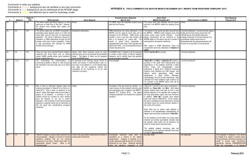
APPENDIX A. TRCA COMMENTS ON SEATON MESPA DECEMBER 2011; MESPA TEAM RESPONSE FEBRUARY 2013<br />
# Section #<br />
Page # in<br />
PDF TRCA Comment Action Required<br />
53. 6.4 158 This section states that feature staking is to take Revise.<br />
place prior to Draft Plan or Site Plan. However,<br />
the features have already been staked and<br />
surveyed.<br />
54. 6.9 159 This section states that “all SWMF constructed in Evaluate the alternatives.<br />
permeable sandy deposits and/or at or within the<br />
water table must be lined with an impermeable<br />
geotextile.” The Terms <strong>of</strong> Reference requires an<br />
evaluation <strong>of</strong> SWM alternatives through the EA<br />
process, which has not been completed. If there<br />
is high groundwater then perhaps the SWM<br />
facilities can be relocated.<br />
55. 6.9 159 There are many more potential thermal mitigation<br />
measures than those listed, such as cooling<br />
towers, GEMS, planted berms, pond orientation,<br />
length to width ratios, etc.<br />
56. 7.2.3 161 The methodology for instrumentation for<br />
monitoring purposes is difficult to verify because<br />
the information may have been part <strong>of</strong> an earlier<br />
report.<br />
57. 7.2.4 163 Why is there no distinction between deep and<br />
shallow groundwater in Table B7.2 but there is in<br />
Table B7.1? Why is there no reference to the<br />
datum? Water level depths should be provided in<br />
graphs for all wetlands. A summary <strong>of</strong> each<br />
wetland should be provided for each wetland<br />
given the analysis, i.e. s/w, g/w or combodependent.<br />
We would like to see monitoring data<br />
graphed so seasonal trends can be discerned as<br />
this will assist with understanding ecological<br />
tolerances.<br />
Specify when these measures would be used,<br />
otherwise they will not be proposed during detailed<br />
design. The details <strong>of</strong> these can be prepared<br />
during the NFSSR stage.<br />
As discussed at the meetings, please confirm the<br />
number and location <strong>of</strong> instrumentation used (i.e.<br />
how many in the wetland vs. on the wetland edge;<br />
how deep did the equipment extend) and<br />
consolidate all the monitoring for all the data<br />
collected in one place.<br />
Clarify.<br />
Consulting Team’s Response<br />
April 27, 2011<br />
The MESP team has requested original survey<br />
data from the Province.<br />
SWM alternatives are being addressed in the<br />
MESPA and the need for pond liners will be<br />
evaluated at the NFSSRS. SWM ponds are<br />
located in such a way than they function with<br />
little or no pumping (i.e., gravity fed). This<br />
results in ponds being constructed in<br />
topographically lower areas, which typically have<br />
higher water table. It is not practical/functional to<br />
relocate required ponds.<br />
The MESPA text in <strong>Chapter</strong> B will be expanded<br />
to include a wider variety <strong>of</strong> thermal mitigation<br />
measures, and to identify those that generally<br />
would be applied universally.<br />
Acknowledged.<br />
The tables in the text should be clarified. It is<br />
noted, however, that the wetland monitoring data<br />
and hydrographs were included in the MESP in<br />
Appendix B-7 (Figures B7-b). The graphs<br />
included precipitation and illustrate the seasonal<br />
variations<br />
Action Taken<br />
MESPA December 2011<br />
The survey limits were obtained, and the figures<br />
and text in the MESPA reflect the existing survey<br />
data.<br />
The direction to line ponds has been removed from<br />
the MESPA. MESPA model analyses show that<br />
unlined ponds would benefit infiltration. Pond<br />
design requirements will be confirmed at the<br />
NFSSR stage (i.e. the need to line all or a portion <strong>of</strong><br />
pond based on site specific conditions).<br />
With respect to SWM alternatives. Class EA<br />
requirements have been addressed in <strong>Chapter</strong>s A<br />
and B.<br />
MESPA Section B6.4 is revised.<br />
Tables B8.1 and B8.2 in Appendix B7 present a<br />
summary <strong>of</strong> the water level measurements and<br />
observations in the wetlands monitored in West<br />
Duffins Creek and Ganatsekiagon Creek<br />
watersheds. In March 2011, additional monitoring<br />
locations were identified and staff gauges, flow<br />
stations and/or piezometers nests were<br />
implemented in West Duffins, Whitevale,<br />
Ganatsekiagon and Urfe Creeks watersheds. Data<br />
collected from these additional eight locations are<br />
not included in this MESPA report; they will be<br />
reported in the NFSSRs.<br />
Tables B7.1 and B7.2 have been renumbered in<br />
MESPA as Tables B8.1 and B8.2. Both tables<br />
present shallow water level data as this is most<br />
relevant adjacent to the wetlands and is aspect <strong>of</strong><br />
the local groundwater regime that was monitored.<br />
In addition, Table B8.1 includes some deeper<br />
water level data for WSS-WD-01. At this location,<br />
the data is available and was presented to provide<br />
information about the vertical hydraulic gradient in<br />
the vicinity <strong>of</strong> this station.<br />
Since there are no similar nests adjacent to<br />
wetlands in the Ganatsekiagon subwatershed, No<br />
deeper water level data is presented in Table B8.2.<br />
Noted.<br />
TRCA Comment on MESPA<br />
Comment addressed. In event that other agency<br />
bodies wish to have certain ponds lined, the<br />
NFSSR reports must identify alternative<br />
mitigation measures. For those instances, the<br />
groundwater model must be rerun to<br />
demonstrate that the proposed measures will<br />
function to an equivalent <strong>of</strong> unlined ponds.<br />
Comment addressed.<br />
Comment addressed.<br />
Comment addressed.<br />
Team Response<br />
February 2013<br />
For the wetlands on both tables, the surface water<br />
elevation and shallow groundwater elevation data<br />
are geodetic water levels and all elevations are<br />
shown as metres above sea level (masl).<br />
58. 7.2 167 Table B7.3 speaks to surface water catchment but<br />
not groundwater. Category A should not include<br />
valleyland wetlands that are not primary<br />
influenced by river flows. Please clarify what “not<br />
substantially altered” means. What is the<br />
threshold used?<br />
Confirm that groundwater catchments are similar to<br />
surface water catchments<br />
Groundwater catchment areas were not<br />
considered as a criterion in the wetland<br />
categorization. Category A wetlands do not<br />
include valleyland wetlands that are not primarily<br />
influenced by river flows: Palustrine wetlands<br />
and/or the palustrine component <strong>of</strong> the<br />
The updated wetland monitoring data and<br />
hydrographs for all monitored wetlands have been<br />
included in Appendix B8-B.<br />
No action taken. Not addressed. The evaluation <strong>of</strong> wetlands in this section<br />
<strong>of</strong> <strong>Chapter</strong> B is related to surface water.<br />
The groundwater catchments generally are<br />
similar to surface water catchments.<br />
Specifically, however, PRMS/MODFLOW<br />
dealt with groundwater to all features,<br />
PAGE 13 February 2013


