

Chapter A - Introduction - City of Pickering
Chapter A - Introduction - City of Pickering
Chapter A - Introduction - City of Pickering

You also want an ePaper? Increase the reach of your titles
YUMPU automatically turns print PDFs into web optimized ePapers that Google loves.
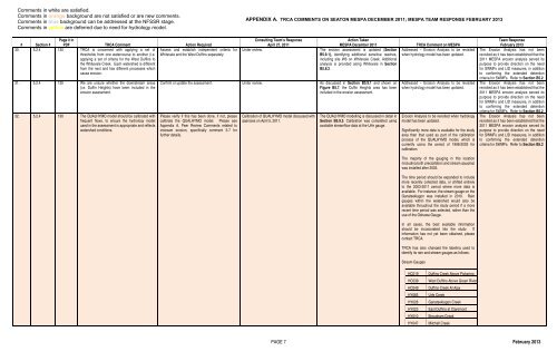
Comments in white are satisfied.<br />
Comments in orange background are not satisfied or are new comments.<br />
Comments in blue background can be addressed at the NFSSR stage.<br />
Comments in yellow are deferred due to need for hydrology model.<br />
APPENDIX A. TRCA COMMENTS ON SEATON MESPA DECEMBER 2011; MESPA TEAM RESPONSE FEBRUARY 2013<br />
# Section #<br />
Page # in<br />
PDF TRCA Comment Action Required<br />
30. 5.2.4 130 TRCA is concerned with applying a set <strong>of</strong> Assess and establish independent criteria for<br />
thresholds from one watercourse to another (i.e. Whitevale and the West Duffins separately.<br />
applying a set <strong>of</strong> criteria for the West Duffins to<br />
the Whitevale Creek. Each watershed is different<br />
from the next and has different processes which<br />
cause erosion.<br />
31. 5.2.4 130 We are unsure whether the downstream areas<br />
(i.e. Duffin Heights) have been included in the<br />
erosion assessment.<br />
32. 5.2.4 130 The QUALHYMO model should be calibrated with<br />
frequent flows, to ensure the hydrology model<br />
used in the assessment is appropriate and reflects<br />
watershed conditions.<br />
Consulting Team’s Response<br />
April 27, 2011<br />
Under review.<br />
Action Taken<br />
MESPA December 2011<br />
The erosion assessment is updated (Section<br />
B5.9.1), identifying additional sensitive reaches,<br />
including site W6 on Whitevale Creek. Additional<br />
analysis is provided along Whitevale in Section<br />
B5.8.2.<br />
Confirm or update the assessment. Under review. As discussed in Section B5.9.1 and shown on<br />
Figure B5.7, the Duffin Heights area has been<br />
included in the erosion assessment.<br />
Please verify if this has been done, if not, please<br />
calibrate the QUALHYMO model. Please see<br />
Appendix A, Peer Review Comments related to<br />
instream erosion, specifically comment 3-7 for<br />
further details.<br />
Calibration <strong>of</strong> QUALHYMO model discussed with<br />
agencies on April 5, 2011.<br />
The QUALHYMO modelling is discussed in detail in<br />
Section B5.9.3. Calibration was completed using<br />
available streamflow data at the Urfe gauge.<br />
TRCA Comment on MESPA<br />
Addressed – Erosion Analysis to be revisited<br />
when hydrology model has been updated.<br />
Addressed – Erosion Analysis to be revisited<br />
when hydrology model has been updated.<br />
Erosion Analysis to be revisited when hydrology<br />
model has been updated.<br />
Significantly more data is available for the study<br />
area than that used as part <strong>of</strong> the calibration<br />
process <strong>of</strong> the QUALHYMO model, which is<br />
currently using the period <strong>of</strong> 1998-2003 for<br />
calibration.<br />
The majority <strong>of</strong> the gauging in this location<br />
(including both precipitation and stream gauging)<br />
was installed after 2003.<br />
The time period should be expanded to include<br />
more recently collected data, or shifted entirely<br />
to the 2003-2011 period where more data is<br />
available. For instance, the stream gauge on the<br />
Ganatsekiagon was installed in 2010. Rain<br />
gauges within the watershed would also be<br />
available throughout the study period if a more<br />
recent time period was selected, rather than the<br />
use <strong>of</strong> the Oshawa Gauge.<br />
In all cases, the best available information<br />
should be incorporated into the study. If<br />
information has not yet been obtained, please<br />
contact TRCA.<br />
TRCA has also changed the labeling used to<br />
identify its rain and stream gauges as follows:<br />
Stream Gauges<br />
Team Response<br />
February 2013<br />
The Erosion Analysis has not been<br />
revisited as it has been established that the<br />
2011 MESPA erosion analysis served its<br />
purpose to provide direction on the need<br />
for SWMFs and LID measures, in addition<br />
to confirming the extended detention<br />
criteria for SWMFs. Refer to Section B5.2<br />
HC019<br />
HC038<br />
HC049<br />
HY065<br />
HY028<br />
HY023<br />
HY010<br />
HY047<br />
Duffins Creek Above <strong>Pickering</strong><br />
West Duffins Above Green River<br />
Duffins Creek At Ajax<br />
Urfe Creek<br />
Ganatsekiagon Creek<br />
East Duffins at Claremont<br />
Brougham Creek<br />
Mitchell Creek<br />
PAGE 7 February 2013


