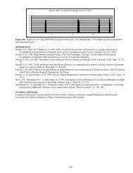
Impact Of Host Plant Xylem Fluid On Xylella Fastidiosa Multiplication ...
Impact Of Host Plant Xylem Fluid On Xylella Fastidiosa Multiplication ...
Impact Of Host Plant Xylem Fluid On Xylella Fastidiosa Multiplication ...

You also want an ePaper? Increase the reach of your titles
YUMPU automatically turns print PDFs into web optimized ePapers that Google loves.
SPATIAL DATABASE CREATION AND MAINTENANCE FOR PIERCE’S DISEASE AND<br />
GLASSY-WINGED SHARPSHOOTER IN CALIFORNIA<br />
Project Leader:<br />
Maggi Kelly<br />
Dept. of Environmental Science, Policy, & Management<br />
University of California<br />
Berkeley, CA 94720<br />
Reporting Period: The results reported here are from work conducted from July 1, 2004 to October 1, 2004.<br />
INTRODUCTION<br />
Whether tracking invasive species, assessing water quality, or monitoring the spread of disease, comprehensive data<br />
collection is a key component of scientific inquiry and sustainable natural resource management. Geographic Information<br />
Systems (GIS) allow us to unite in one structure spatially referenced data with other information, affording new insights in<br />
relationships between variables at multiple scales (original proposal contains full references), as well as assisting in<br />
collaborative efforts at natural resource management and multi-disciplinary problem solving. Such is the case with Pierce’s<br />
Disease, where disparate datasets on PD location and GWSS trap data could, if available in a Geographical Information<br />
System (GIS) format with other spatially referenced data “layers” such as crops, hydrography, climate, and roads, aid in<br />
management of the disease, as well as in epidemiological research.<br />
Several agencies and individuals have recognized the need for such a geospatial database for PD research and management.<br />
Indeed, the University of California Agriculture and Natural Resources “Report of the Pierce’s Disease Research and<br />
Emergency Response Task Force(http://danr.ucop.edu/news/speeches/executivesummary.html) lists the following<br />
recommendations: Support is needed for a coordinated, statewide monitoring, trapping and reporting program involving<br />
governmental agencies, the agriculture and nursery industries and UC. The objective is to locate populations of GWSS and<br />
BGSS, track the incidence and distribution of Pierce's disease and carry out emergency response programs to slow the spread<br />
of PD and its vectors. CDFA or UC should manage a GIS to store, display, manipulate and overlay information collected by<br />
statewide monitoring and tracking programs. This data should be available to decision makers, growers and scientists.<br />
We propose to develop a statewide database for PD and GWSS, maintaining the data with the best QA/QC methods, and full<br />
metadata (for data ownership tracking), maintained in a GIS format. We also propose to build a mechanism for researcher<br />
access to the database via the web, so that data can be downloaded for research purposes, and uploaded to the collection. We<br />
are not linking this effort with any analytical proposal, but aim to create the best possible, accessible database for others to<br />
use in research. These two components: (1) GIS database storage and maintenance and (2) Internet accessibility, when<br />
combined, are called “webGIS”, and although not yet widely used in natural resource management, such systems are a<br />
promising option for entering and storing heterogeneous datasets, indexed by location, and making them widely available in a<br />
visual, dynamic, and interactive format. We use as our model the Sudden Oak Death monitoring project (please see the<br />
website at: http://kellylab.berkeley.edu/SODmonitoring) created by the Project Leader M. Kelly and housed at UC Berkeley.<br />
The multi-scale data provide by the database structure described here, and specifically the access to the data, will contribute<br />
to finding a solution to PD by allowing researchers to use PD and GWSS data in concert with other spatial data “layers” such<br />
as climate, crops, and roads. In this way epidemiological hypotheses about distribution and spread at several scales – from<br />
vineyard to county to regional - can be formed. In addition, the data will aid in disease management, as researchers can see<br />
the spatial effect of different management options such as vine removal.<br />
We are committed to collaborate with relevant researchers in this pursuit, and understand that there are already existing<br />
groups collecting such data. It is not our wish to supercede those efforts, but to lend our expertise to the data collection,<br />
storage, and distribution dynamic in support of Pierce’s Disease science.<br />
OBJECTIVES<br />
The objectives and priorities for this project are as follows:<br />
1. Create spatially referenced database of PD occurrence from field data;<br />
2. Create spatially referenced database of GWSS trap data;<br />
3. Maintain these data with other relevant spatial data for researchers use; and<br />
4. Develop a web-based tool for researchers to submit data to the database, and for researchers to access existing data.<br />
Possibly, we will also develop a tool for the public to report presence of GWSS.<br />
RESULTS<br />
Funding for this project arrived at UC Berkeley on October 11, 2004, so we have no specific data analysis to report. I have a<br />
Staff Research Associate – Dave Shaari – who will work half time on this project, and I am in the process of locating an<br />
- 264 -