
Create successful ePaper yourself
Turn your PDF publications into a flip-book with our unique Google optimized e-Paper software.
7. Land<br />
zoning<br />
During the zoning process, evening meetings can be organized<br />
with village authorities or a larger village community if VLMC<br />
members feel that such consultations are necessary. The negotiation<br />
process continues until a final Land Use Plan is agreed upon by<br />
everybody. The process usually ends after 3 or 4 iterations.<br />
7.4<br />
Post-zoning treatments<br />
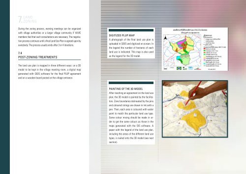
Digitized PLUP map<br />
A photograph of the final land use plan is<br />
uploaded in QGIS and digitized on-screen. In<br />
the legend the number of hectares of each<br />
land use is indicated. This map is also used<br />
as the legend for the 3D model.<br />
The land use plan is mapped in three different ways: on a 3D<br />
model to be kept in the village meeting room, a digital map<br />
generated with QGIS software for the final PLUP agreement<br />
and on a wooden board posted at the village entrance.<br />
Painting of the 3D model<br />
After reaching an agreement on the land use<br />
plan, the 3D model is painted by the facilitators.<br />
Zone boundaries delineated by the pins<br />
and coloured strings are drawn in ink with a<br />
pen. Then, each area is coloured with water<br />
paint to match the particular land use type.<br />
Some colour mixing should be made in order<br />
to get the same colours as those in the<br />
maps generated with the GIS software. A<br />
paper with the legend of the land use plan,<br />
including the areas of the different land use<br />
types, is nailed onto the 3D model (see next<br />
section).