Create successful ePaper yourself
Turn your PDF publications into a flip-book with our unique Google optimized e-Paper software.
7. QGIS<br />
for P3DM<br />
How to extract contour lines to build a 3D Model?<br />
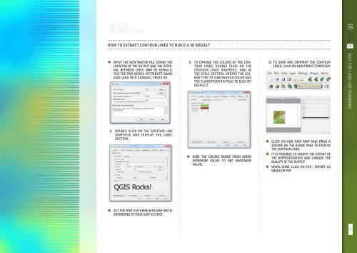
• Input the new raster file. Define the<br />
location of the output and the interval<br />
between lines (40m by default),<br />
tick the two boxes (attribute name<br />
and load into canvas); Press OK.<br />
9. To change the colors of the contour<br />
lines, double click on the<br />
contour lines shapefile, and in<br />
the Style section, update the legend<br />
type to continuous color and<br />
the classification field to ELEV (by<br />
default):<br />
10. To save and or/print the contour<br />
lines, click on New Print Composer:<br />
TOOLBOX 6 QGIS for land use planning<br />
8. Double click on the contour line<br />
shapefile and display the label<br />
section:<br />
• Here the colors range from green<br />
(minimum value) to red (maximum<br />
value).<br />
• Click on Add new map and drag a<br />
square on the blank page to display<br />
the contour lines.<br />
• It is possible to modify the extent of<br />
the representation and change the<br />
quality of the output.<br />
• When done, click on File / Export as<br />
Image or PDF.<br />
• Set the font size (here 50 in map units)<br />
according to your map extent.<br />
87


