
Create successful ePaper yourself
Turn your PDF publications into a flip-book with our unique Google optimized e-Paper software.
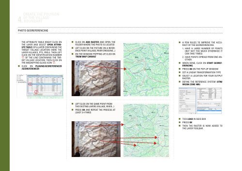
4.<br />
Create the polygon<br />
of the village<br />
boundary<br />
Photo georeferencing<br />
the attribute table (right click on<br />
the layer and select Open attribute<br />
table) of a layer containing the<br />
target village location (here the<br />
layer Villages_pts_proj). Then left<br />
click on the identification number<br />
of the line containing the target<br />
village location. Then click on<br />
the magnifying glass icon .<br />
• Click on Plugins/Georeferencer<br />
/Georeferencer<br />
• Click on Add Raster and open the<br />
folder where the photo is located<br />
• Left click on the picture on a reference<br />
point (village, river crossing...)<br />
• On the window popping-up, click on<br />
‘From map canvas’<br />
•A few rules to improve the accuracy<br />
of the georeferencing:<br />
1. Have a large number of points<br />
(but not too much otherwise it<br />
can take times)<br />
2. Have points spread from one another.<br />
•When done, click on Start georeferencing.<br />
•Press OK on the pop-up window<br />
•Set a linear transformation type<br />
•Select a location for your output<br />
raster.<br />
•Define the reference system (UTM/<br />
WGS84 Zone 48N)<br />
• Left click on the same point from<br />
the existing layers (village, river...)<br />
• Press OK and repeat the process at<br />
least 3-4 times<br />
•Tick Load in QGIS box<br />
•Press OK<br />
•Then the raster is now added to<br />
the layer toolbar.