- Page 1: 26 May 2011 City of Pawtucket Plann
- Page 4 and 5: TABLE OF CONTENTS INTRODUCTION VISI
- Page 6 and 7: P P P P P P EXECUTIVE SUMMARY Pawtu
- Page 8 and 9: TURNPIKE SYSTEM COMPONENTS and tree
- Page 11 and 12: INTRODUCTION EXISTING CONDITIONS Th
- Page 13 and 14: WEST AVE. PINE ST. ST. CT. ST. REET
- Page 15 and 16: Greenspace Sidewalks are the primar
- Page 17 and 18: Downtown does not have a traffic am
- Page 19: cars there all day. This disrupts t
- Page 23 and 24: INTRODUCTION CONCEPTS Rather than d
- Page 25 and 26: Historic Turnpike Routes Valley Fal
- Page 27 and 28: Segments of Turnpike Routes BROAD H
- Page 29 and 30: Views of existing and proposed Main
- Page 31 and 32: PROJECT 2 : TAKE THE EXCHANGE PDDP
- Page 33 and 34: Exchange Segments BROAD HIGH ROOSEV
- Page 35 and 36: Views of existing and proposed Exch
- Page 37 and 38: PROJECT 3 : “P”ARKING The above
- Page 39 and 40: MAIN Public parking lots to be sign
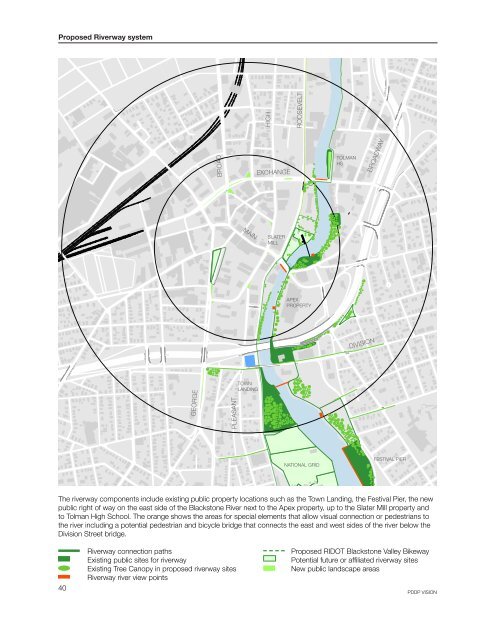
- Page 41: PROJECT 4 : ENJOY THE RIVERWAY The
- Page 45: CG PROJECT 5 USE DOWNTOWN GUIDANCE
- Page 48 and 49: VISION Defining Scope PREFERRED ALT
- Page 50 and 51: MAIN Exchange Street Scope Priority
- Page 53 and 54: DESIGN
- Page 55: MAIN Scope of the PDDP Projects BRO
- Page 58 and 59: DESIGN Traffic & Street Improvement
- Page 60 and 61: DESIGN Traffic & Street Improvement
- Page 62 and 63: DESIGN Traffic & Street Improvement
- Page 64 and 65: PROPOSED LOCATION OF BLACKSTONE VAL
- Page 66 and 67: DESIGN Traffic & Street Improvement
- Page 68 and 69: CONNECTION TO RE-ALIGNED PARK PLACE
- Page 70 and 71: DESIGN Traffic & Street Improvement
- Page 72 and 73: George Street and Park Place West a
- Page 74 and 75: DESIGN Traffic & Street Improvement
- Page 76 and 77: NEW TREES NEW PARKING 3” RAISED C
- Page 78 and 79: DESIGN Traffic & Street Improvement
- Page 80 and 81: TRAFFIC & STREET IMPROVEMENTS CONCL
- Page 82 and 83: DESIGN Public Parking Management PA
- Page 84 and 85: DESIGN Public Parking Management de
- Page 86 and 87: DESIGN Public Parking Management PA
- Page 88 and 89: Roosevelt Avenue Parking Lot RECOMM
- Page 90 and 91: Broad Street and Humes Street Parki
- Page 92 and 93:
PUBLIC PARKING MANAGEMENT CONCLUSIO
- Page 94 and 95:
DESIGN Bicycle & Transit Systems BI
- Page 96 and 97:
Bicycle parking types At each of th
- Page 98 and 99:
DESIGN Bicycle & Transit Systems TR
- Page 100 and 101:
TRANSIT SYSTEMS CONCLUSION Enhancin
- Page 102 and 103:
DESIGN Streetscape and Pedestrian S
- Page 104 and 105:
DESIGN Streetscape and Pedestrian S
- Page 106 and 107:
Existing lighting conditions EXCHAN
- Page 108 and 109:
DESIGN Streetscape and Pedestrian S
- Page 110 and 111:
DESIGN Streetscape and Pedestrian S
- Page 112 and 113:
Full replacement signs would be use
- Page 114 and 115:
DESIGN Streetscape and Pedestrian S
- Page 116 and 117:
Proposed sign type From the Highcha
- Page 118 and 119:
DESIGN Streetscape and Pedestrian S
- Page 120 and 121:
STREETSCAPE AND PEDESTRIAN SYSTEMS
- Page 122 and 123:
DESIGN Landscape LANDSCAPE PLAN GOA
- Page 124 and 125:
DESIGN Streetscape and Pedestrian S
- Page 126 and 127:
DESIGN Landscape TREE ORDINANCE GOA
- Page 128 and 129:
PROPOSED TREE LIST (PARTIAL) OUTSID
- Page 130 and 131:
DESIGN Landscape ECOLOGICAL GREEN S
- Page 132 and 133:
DESIGN Landscape RIVERWAY COMPONENT
- Page 134 and 135:
DESIGN Landscape BRIDGE PARK EAST G
- Page 136 and 137:
B Bridge Park East plan and section
- Page 138 and 139:
DESIGN Landscape PARK PLACE RE-ALIG
- Page 140 and 141:
LANDSCAPE CONCLUSION The PDDP team
- Page 142 and 143:
DESIGN Regulatory Framework The PDD
- Page 144 and 145:
Enhance design requirements The rev
- Page 147 and 148:
STATUS AND IMPLEMENTATION
- Page 149 and 150:
Responsible Agency Partner Agency F
- Page 151 and 152:
Responsible Agency Partner Agency F
- Page 153 and 154:
ADDITIONAL SERVICES The PDDP team w
- Page 155 and 156:
along with the potential of an East
- Page 157:
Opportunities The City of Pawtucket
- Page 160 and 161:
158
- Page 162 and 163:
160 PAWTUCKET DOWNTOWN DESIGN PLAN
- Page 164 and 165:
162 PAWTUCKET DOWNTOWN DESIGN PLAN
- Page 166 and 167:
164 PAWTUCKET DOWNTOWN DESIGN PLAN
- Page 168 and 169:
166 PAWTUCKET DOWNTOWN DESIGN PLAN
- Page 170 and 171:
168 PAWTUCKET DOWNTOWN DESIGN PLAN
- Page 172 and 173:
170 PAWTUCKET DOWNTOWN DESIGN PLAN
- Page 174 and 175:
172 PAWTUCKET DOWNTOWN DESIGN PLAN
- Page 176 and 177:
174 PAWTUCKET DOWNTOWN DESIGN PLAN
- Page 178 and 179:
176 PAWTUCKET DOWNTOWN DESIGN PLAN
- Page 180 and 181:
178 PAWTUCKET DOWNTOWN DESIGN PLAN
- Page 182 and 183:
180 PAWTUCKET DOWNTOWN DESIGN PLAN
- Page 184 and 185:
182 PAWTUCKET DOWNTOWN DESIGN PLAN
- Page 186 and 187:
184 PAWTUCKET DOWNTOWN DESIGN PLAN
- Page 188 and 189:
186
- Page 190 and 191:
188 PAWTUCKET DOWNTOWN DESIGN PLAN
- Page 192 and 193:
190 PAWTUCKET DOWNTOWN DESIGN PLAN
- Page 194 and 195:
192 PAWTUCKET DOWNTOWN DESIGN PLAN
- Page 196 and 197:
194 PAWTUCKET DOWNTOWN DESIGN PLAN
- Page 198 and 199:
196 PAWTUCKET DOWNTOWN DESIGN PLAN
- Page 200 and 201:
198 PAWTUCKET DOWNTOWN DESIGN PLAN
- Page 202 and 203:
200 PAWTUCKET DOWNTOWN DESIGN PLAN
- Page 204 and 205:
202 PAWTUCKET DOWNTOWN DESIGN PLAN
- Page 206 and 207:
204 PAWTUCKET DOWNTOWN DESIGN PLAN
- Page 208 and 209:
206 PAWTUCKET DOWNTOWN DESIGN PLAN
- Page 210 and 211:
208 PAWTUCKET DOWNTOWN DESIGN PLAN
- Page 212 and 213:
210 PAWTUCKET DOWNTOWN DESIGN PLAN
- Page 214 and 215:
212 PAWTUCKET DOWNTOWN DESIGN PLAN
- Page 216 and 217:
214 PAWTUCKET DOWNTOWN DESIGN PLAN
- Page 218 and 219:
216 PAWTUCKET DOWNTOWN DESIGN PLAN
- Page 220 and 221:
218 PAWTUCKET DOWNTOWN DESIGN PLAN
- Page 222 and 223:
220 PAWTUCKET DOWNTOWN DESIGN PLAN
- Page 224 and 225:
222 PAWTUCKET DOWNTOWN DESIGN PLAN
- Page 226 and 227:
224 PAWTUCKET DOWNTOWN DESIGN PLAN
- Page 228 and 229:
226 PAWTUCKET DOWNTOWN DESIGN PLAN
- Page 230 and 231:
228
- Page 232 and 233:
PARKING BUILDING STREET SECONDARY E
- Page 234 and 235:
ARTICULATE CHANGES IN FLOORS OR OTH
- Page 236 and 237:
These windows illustrate potential
- Page 238 and 239:
SIGN SIGN UNDESIRABLE The poor plac
- Page 240 and 241:
238 PAWTUCKET DOWNTOWN DESIGN PLAN
- Page 242 and 243:
240 PAWTUCKET DOWNTOWN DESIGN PLAN
- Page 244 and 245:
242 PAWTUCKET DOWNTOWN DESIGN PLAN
- Page 246 and 247:
244 PAWTUCKET DOWNTOWN DESIGN PLAN
- Page 248 and 249:
246 PAWTUCKET DOWNTOWN DESIGN PLAN
- Page 250 and 251:
248 PAWTUCKET DOWNTOWN DESIGN PLAN
- Page 252 and 253:
250 PAWTUCKET DOWNTOWN DESIGN PLAN
- Page 254 and 255:
252 PAWTUCKET DOWNTOWN DESIGN PLAN
- Page 256 and 257:
254 PAWTUCKET DOWNTOWN DESIGN PLAN
- Page 258 and 259:
256 PAWTUCKET DOWNTOWN DESIGN PLAN
- Page 260 and 261:
258 PAWTUCKET DOWNTOWN DESIGN PLAN
- Page 262 and 263:
260
- Page 264 and 265:
MAIN STREET ESTIMATE COMBINED ESTIM
- Page 266 and 267:
EXCHANGE STREET ESTIMATE COMBINED E
- Page 268 and 269:
EAST AVENUE EXTENSION - LONG-TERM C
- Page 270 and 271:
CURB TO CURB 268 PAWTUCKET DOWNTOWN
- Page 272 and 273:
EAST AVENUE EXTENSION - SHORT-TERM
- Page 274:
CURB TO CURB ONLY 272 PAWTUCKET DOW