2006 Parks, Trails and Open Space Plan - City of Lakeville
2006 Parks, Trails and Open Space Plan - City of Lakeville
2006 Parks, Trails and Open Space Plan - City of Lakeville

Create successful ePaper yourself
Turn your PDF publications into a flip-book with our unique Google optimized e-Paper software.
The staged MUSA expansions are proposed to build on existing development patterns,<br />
in-place sanitary sewer <strong>and</strong> roadway infrastructure. The sequencing <strong>of</strong> the MUSA<br />
staging is intended to postpone costly investments in new utility infrastructure until full<br />
utilization <strong>of</strong> the existing utilities is achieved.<br />
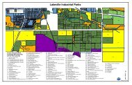
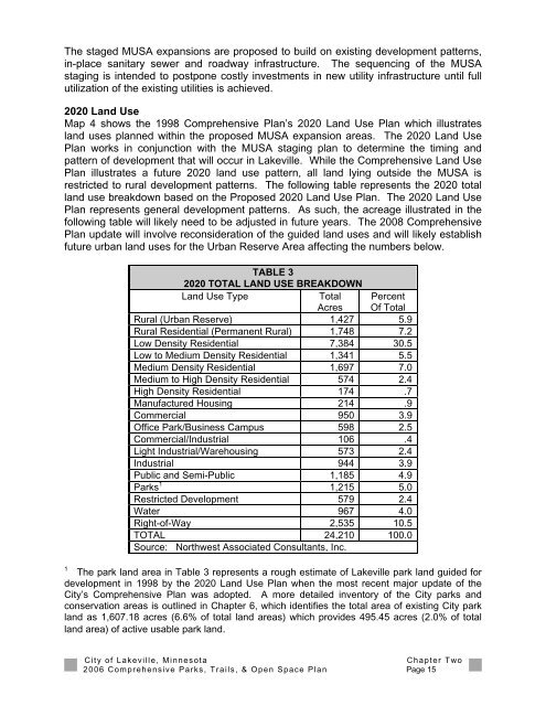
2020 L<strong>and</strong> Use<br />
Map 4 shows the 1998 Comprehensive <strong>Plan</strong>’s 2020 L<strong>and</strong> Use <strong>Plan</strong> which illustrates<br />
l<strong>and</strong> uses planned within the proposed MUSA expansion areas. The 2020 L<strong>and</strong> Use<br />
<strong>Plan</strong> works in conjunction with the MUSA staging plan to determine the timing <strong>and</strong><br />
pattern <strong>of</strong> development that will occur in <strong>Lakeville</strong>. While the Comprehensive L<strong>and</strong> Use<br />
<strong>Plan</strong> illustrates a future 2020 l<strong>and</strong> use pattern, all l<strong>and</strong> lying outside the MUSA is<br />
restricted to rural development patterns. The following table represents the 2020 total<br />
l<strong>and</strong> use breakdown based on the Proposed 2020 L<strong>and</strong> Use <strong>Plan</strong>. The 2020 L<strong>and</strong> Use<br />
<strong>Plan</strong> represents general development patterns. As such, the acreage illustrated in the<br />
following table will likely need to be adjusted in future years. The 2008 Comprehensive<br />
<strong>Plan</strong> update will involve reconsideration <strong>of</strong> the guided l<strong>and</strong> uses <strong>and</strong> will likely establish<br />
future urban l<strong>and</strong> uses for the Urban Reserve Area affecting the numbers below.<br />
TABLE 3<br />
2020 TOTAL LAND USE BREAKDOWN<br />
L<strong>and</strong> Use Type<br />
Total<br />
Acres<br />
Percent<br />
Of Total<br />
Rural (Urban Reserve) 1,427 5.9<br />
Rural Residential (Permanent Rural) 1,748 7.2<br />
Low Density Residential 7,384 30.5<br />
Low to Medium Density Residential 1,341 5.5<br />
Medium Density Residential 1,697 7.0<br />
Medium to High Density Residential 574 2.4<br />
High Density Residential 174 .7<br />
Manufactured Housing 214 .9<br />
Commercial 950 3.9<br />
Office Park/Business Campus 598 2.5<br />
Commercial/Industrial 106 .4<br />
Light Industrial/Warehousing 573 2.4<br />
Industrial 944 3.9<br />
Public <strong>and</strong> Semi-Public 1,185 4.9<br />
<strong>Parks</strong> 1 1,215 5.0<br />
Restricted Development 579 2.4<br />
Water 967 4.0<br />
Right-<strong>of</strong>-Way 2,535 10.5<br />
TOTAL 24,210 100.0<br />
Source: Northwest Associated Consultants, Inc.<br />
1<br />
The park l<strong>and</strong> area in Table 3 represents a rough estimate <strong>of</strong> <strong>Lakeville</strong> park l<strong>and</strong> guided for<br />
development in 1998 by the 2020 L<strong>and</strong> Use <strong>Plan</strong> when the most recent major update <strong>of</strong> the<br />
<strong>City</strong>’s Comprehensive <strong>Plan</strong> was adopted. A more detailed inventory <strong>of</strong> the <strong>City</strong> parks <strong>and</strong><br />
conservation areas is outlined in Chapter 6, which identifies the total area <strong>of</strong> existing <strong>City</strong> park<br />
l<strong>and</strong> as 1,607.18 acres (6.6% <strong>of</strong> total l<strong>and</strong> areas) which provides 495.45 acres (2.0% <strong>of</strong> total<br />
l<strong>and</strong> area) <strong>of</strong> active usable park l<strong>and</strong>.<br />
<strong>City</strong> <strong>of</strong> <strong>Lakeville</strong>, Minnesota<br />
Chapter Two<br />
<strong>2006</strong> Comprehensive <strong>Parks</strong>, <strong>Trails</strong>, & <strong>Open</strong> <strong>Space</strong> <strong>Plan</strong> Page 15