2006 Parks, Trails and Open Space Plan - City of Lakeville
2006 Parks, Trails and Open Space Plan - City of Lakeville
2006 Parks, Trails and Open Space Plan - City of Lakeville

Create successful ePaper yourself
Turn your PDF publications into a flip-book with our unique Google optimized e-Paper software.
Vision <strong>of</strong> the <strong>Parks</strong>, <strong>Trails</strong> <strong>and</strong> <strong>Open</strong> <strong>Space</strong> System<br />
The vision for <strong>Lakeville</strong>’s <strong>Parks</strong>, <strong>Trails</strong> <strong>and</strong> <strong>Open</strong> <strong>Space</strong> <strong>Plan</strong> began with the first parks<br />
<strong>and</strong> open space study in 1970. Through the <strong>City</strong>’s foresight, dedication to planning <strong>and</strong><br />
commitment to park l<strong>and</strong> development <strong>and</strong> environmental protection, the <strong>City</strong> has been<br />
successful in establishing a superior municipal park <strong>and</strong> trail system. A 2005<br />
community survey identifies that over 90 percent <strong>of</strong> those surveyed believe the<br />
elements <strong>of</strong> the park system to be “excellent” or “good”.<br />
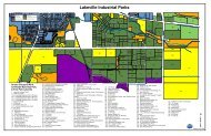
The following map provides a vision <strong>of</strong> the <strong>City</strong>’s 2020 park, trails <strong>and</strong> open space plan.<br />
This graphic plan, in conjunction with the policy plan, system recommendations, <strong>and</strong> the<br />
individual park recommendations to be developed as an appendix <strong>of</strong> the <strong>Parks</strong>, <strong>Trails</strong><br />
<strong>and</strong> <strong>Open</strong> <strong>Space</strong> <strong>Plan</strong> are intended to establish the framework for decision-making on<br />
future system improvements. The following table provides estimates <strong>of</strong> future park l<strong>and</strong><br />
needed to implement the long range park system. These acreage estimates below<br />
correspond to the acreage figures included with search areas identified on the planning<br />
district maps in previous sections <strong>of</strong> this Chapter.<br />
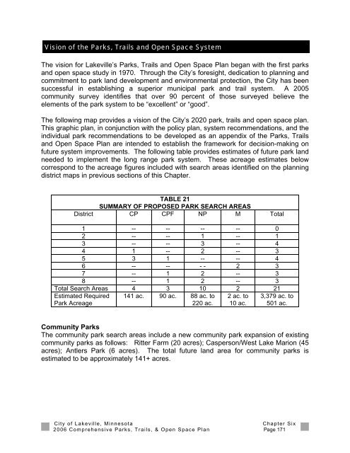
TABLE 21<br />
SUMMARY OF PROPOSED PARK SEARCH AREAS<br />
District CP CPF NP M Total<br />
1 -- -- -- -- 0<br />
2 -- -- 1 -- 1<br />
3 -- -- 3 -- 4<br />
4 1 -- 2 -- 3<br />
5 3 1 -- -- 4<br />
6 -- -- - - 2 3<br />
7 -- 1 2 -- 3<br />
8 -- 1 2 -- 3<br />
Total Search Areas 4 3 10 2 21<br />
Estimated Required<br />
Park Acreage<br />
141 ac. 90 ac. 88 ac. to<br />
220 ac.<br />
2 ac. to<br />
10 ac.<br />
3,379 ac. to<br />
501 ac.<br />
Community <strong>Parks</strong><br />
The community park search areas include a new community park expansion <strong>of</strong> existing<br />
community parks as follows: Ritter Farm (20 acres); Casperson/West Lake Marion (45<br />
acres); Antlers Park (6 acres). The total future l<strong>and</strong> area for community parks is<br />
estimated to be approximately 141+ acres.<br />
<strong>City</strong> <strong>of</strong> <strong>Lakeville</strong>, Minnesota<br />
Chapter Six<br />
<strong>2006</strong> Comprehensive <strong>Parks</strong>, <strong>Trails</strong>, & <strong>Open</strong> <strong>Space</strong> <strong>Plan</strong> Page 171