The Padiham Heritage Appraisal - Burnley Borough Council
The Padiham Heritage Appraisal - Burnley Borough Council
The Padiham Heritage Appraisal - Burnley Borough Council
- No tags were found...

You also want an ePaper? Increase the reach of your titles
YUMPU automatically turns print PDFs into web optimized ePapers that Google loves.
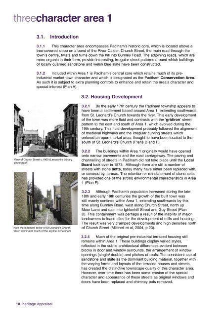
threecharacter area 13.1. Introduction3.1.1 This character area encompasses <strong>Padiham</strong>’s historic core, which is located above atree-covered slope on a bend of the River Calder. Church Street, the main road through thetown’s centre, twists and turns down the hill into <strong>Burnley</strong> Road. <strong>The</strong> adjoining roads, which aremore organic in their form, provide interesting, irregular street patterns around which buildingsof locally quarried sandstone and welsh blue slate have been constructed.3.1.2 Included within Area 1 is <strong>Padiham</strong>’s central core which retains much of its preindustrialmarket town character and which is designated as the <strong>Padiham</strong> Conservation Area.As such it is subject to extra planning controls to enhance and retain the area’s character andspecial interest (Plan A).3.2. Housing Development3.2.1 By the early 17th century the <strong>Padiham</strong> township appears tohave been a settlement based around Area 1, extending southwardsfrom St. Leonard’s Church towards the river. This early developmentof the town was more fluid and contrasts with the ‘gridiron’ streetpattern to the east and south of Area 1, which evolved during the19th century. This fluid development probably followed the alignmentof medieval highways and the irregular curving streets whichentered an open market area, thought to have been located to thesouth of St. Leonard’s Church (Plans B and F).View of Church Street c.1900 (Lancashire Libraryphotograph)Note the landmark tower of St Leonard’s Church,which dominates much of the skyline in <strong>Padiham</strong>3.2.2 <strong>The</strong> buildings within Area 1 originally would have openedonto narrow pavements and the road carriageway. <strong>The</strong> paving andchannelling of streets in <strong>Padiham</strong> did not take place until the LocalBoard took over in 1873. Although there are still a number ofstreets with stone setts, today many have either been replaced with,or covered by, tarmac. <strong>The</strong> retention or reinstatement of stone settshas provided one of the strong environmental characteristics in Area1 (Plan F).3.2.3 Although <strong>Padiham</strong>’s population increased during the late18th and early 19th centuries the growth of the built town wasstill mainly confined within Area 1, extending southwards by thistime along <strong>Burnley</strong> Road, west along Church Street, north upMoor Lane and east into Ightenhill Street and Guy Street (PlanB). This containment was perhaps a result of the inability of majorlandowners to lease sites for the development of mills and housing.<strong>The</strong> result was very cramped developments and high densities northof Church Street (Mitchell et al, 2004, p.23).3.2.4 Much of the original pre-industrial terraced housing stillremains within Area 1. <strong>The</strong>se buildings display varied styles,reflected in the subtle architectural differences evident betweenblocks in door and window surrounds, the arrangement of windowopenings (single/ double) and pitches of roofs. <strong>The</strong> consistent use ofsandstone and slate as the dominant building material, together withthe varying forms and layouts of the terraced houses and streets,has created the distinctive townscape quality of this character area.However, over time there has been some erosion of the specialcharacter and appearance of these streets as original windows anddoors have been replaced and chimney pots removed.10 heritage appraisal