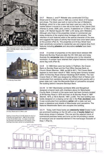
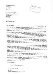
This photograph shows John Paul Webster’s butcher’sshop in <strong>Burnley</strong> Road c.1880 (Lancashire Libraryphotograph).1-13 <strong>Burnley</strong> Road 20063.4.7 Messrs J. and P. Webster also constructed 2-8 GuyStreet and 6-12 Moor Lane in 1885 as a corner block of 8 housesand shops. <strong>The</strong> block was built on land at the rear of Webster’sBuildings, which for a few years had been used as a site for themarket before it moved to a new site at the back of the Liberal Club(Haines & Jones, 2006, pers. comm). A datestone on 12 Moor Lanereads ‘J.W. Market Square AD 1885’ (J.W. being John Webster).Although only three of the properties remain in commercial usetoday evidence of the original shop frontages still remains. <strong>The</strong>retention of such features adds to the special character of the areaand suggests the types of activity that would have once taken placeat this junction (Plan A). <strong>The</strong> properties at 2-8 Guy Street havebeen sensitively converted to residential use and original shop frontfeatures including pilasters and decorative corbels have beenretained.3.4.8 A number of properties on the island block between MillStreet and <strong>Burnley</strong> Road pre-date the OS 1844 plan and todayillustrate the vernacular style of buildings prior to the industrialrevolution. A number have retained their original features includingstone flag roofs (Plan B).3.4.9 In 1868 there were two banks in <strong>Padiham</strong>, the CravenBank on <strong>Burnley</strong> Road and the Post Office Savings Bank onChurch Street (Mannex, 1868, pp.820 & 821). <strong>The</strong> Craven Bankappears to have been rebuilt in 1893, having been formerly locatedwithin 4-8 <strong>Burnley</strong> Road (Hanson Buildings BCR 54230). <strong>The</strong> newCraven Bank of 1893 was designed by William Dent of Nelson andconstructed from sandstone ashlar and polished pink granite with agreen slate roof. Later the Mercantile Bank of Lancashire occupiedthe building before it became Barclays Bank.3.4.10 In 1901 Manchester architects Mills and Murgatroyddesigned a branch bank with chambers above for ManchesterCounty Bank. A branch of the same bank had been formerly locatedat 69 <strong>Burnley</strong> Road in 1879 and then at 45 <strong>Burnley</strong> Road in 1887(Barrett, 1879, p.183 & Barrett, 1887, p.239). <strong>The</strong> new building wasboldly designed on a sloping corner site in the Free Jacobean style.It was constructed from sandstone ashlar with a slate roof andbears a datestone and shields of Manchester and Lancashire. <strong>The</strong>National Westminster Bank now occupies this building.2-8 Guy Street and 6-12 Moor LaneBuilding Control Record 54196 details the block of8 houses and shops built c. 1885 on the junctionof Guy St and Moor Lane. It is easy to see fromthis elevation that alterations to the exterior of thebuildings have been carried out sympathetically.3.4.11 Today, both these banks are statutorily listed Grade II andare prominent buildings on the hill with a row of locally listed two/three storey shops in between. This row and the adjacent block ofcommercial premises twists and turns up the hill providing a senseof enclosure and an essential element in the townscape character ofArea 1 (Plan A).18 heritage appraisal
Today the locally listed Hanson Buildings are a good example of sensitiverestoration and refurbishment of a Victorian property. This has been achievedin part through the repair and reinstatement of original shop front features andsash windows. A single commercial company now occupies the ground floorwhilst the upper two storeys have been converted into flats (Plan A).This photograph illustrates the poor condition of Hanson Buildings (4-8 <strong>Burnley</strong> Road) in 1987 prior to refurbishment. <strong>The</strong> Craven Bank isthought to have been located within 8 <strong>Burnley</strong> Road by at least 1868(Mannex, 1868, p. 821) (Lancashire Library photograph).This view is of the block of shops on the hill with boththe top and bottom banksInappropriate shop fronts have replaced many of the original ones onthe hill, <strong>Burnley</strong> Road. Although pilasters and corbels are still evidentchanges to the fascia boards, new windows and roller shutters arehaving a negative effect on the character and appearance of the area(Plan F).3.4.12 <strong>The</strong> commercial properties on the <strong>Burnley</strong> Road hill have undergone a number ofchanges over time, many having originally been built as shops with living accommodationabove. Although a number of properties have retained original architectural features such aspilasters and detailed corbels, the use of inappropriate, often oversized fascia boards, usedto either cover or replace these features, has detracted from the quality and character of theblock. <strong>The</strong>refore a scheme to reinstate lost architectural features should be supported (Plan F).3.5. Public Houses And Inns3.5.1 In 1830 the Beer Act abolished excise duty on beer and all that was required toestablish a beerhouse, or to sell beer was a two guinea licence from the local excise office.‘<strong>The</strong> result was large increases in the number of beerhouses, particularly in the poor areas oftowns, where people went to escape temporarily from the squalor of their surroundings’ (Glenn& WEA, 1986).3.5.2 <strong>Padiham</strong> was no exception with a large concentration of inns and beerhouses locatedwithin Area 1 and clustered around the original market place. <strong>The</strong> growth in the number ofdrinking establishments in <strong>Padiham</strong> has been documented in the commercial directories of the19th century. For example, prior to the Beer Act the Lancashire General Directory of 1818-1820 (p 123-4) detailed six inns in <strong>Padiham</strong>. <strong>The</strong>se were the (Old) Black Bull, Bay Horse,Swan, Weavers Arms, Masons Arms and Starkie Arms. By 1834 there were 10 taverns/publichouses and 10 retailers of beer serving a population of 3,529 (Pigot, 1834, p.507).3.5.3 However, the beerhouses were a source of complaint from churches and leading tradespersonsand by 1869 the control of licences was transferred to the local magistrates. ‘Many beerhouseswere closed after the licence transfer, not for those reasons, but because of their unsuitableaccommodation and inadequate sanitary arrangements’ (Glenn & WEA, 1986). By 1879 there were14 hotels/inns and 17 beerhouses listed, serving an estimated population of 6917 (Barrett, 1879,pp.170, 183 & 186). This equated to approximately one drinking establishment for every 223 people.heritage appraisal 19
- Page 2 and 3: ‘Heritage is all around us. We li
- Page 4: oneintroduction1.1 Housing Market R
- Page 12 and 13: threecharacter area 13.1. Introduct
- Page 14 and 15: 3.2.9 On Whalley Road Epworth House
- Page 16 and 17: 3.2.19 Much of the cleared land in
- Page 18 and 19: Victoria Mill, Ightenhill Street.3.
- Page 22 and 23: 3.5.4 Four of the oldest surviving
- Page 24 and 25: This Lancashire Library photograph
- Page 26 and 27: 3.6 Clubs and Community BuildingsFo
- Page 28 and 29: Former Wesley Chapel in West Street
- Page 30 and 31: 3.8.4 In 1814 ‘The British and Fo
- Page 32 and 33: 3.10. Landmarks, views, green space
- Page 34 and 35: fourcharacter area 24.1 introductio
- Page 36 and 37: Rendered property in the Garden Str
- Page 38 and 39: Fairweather Court/Town Hill BankFai
- Page 40 and 41: oneintroduction38 heritage appraisa
- Page 42 and 43: fivecharacter area 35.1 Introductio
- Page 44 and 45: Industrial Buildings5.3.8 The ‘Go
- Page 46 and 47: Alma MillToday British Velvets occu
- Page 48 and 49: 5.4. Housing5.4.1 Victorian neighbo
- Page 50 and 51: 7-23 Grove Lane. 21 Grove Lane appe
- Page 52 and 53: Number 46 Ingham Street was origina
- Page 54 and 55: sixcharacter area 46.1. Introductio
- Page 56 and 57: 6.2.7 Though disused, the line stil
- Page 58 and 59: 6.3. Housing6.3.1 Development began
- Page 60 and 61: Early residential area 1860-18906.3
- Page 62 and 63: Former shops within the wider stree
- Page 64 and 65: Architectural features and detailin
- Page 66 and 67: Looking up Burnley Road from the Br
- Page 68 and 69: 66 heritage appraisalCross Bank Day
- Page 70 and 71:
6.6. Landmarks, views, greenspaces
- Page 72 and 73:
sevencharacter area 57.1 Introducti
- Page 74 and 75:
7.3.6 Numbers 21-43 Green Lane, kno
- Page 76 and 77:
7.4 Late 20th century housing7.4.1
- Page 78:
Levant Mill7.5.7 Butterworth and Br
- Page 82 and 83:
Stockbridge Road: Barrett’s Direc
- Page 84 and 85:
7.9 Landmarks, views, green spaces
- Page 86 and 87:
eightcharacter area 68.1. Introduct
- Page 88 and 89:
Wakes Week, 1920s - a large crowd s
- Page 90 and 91:
8.2.12 In terms of its architecture
- Page 92 and 93:
1870s: Railway Road8.4.3 Building r
- Page 94 and 95:
1880s Whittaker Street8.4.9 Develop
- Page 96 and 97:
Post Office8.5.3 The Post Office, c
- Page 98 and 99:
ninecharacter area 79.1 introductio
- Page 100 and 101:
9.5 Landmarks, views, green spaces
- Page 102 and 103:
tenheritage and future regeneration
- Page 104 and 105:
appendixa-protected featuresA range
- Page 106 and 107:
appendixb-sourcesUnlike Burnley and
- Page 108 and 109:
Building Control RecordsBurnley Bor
- Page 110 and 111:
Handloom weaver Independent artisan
- Page 112:
Designed by Graphics, Burnley Counc