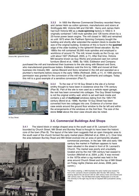
Victoria Mill, Ightenhill Street.3.3.3 In 1855 the Mannex Commercial Directory recorded Henryand James Helm as cotton spinners, manufacturers and sizers atSmithygate Mill, Victoria Mill and Old Mill. Henry and James Helmhad built Victoria Mill as a mule-spinning factory in 1852-3. Itoriginally contained 7,400 mule spindles and 126 looms driven by a25-horse power beam engine. <strong>The</strong> mill closed in 1863 and remainedso until 1873 when the <strong>Padiham</strong> Spinning Company bought thebuilding and shortly after extended the western block to double thesize of the original building. Evidence of this is found in the quoinededge of the older building in the Ightenhill Street elevation. By the1880s the mill contained 30,000 mule spindles and employed aworkforce of around 75. <strong>The</strong> mill, known locally as the Co-op, ranuntil about 1927 (Rothwell, 2005, p.11). After that time, VictoriaMill became known as Guy Works and produced cast iron schoolfurniture (Bond et al, 1998). By 1930, Eddleston and Companypurchased the mill and transferred their business to the site along with Blezard and Sons,who manufactured greenhouse boilers. Eddleston sold the firm by 1989 and moved all theirbusiness into Industry Mill. James Blezard and Sons remained in the mill and operated as aplumber’s merchants before closure in the early 1990s (Rothwell, 2005, p.11). In 1995 planningpermission was granted for the conversion of the mill into 25 apartments and cottages. Todaythis mill is a good example of a sensitive conversion (Plan F).3.3.4 To the rear of 10-18 Guy Street is the site of a formersmithy thought to have been in existence since the 17th century(Plan B). Part of the site is now used as a vehicle repair garage,the rest has been converted into cottages. <strong>The</strong> Guy Street frontageis not the original smithy wall, which is set well back inside andcontains a set of mullioned windows dating from the 16th/17thcentury (Bond et al, 1998). Number 10 Guy Street has beenconverted from two cottages into one. Evidence of a former doorcase exists around the ground floor window to the far left and withinthe arrangements of the windows on the first floor. <strong>The</strong> size of thestone lintel above the door case should also be noted.10 Guy Street3.4. Commercial Buildings And Shops3.4.1 <strong>The</strong> island block or wedge shaped area to the south east of St. Leonard’s Churchbounded by Church Street, Mill Street and <strong>Burnley</strong> Road is thought to have been the historiccore of the town (Plan B). <strong>The</strong> layout of the later town suggests that an open triangular area tothe south east of the church formed the early market place (Mitchell et al, 2004, p.1). Over timethe area between <strong>Burnley</strong> Road and Mill Street evolved into an area of permanently situatedcommercial premises. In the late 18th and early 19thcentury the market in <strong>Padiham</strong> appears to havebeen situated in the street in front of St. Leonard’sChurch. <strong>The</strong> market was poorly and unsuitablylocated and by the mid 19th century had ceased tofunction (Mitchell et al, 2004, p.26). It was revivedin the 1870s when a rag market was held in thearea around Church Street and the top of Mill Streeton Friday nights (Haines and Jones, 2006, pers.comm.).This artist’s drawing, c.1850 illustrates the early market area located infront of St. Leonard’s Church sometime after the late 18th century. <strong>The</strong>drawing depicts the old church with its 16th century tower and chancel and18th century nave. <strong>The</strong> Old Black Bull (Cellar Restaurant) is to the left.<strong>The</strong> chimney to the right may be that of Claybank Mill (Lancashire Libraryimage).16 heritage appraisal
3.4.2 <strong>The</strong> <strong>Padiham</strong> Urban District <strong>Council</strong> (PUDC) was responsible for the administration of<strong>Padiham</strong> Market. In 1894 a new open market area, which held a weekly market, was establishedin an area north of Sowerby Street/rear of the old Liberal Club in <strong>Burnley</strong> Road, not far from thesite of the present day market (Haines & Jones, 1994, p.24). In 1913, a market hall was included inthe plans for the new municipal buildings, which were proposed for the site of the old gas works onStation Road. However, when the gas works were demolished, the market was moved to the otherside of Station Road. It was a wooden building constructed partially on the site of the present firestation and was opened in January 1914. It originally comprised 42 stalls, but expanded over the next20 years to 80 stalls. Wartime shortages and rationing may have been responsible for the market’sdecline and eventual closure in 1956 (Haines & Jones, 1994, p.24). <strong>The</strong> present day open marketreopened again in 1984 and occupies the site of the former coal staithe to the rear of <strong>Burnley</strong> Road.Large wooden gateposts (Plan A) are the last remaining evidence of the coal staithe where coal from<strong>Padiham</strong> pits was brought by ginny wagons. Today the market has a number of brightly colouredpermanent stalls which occupy the site (Plan B & C).3.4.3 Throughout the early to mid 19th century Church Street remained the main shoppingarea, but towards the end of the century the focus for shopping shifted eastwards to <strong>Burnley</strong>Road (Mitchell et al, 2004, p.26). From 1881 the terminus for trams from <strong>Burnley</strong> was situatedat the bottom of the hill in <strong>Burnley</strong> Road, which may also have contributed to the shift of thecommercial centre of the town. Although most commercial premises would have been built assuch, a number of dwellings were converted into shops and businesses over time. <strong>The</strong>re arestill a number of shops situated along Church Street today, many retaining features from theiroriginal shop frontages, whilst others have been unsympathetically altered (Plan F).3.4.4 Block 3-13 Church Street was built in several stages during the 19th century and liesopposite St. Leonard’s Church. Numbers 3-11 are locally listedand appear to have been built prior to 1850 (Plans A & B & C).Large quoined detailing on the north elevation of 3 Church Streetsuggests that this property was once a separate building. Charlesand Joseph Wilkinson were known to have operated a butcher’sshop from this property by at least 1872 (Worrell, 1872, p.190).Evidence of its former use exists in the line of small iron bracketsleft on Calder Street, which were used to support a meat flight fromthe slaughterhouse to the shop (Bond et al, 1998). All properties onthe block are currently in use with shops and a restaurant at groundfloor and living accommodation above.3.4.5 One of the principal 19th century commercial buildings inArea 1 was the Oddfellows Hall. This building was constructed in1845 and has three storeys of sandstone ashlar with a slate roofand copings. <strong>The</strong> Moriah Lodge of the Order of Oddfellows onceused the first floor whilst shops, the Oddfellows Arms, flats and evena private club (1980s) have occupied others over time. <strong>The</strong> Hall is astatutorily listed Grade II building (Plan A).3.4.6 In 1878 Messrs J. and P. Webster constructed a block ofpurpose built shops with accommodation above on the junction of<strong>Burnley</strong> Road and Moor Lane (1-13 <strong>Burnley</strong> Road) (Plan A). This wasbuilt directly behind the butcher’s shop (old No 1 <strong>Burnley</strong> Road), whichwas once run by John Paul Webster until he moved his business into thenew block. <strong>The</strong> same family continued to run this business until CharlieWebster retired in the late 20th century. <strong>The</strong> terrace has attractive anddetailed mouldings around the triple arched windows to the first floors.A number of the shops in this block now appear to be vacant and othershave had unsympathetic changes made to the shop frontages. Someproperties have retained some original features. <strong>The</strong> block would benefitfrom the reinstatement of traditional architectural features to the <strong>Burnley</strong>Road frontage (Plan F).3-13 Church Street2 Bank Streeet and 4-6 North Street, knownas the Oddfellows Hall, is currently undergoingrefurbishment. On the North Street elevation of thebuilding a plaque reads ERECTED BY THE I.O. OFO.F.M.L. A.D. 1845.heritage appraisal 17
- Page 2 and 3: ‘Heritage is all around us. We li
- Page 4: oneintroduction1.1 Housing Market R
- Page 12 and 13: threecharacter area 13.1. Introduct
- Page 14 and 15: 3.2.9 On Whalley Road Epworth House
- Page 16 and 17: 3.2.19 Much of the cleared land in
- Page 20 and 21: This photograph shows John Paul Web
- Page 22 and 23: 3.5.4 Four of the oldest surviving
- Page 24 and 25: This Lancashire Library photograph
- Page 26 and 27: 3.6 Clubs and Community BuildingsFo
- Page 28 and 29: Former Wesley Chapel in West Street
- Page 30 and 31: 3.8.4 In 1814 ‘The British and Fo
- Page 32 and 33: 3.10. Landmarks, views, green space
- Page 34 and 35: fourcharacter area 24.1 introductio
- Page 36 and 37: Rendered property in the Garden Str
- Page 38 and 39: Fairweather Court/Town Hill BankFai
- Page 40 and 41: oneintroduction38 heritage appraisa
- Page 42 and 43: fivecharacter area 35.1 Introductio
- Page 44 and 45: Industrial Buildings5.3.8 The ‘Go
- Page 46 and 47: Alma MillToday British Velvets occu
- Page 48 and 49: 5.4. Housing5.4.1 Victorian neighbo
- Page 50 and 51: 7-23 Grove Lane. 21 Grove Lane appe
- Page 52 and 53: Number 46 Ingham Street was origina
- Page 54 and 55: sixcharacter area 46.1. Introductio
- Page 56 and 57: 6.2.7 Though disused, the line stil
- Page 58 and 59: 6.3. Housing6.3.1 Development began
- Page 60 and 61: Early residential area 1860-18906.3
- Page 62 and 63: Former shops within the wider stree
- Page 64 and 65: Architectural features and detailin
- Page 66 and 67: Looking up Burnley Road from the Br
- Page 68 and 69:
66 heritage appraisalCross Bank Day
- Page 70 and 71:
6.6. Landmarks, views, greenspaces
- Page 72 and 73:
sevencharacter area 57.1 Introducti
- Page 74 and 75:
7.3.6 Numbers 21-43 Green Lane, kno
- Page 76 and 77:
7.4 Late 20th century housing7.4.1
- Page 78:
Levant Mill7.5.7 Butterworth and Br
- Page 82 and 83:
Stockbridge Road: Barrett’s Direc
- Page 84 and 85:
7.9 Landmarks, views, green spaces
- Page 86 and 87:
eightcharacter area 68.1. Introduct
- Page 88 and 89:
Wakes Week, 1920s - a large crowd s
- Page 90 and 91:
8.2.12 In terms of its architecture
- Page 92 and 93:
1870s: Railway Road8.4.3 Building r
- Page 94 and 95:
1880s Whittaker Street8.4.9 Develop
- Page 96 and 97:
Post Office8.5.3 The Post Office, c
- Page 98 and 99:
ninecharacter area 79.1 introductio
- Page 100 and 101:
9.5 Landmarks, views, green spaces
- Page 102 and 103:
tenheritage and future regeneration
- Page 104 and 105:
appendixa-protected featuresA range
- Page 106 and 107:
appendixb-sourcesUnlike Burnley and
- Page 108 and 109:
Building Control RecordsBurnley Bor
- Page 110 and 111:
Handloom weaver Independent artisan
- Page 112:
Designed by Graphics, Burnley Counc