- Page 1:
Monorail Removal ProjectReview of E
- Page 4 and 5:
This report has been prepared by GH
- Page 6 and 7:
6. Community and stakeholder consul
- Page 8 and 9:
Table 8.2 Listed heritage items wit
- Page 11 and 12:
Glossary of termsTermArterial roadB
- Page 13 and 14:
Executive summaryOverviewThis revie
- Page 15 and 16:
landowner. The concrete and reinfor
- Page 17 and 18:
What were the key issues raised?Key
- Page 19 and 20:
approval under the Heritage Act, wo
- Page 21 and 22:
BeforePhotomontage 2 - View along P
- Page 23:
espond to community feedback in a s
- Page 27 and 28:
1. Introduction1.1 OverviewIn March
- Page 29 and 30:
1.3 Purpose of the REFFor an activi
- Page 31:
NORTHSYDNEYMilsonsPointPort Jackson
- Page 34 and 35: Station Location Ownership Position
- Page 36 and 37: 300PYRMONTHarboursideMurray StreetI
- Page 38 and 39: (3) Development for the purposes of
- Page 40 and 41: 3.4.2 Roads Act 1993Under section 1
- Page 42 and 43: Protected matterMatter located with
- Page 45: Part B The proposalGHD | Transport
- Page 48 and 49: As a result of these factors, the N
- Page 50 and 51: would be difficult to increase the
- Page 52 and 53: Further information on these work c
- Page 54 and 55: Figure 5.2 Concept for phase 1 of w
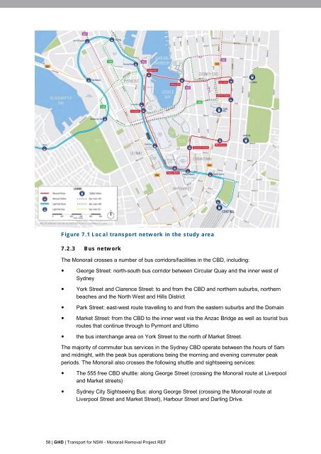
- Page 56 and 57: • Subject to finalising the detai
- Page 58 and 59: • Phase 3 - Removal work• Phase
- Page 60 and 61: • Phase 5 - Make good at street l
- Page 62 and 63: ParameterPhase 5 Make good at stree
- Page 64 and 65: • removal of contractor’s equip
- Page 66 and 67: Work phasePhase 3 - Removalworks ab
- Page 68 and 69: 5.8.2 Work hoursBackgroundThe ‘In
- Page 70 and 71: Work component/task Approximate dur
- Page 72 and 73: 6.2 Consultation during REF prepara
- Page 74 and 75: Meeting type Agencies Date ofmeetin
- Page 76 and 77: ActivityWebsiteLetter to government
- Page 79: Part C Environmental impact assessm
- Page 82 and 83: also supported by passenger surveys
- Page 86 and 87: Table 7.2 Cycle infrastructure in t
- Page 88 and 89: Maintenance Workshop. Traffic gener
- Page 90 and 91: arrive at the site before 10pm and
- Page 92 and 93: 7.3.10 Potential long term impactsT
- Page 94 and 95: - Detours associated with road clos
- Page 96 and 97: Table 8.1 Heritage items in the stu
- Page 98 and 99: Table 8.2 Listed heritage items wit
- Page 100 and 101: Map ref(figure8.1)Item name Address
- Page 102 and 103: minimise potential impacts on herit
- Page 104 and 105: • A detailed work method statemen
- Page 106 and 107: • Darling Park Station.Noise moni
- Page 108 and 109: As the work duration would be limit
- Page 110 and 111: ReceiverExternal noisecriteria (dBA
- Page 112 and 113: Table 9.6 Assessment of impacts of
- Page 114 and 115: Table 9.8 Heritage listed buildings
- Page 116 and 117: CriteriaL Aeq(15 min) noise level a
- Page 118 and 119: Table 10.1Urban character areasUrba
- Page 120 and 121: 10.2.2 Visual elements of the Monor
- Page 122 and 123: Darling Drive facing westDarling Dr
- Page 124 and 125: Table 10.2Long term visual impactsU
- Page 126 and 127: Existing viewPotential view followi
- Page 129 and 130: 11. Socio-economics and land use11.
- Page 131 and 132: Table 11.1Overview of land uses in
- Page 133 and 134: King StreetDarlingHarbourYork Stree
- Page 135 and 136:
There are approximately 20,000 busi
- Page 137 and 138:
Long term impactsThe main potential
- Page 139:
• Further consultation with relev
- Page 142 and 143:
• resource use and materials• p
- Page 144 and 145:
Relevant sustainability targets and
- Page 146 and 147:
Approach to management of wasteThe
- Page 148 and 149:
continuous improvement and innovati
- Page 150 and 151:
• Methods for management of emiss
- Page 152 and 153:
There is potential for lead paint t
- Page 154 and 155:
The works undertaken as part of the
- Page 157:
Part D ConclusionGHD | Transport fo
- Page 160 and 161:
selected to undertake work would be
- Page 162 and 163:
IDnumberMitigation measureSensitive
- Page 164 and 165:
IDnumberMitigation measurepre-start
- Page 166 and 167:
IDnumberMitigation measureM.1 The p
- Page 168 and 169:
• development of a detailed waste
- Page 171:
16. Reference listAustralian Bureau
- Page 175:
Appendix A Photographic inventoryGH
- Page 178 and 179:
Covered walkway from Convention Sta
- Page 180 and 181:
Galeries Victoria StationGaleries V
- Page 183 and 184:
Table B.1 Heritage items in the stu
- Page 185 and 186:
Map ref(figure8.1)Item name and add
- Page 187 and 188:
Map ref(figure8.1)Item name and add
- Page 189:
Appendix C Clause 228 and ecologica
- Page 192 and 193:
Clause 228 factor Summary of result
- Page 195 and 196:
GHD133 Castlereagh St Sydney NSW 20