- Page 2 and 3:
Table of ContentsList of Figures ..
- Page 4 and 5:
Chapter 8: Montgomery County ......
- Page 6 and 7:
4-1. Alabama county map highlightin
- Page 8 and 9:
6-7. Butler County detail of John L
- Page 10 and 11:
10-7. Detail of John LaTourette’s
- Page 12 and 13:
Chapter 1Project Goals and MethodsI
- Page 14 and 15:
Brief Historical BackgroundThe Old
- Page 16 and 17:
the road, and surveyed the relevant
- Page 19 and 20:
shown on historic maps, while many
- Page 21 and 22:
and other troop units to submit rep
- Page 23 and 24:
Figure 1-2. Robert Leslie Smith at
- Page 25 and 26:
Figure 1-5. Jeff Ross, Paul Merritt
- Page 27 and 28:
Figure 1-7. Annie Crenshaw, Raven C
- Page 29 and 30:
newly appointed Commissioner of the
- Page 31 and 32:
various historical sources. Phyllis
- Page 33 and 34:
Chapter 2Early History of the Old F
- Page 35:
quality stones, copper and mica fro
- Page 38 and 39:
would become the southern portion o
- Page 40 and 41:
Meigs (U.S. agent to the Cherokees)
- Page 42 and 43:
same instant, and the chance of dis
- Page 44 and 45:
In his latitude calculations Briggs
- Page 46 and 47:
force rapid mail service through an
- Page 48 and 49:
Traveling the Federal Road, 1811-18
- Page 50 and 51:
According to Hawkins, “Thomas Mer
- Page 52 and 53:
Moniac’s “Statement of property
- Page 54 and 55:
Federal Road west of Line Creek are
- Page 56 and 57:
Figure 2-7. Detail from John Melish
- Page 58 and 59:
and 1811 have not been found. In 18
- Page 60 and 61:
14 Walter Lowrie and Walter S. Fran
- Page 62 and 63:
56 Walter Lowrie and Walter S. Fran
- Page 64 and 65:
Piatt at Fort Stoddert. Piatt was i
- Page 66 and 67:
Figure 3-4. Detail of Abraham Bradl
- Page 68 and 69:
Figure 3-7. Detail of William Darby
- Page 70 and 71:
Figure 3-9. Detail of Fletcher Hale
- Page 72 and 73:
He also complained Fort Stoddert di
- Page 74 and 75:
command of Capt Skyler. The discipl
- Page 76 and 77:
Brett McWilliams, a local artifact
- Page 78 and 79:
now in poor condition (Figures 3-14
- Page 80 and 81:
Historic Sites in Washington County
- Page 82 and 83:
19 Gregory A. Waselkov, A Conquerin
- Page 84 and 85:
The Old Federal Road traversed the
- Page 86 and 87:
Figure 4-4. Detail of James Weakley
- Page 88 and 89:
The condition of the Old Federal Ro
- Page 90 and 91:
The Old Federal Road crosses the Ba
- Page 92 and 93: Figure 4-12. A possible remnant of
- Page 94 and 95: Historic Sites in Baldwin CountyFor
- Page 96 and 97: Figure 4-16. View of the old Mims
- Page 98 and 99: and were not accessible for revisit
- Page 100 and 101: Figure 4-18. Military buttons from
- Page 102 and 103: Figure 4-21. Military artifacts fro
- Page 104 and 105: Figure 4-23. Tunstall house on High
- Page 106 and 107: Figure 4-26. U.S. military buttons
- Page 108 and 109: Historic Sites in Escambia CountyTh
- Page 110 and 111: Archives, National Archives and Rec
- Page 112 and 113: earlier survey. Segments of the roa
- Page 114 and 115: Figure 5-5. Detail of John Melish
- Page 116 and 117: Figure 5-8. Detail of John LaTouret
- Page 118 and 119: Figure 5-10. Fletcher Hale’s copy
- Page 120 and 121: Figure 5-13. The Old Federal Road i
- Page 122 and 123: Figure 5-16. Dirt section of Conecu
- Page 124 and 125: Figure 5-19. The Old Federal Road i
- Page 126 and 127: The portion of the Old Federal Road
- Page 128 and 129: McMillan Stage Stop. Scotsman Dunca
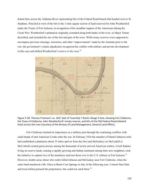
- Page 130 and 131: Figure 5-26. Map showing McMillan
- Page 132 and 133: Figure 5-27. Lowrey’s Store, Post
- Page 134 and 135: Dr. Watkins’s House. Dr. John Wat
- Page 136 and 137: Longmire’s Inn/Fort Warren. Sever
- Page 138 and 139: not be investigated archaeologicall
- Page 140 and 141: Figure 5-35. Anderson Stage Stop in
- Page 144 and 145: When spring 1818 brought more murde
- Page 146 and 147: Figure 5-41. William Weakley’s 18
- Page 148 and 149: Figure 5-44. William Barrett Travis
- Page 150 and 151: Henneberry, 1895), 241-242; Robert
- Page 152 and 153: Figure 6-3. James Weakley’s 1847
- Page 154 and 155: Henry Tanner’s 1823 map of Alabam
- Page 156 and 157: The Old Federal Road spans the nort
- Page 158 and 159: Figure 6-13. Entrenched section of
- Page 160 and 161: Figure 6-14. The Palings stage stop
- Page 162 and 163: the county. The landowners granted
- Page 164 and 165: 1 John Buckner Little, History of B
- Page 166 and 167: Figure 7-2. Federal Road on Thomas
- Page 168 and 169: John Melish’s 1818 map of Alabama
- Page 170 and 171: Figure 7-8. Fletcher Hale’s map d
- Page 172 and 173: Figure 7-11. Old Federal Road and G
- Page 174 and 175: Figure 7-14. Entrenched section of
- Page 176 and 177: morning salute, then turning our ca
- Page 178 and 179: Chapter 8Montgomery CountyTracing t
- Page 180 and 181: Figure 8-4. Old Federal Road (not l
- Page 182 and 183: Figure 8-7. Detail of John Melish
- Page 184 and 185: Fletcher Hale’s maps depict the o
- Page 186 and 187: A short distance beyond where the G
- Page 188 and 189: Where the Old Federal Road crosses
- Page 190 and 191: modern Alabama place names, Opelika
- Page 192 and 193:
stopped “near Macnac’s” to co
- Page 194 and 195:
prairies which you have frequently
- Page 196 and 197:
Figure 8-21. Topographic map with a
- Page 198 and 199:
Figure 8-22. Unit 2 chronologically
- Page 200 and 201:
Pickett says she settled on the eas
- Page 202 and 203:
contained 84 gravesites dating from
- Page 204 and 205:
16 Clarence Edwin Carter, The Terri
- Page 206 and 207:
Figure 9-2. Old Federal Road on Jam
- Page 208 and 209:
Figure 9-5. Detail of an anonymous
- Page 210 and 211:
east onto County Road 2 (Figure 9-9
- Page 212 and 213:
Figure 9-12. The Old Federal Road t
- Page 214 and 215:
Figure 9-15. Dirt segment of Boromv
- Page 216 and 217:
of Little Prince and Opothle Yoholo
- Page 218 and 219:
Redsticks, marched from the Chattah
- Page 220 and 221:
Figure 9-19. Fletcher Hale’s map
- Page 222 and 223:
Warrior’s sons-in-law Captain Wal
- Page 224 and 225:
Chapter 10Russell CountyTracing the
- Page 226 and 227:
Figure 10-3. Detail of Abraham Brad
- Page 228 and 229:
Figure 10-7. Detail of John LaToure
- Page 230 and 231:
Figure 10-10. Old Federal Road on p
- Page 232 and 233:
Figure 10-13. Section of Old Federa
- Page 234 and 235:
Figure 10-16. The Old Federal Road
- Page 236 and 237:
Kendall Lewis, son-in-law of Big Wa
- Page 238 and 239:
Fort Mitchell, Creek Agency, and An
- Page 240 and 241:
A National Cemetery was created at
- Page 242 and 243:
6 Benton, The Very Worst Road, 65-6
- Page 244 and 245:
The Old Federal Road RouteOur archa
- Page 246 and 247:
We have devoted considerable effort
- Page 248 and 249:
Our 1723 Chickasaw map offers a gli
- Page 250 and 251:
of the old-growth forests and to pl
- Page 252 and 253:
Figure 11-6. Detail from David Tait
- Page 254 and 255:
As we have seen, most Americans saw
- Page 256 and 257:
towns and settled for a time at Pol
- Page 258 and 259:
home on the left, the 1902 Hinson h
- Page 260 and 261:
parks or educational centers. The m
- Page 262 and 263:
Appendix 1Extracts from Benjamin Ha
- Page 264 and 265:
E. Bearing east.32 + c. r. 15/ oak
- Page 266 and 267:
N.EBearing northeast.36. path to th
- Page 268 and 269:
Course and Admeasurement2 pole Chai
- Page 270 and 271:
S. 61 E. 17 “N. 83 E. 7 “N. 82
- Page 272 and 273:
E. 16 “S. 83 E. 9 “S. 87 E. 8
- Page 274 and 275:
N. 34 E. 14 “N. 30 E. 16 “N. 24
- Page 276 and 277:
N. 64 E. 9 “N. 40 E. 9 “N. 25 E
- Page 278 and 279:
N. 19 E. 5 “N. 44 E. 7 “[page 5
- Page 280 and 281:
N. 72 E. 16 “N. 71 E. 10 “N. 79
- Page 282 and 283:
N. 77 E. 5 “N. 69 E. 4 “N. 64 E
- Page 284 and 285:
N. 36 E. 7 “N. 54 E. 9 “N. 52 E
- Page 286 and 287:
[page 97]N. 61˚ E. 7 Chains. The S
- Page 288 and 289:
N. 12 E. 7 “N. 32 E. 10 “N. 36
- Page 290 and 291:
N. 66˚ E. 4 ChainsN. 28 E. 7 “N.
- Page 292 and 293:
XIIIIIII. Prairies or Glades the qu
- Page 294 and 295:
N. 27 E. 1 “N. 1 W. 2 “[page 14
- Page 296 and 297:
No 9: Joseph Wheaton to Gideon Gran
- Page 298 and 299:
Blue Spruce, Duane, and Tanya Thras
- Page 300 and 301:
Ethridge, Robbie, Creek Country: Th
- Page 302 and 303:
Potter, Stephen R., and Gregory A.