Archaeological Survey of the Old Federal Road in Alabama
Archaeological Survey of the Old Federal Road in Alabama
Archaeological Survey of the Old Federal Road in Alabama
You also want an ePaper? Increase the reach of your titles
YUMPU automatically turns print PDFs into web optimized ePapers that Google loves.
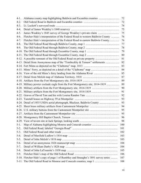
4-1. <strong>Alabama</strong> county map highlight<strong>in</strong>g Baldw<strong>in</strong> and Escambia counties ............................. 724-2. <strong>Old</strong> <strong>Federal</strong> <strong>Road</strong> <strong>in</strong> Baldw<strong>in</strong> and Escambia counties ................................................... 724-3. Lt. Luckett’s surveyed route ........................................................................................... 744-4. Detail <strong>of</strong> James Weakley’s 1848 resurvey ..................................................................... 754-5. James Weakley’s 1845 survey <strong>of</strong> George Weakley’s private claim .............................. 754-6. Fletcher Hale’s <strong>in</strong>terpretation <strong>of</strong> <strong>the</strong> <strong>Federal</strong> <strong>Road</strong> <strong>in</strong> western Baldw<strong>in</strong> County ........... 764-7. Fletcher Hale’s <strong>in</strong>terpretation <strong>of</strong> <strong>the</strong> <strong>Federal</strong> <strong>Road</strong> <strong>in</strong> eastern Baldw<strong>in</strong> County .............. 764-8. The <strong>Old</strong> <strong>Federal</strong> <strong>Road</strong> through Baldw<strong>in</strong> County, map 1 ................................................ 774-9. The <strong>Old</strong> <strong>Federal</strong> <strong>Road</strong> through Baldw<strong>in</strong> County, map 2 ................................................ 784-10. The <strong>Old</strong> <strong>Federal</strong> <strong>Road</strong> through Escambia County, map 1 .............................................. 794-11. The <strong>Old</strong> <strong>Federal</strong> <strong>Road</strong> through Escambia County, map 2 .............................................. 804-12. A possible remnant <strong>of</strong> <strong>the</strong> <strong>Old</strong> <strong>Federal</strong> <strong>Road</strong> on private property .................................. 814-13. Detail from Anonymous map <strong>of</strong> <strong>the</strong> “Tombeckby & Tensaw” settlements ................... 824-14. Fort Mims as depicted on <strong>the</strong> “Claiborne” map, 1813 ................................................... 834-15. Mims’ Ferry, as depicted on a detail <strong>of</strong> <strong>the</strong> “Claiborne” map ........................................ 844-16. View <strong>of</strong> <strong>the</strong> old Mims’s ferry land<strong>in</strong>g from <strong>the</strong> <strong>Alabama</strong> River .................................... 854-17. Detail from Melish map <strong>of</strong> <strong>Alabama</strong> Territory, 1818 .................................................... 874-18. Artifacts from <strong>the</strong> Fort Montgomery site, 1814-1819 .................................................... 894-19. Military pewter cockade eagle from <strong>the</strong> Fort Montgomery site, 1814-1819 .................. 894-20. Military artifacts from <strong>the</strong> Fort Montgomery site, 1814-1819 ....................................... 904-21. Military artifacts from <strong>the</strong> Fort Montgomery site, 1814-1819 ........................................ 914-22. Graves <strong>of</strong> David Tate and his wife Louisa Randon Tate ................................................ 924-23. Tunstall house on Highway 59 at Montpelier ................................................................ 934-24. Detail <strong>of</strong> 1955 USDA aerial photograph, Blackser, Baldw<strong>in</strong> County ............................ 934-25. Sheet brass military artifacts from Cantonment Montpelier .......................................... 944-26. U.S. military buttons from <strong>the</strong> Cantonment Montpelier site .......................................... 954-27. Artifacts from <strong>the</strong> Cantonment Montpelier site .............................................................. 954-28. Montgomery Hill Baptist Church, Tensaw ..................................................................... 964-29. View <strong>of</strong> tavern site at Jack Spr<strong>in</strong>gs, look<strong>in</strong>g south ......................................................... 985-1. Map <strong>of</strong> <strong>Alabama</strong> highlight<strong>in</strong>g Monroe and Conecuh counties ..................................... 1005-2. <strong>Old</strong> <strong>Federal</strong> <strong>Road</strong>, labeled “Georgia <strong>Road</strong>” ................................................................. 1015-3. <strong>Old</strong> <strong>Federal</strong> <strong>Road</strong> and o<strong>the</strong>r roads ................................................................................ 1025-4. Detail <strong>of</strong> Maxfield Ludlow’s 1816 map ....................................................................... 1035-5. Detail <strong>of</strong> John Melish’s 1818 map ................................................................................ 1035-6. Detail <strong>of</strong> an anonymous 1826 manuscript map ............................................................ 1045-7. Detail <strong>of</strong> William Darby’s 1828 map ........................................................................... 1045-8. Detail <strong>of</strong> John LaTourette’s 1838 map ......................................................................... 1055-9. Fletcher Hale’s map <strong>of</strong> <strong>the</strong> <strong>Old</strong> <strong>Federal</strong> <strong>Road</strong> .............................................................. 1065-10. Fletcher Hale’s copy <strong>of</strong> page 1 <strong>of</strong> Rumbley and Straughn’s 1891 survey notes .......... 1075-11. The <strong>Old</strong> <strong>Federal</strong> <strong>Road</strong> <strong>in</strong> Monroe and Conecuh counties, map 1 ................................. 108vi


