Archaeological Survey of the Old Federal Road in Alabama
Archaeological Survey of the Old Federal Road in Alabama
Archaeological Survey of the Old Federal Road in Alabama
You also want an ePaper? Increase the reach of your titles
YUMPU automatically turns print PDFs into web optimized ePapers that Google loves.
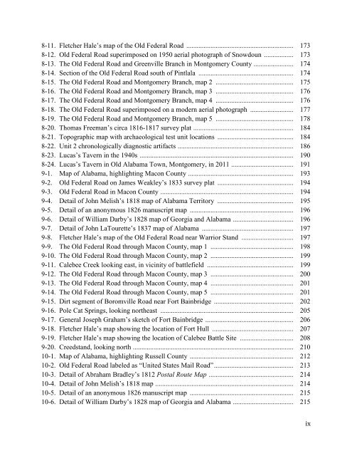
8-11. Fletcher Hale’s map <strong>of</strong> <strong>the</strong> <strong>Old</strong> <strong>Federal</strong> <strong>Road</strong> .............................................................. 1738-12. <strong>Old</strong> <strong>Federal</strong> <strong>Road</strong> superimposed on 1950 aerial photograph <strong>of</strong> Snowdoun ................. 1738-13. The <strong>Old</strong> <strong>Federal</strong> <strong>Road</strong> and Greenville Branch <strong>in</strong> Montgomery County ....................... 1748-14. Section <strong>of</strong> <strong>the</strong> <strong>Old</strong> <strong>Federal</strong> <strong>Road</strong> south <strong>of</strong> P<strong>in</strong>tlala ....................................................... 1748-15. The <strong>Old</strong> <strong>Federal</strong> <strong>Road</strong> and Montgomery Branch, map 2 ............................................. 1758-16. The <strong>Old</strong> <strong>Federal</strong> <strong>Road</strong> and Montgomery Branch, map 3 ............................................. 1768-17. The <strong>Old</strong> <strong>Federal</strong> <strong>Road</strong> and Montgomery Branch, map 4 ............................................. 1768-18. The <strong>Old</strong> <strong>Federal</strong> <strong>Road</strong> superimposed on a modern aerial photograph ......................... 1778-19. The <strong>Old</strong> <strong>Federal</strong> <strong>Road</strong> and Montgomery Branch, map 5 ............................................. 1788-20. Thomas Freeman’s circa 1816-1817 survey plat .......................................................... 1848-21. Topographic map with archaeological test unit locations ............................................ 1848-22. Unit 2 chronologically diagnostic artifacts ................................................................... 1868-23. Lucas’s Tavern <strong>in</strong> <strong>the</strong> 1940s ......................................................................................... 1908-24. Lucas’s Tavern <strong>in</strong> <strong>Old</strong> <strong>Alabama</strong> Town, Montgomery, <strong>in</strong> 2011 .................................... 1919-1. Map <strong>of</strong> <strong>Alabama</strong>, highlight<strong>in</strong>g Macon County ............................................................. 1939-2. <strong>Old</strong> <strong>Federal</strong> <strong>Road</strong> on James Weakley’s 1833 survey plat ............................................ 1949-3. <strong>Old</strong> <strong>Federal</strong> <strong>Road</strong> <strong>in</strong> Macon County ............................................................................. 1949-4. Detail <strong>of</strong> John Melish’s 1818 map <strong>of</strong> <strong>Alabama</strong> Territory ............................................ 1959-5. Detail <strong>of</strong> an anonymous 1826 manuscript map ............................................................ 1969-6. Detail <strong>of</strong> William Darby’s 1828 map <strong>of</strong> Georgia and <strong>Alabama</strong> ................................... 1969-7. Detail <strong>of</strong> John LaTourette’s 1837 map <strong>of</strong> <strong>Alabama</strong> ..................................................... 1979-8. Fletcher Hale’s map <strong>of</strong> <strong>the</strong> <strong>Old</strong> <strong>Federal</strong> <strong>Road</strong> near Warrior Stand .............................. 1979-9. The <strong>Old</strong> <strong>Federal</strong> <strong>Road</strong> through Macon County, map 1 ................................................ 1989-10. The <strong>Old</strong> <strong>Federal</strong> <strong>Road</strong> through Macon County, map 2 ................................................ 1999-11. Calebee Creek look<strong>in</strong>g east, <strong>in</strong> vic<strong>in</strong>ity <strong>of</strong> battlefield .................................................. 1999-12. The <strong>Old</strong> <strong>Federal</strong> <strong>Road</strong> through Macon County, map 3 ................................................ 2009-13. The <strong>Old</strong> <strong>Federal</strong> <strong>Road</strong> through Macon County, map 4 ................................................ 2019-14. The <strong>Old</strong> <strong>Federal</strong> <strong>Road</strong> through Macon County, map 5 ................................................ 2019-15. Dirt segment <strong>of</strong> Boromville <strong>Road</strong> near Fort Ba<strong>in</strong>bridge .............................................. 2029-16. Pole Cat Spr<strong>in</strong>gs, look<strong>in</strong>g nor<strong>the</strong>ast ............................................................................. 2059-17. General Joseph Graham’s sketch <strong>of</strong> Fort Ba<strong>in</strong>bridge ................................................... 2069-18. Fletcher Hale’s map show<strong>in</strong>g <strong>the</strong> location <strong>of</strong> Fort Hull ............................................... 2079-19. Fletcher Hale’s map show<strong>in</strong>g <strong>the</strong> location <strong>of</strong> Calebee Battle Site ............................... 2089-20. Creedstand, look<strong>in</strong>g north ............................................................................................. 21010-1. Map <strong>of</strong> <strong>Alabama</strong>, highlight<strong>in</strong>g Russell County ............................................................ 21210-2. <strong>Old</strong> <strong>Federal</strong> <strong>Road</strong> labeled as “United States Mail <strong>Road</strong>” .............................................. 21310-3. Detail <strong>of</strong> Abraham Bradley’s 1812 Postal Route Map ................................................. 21410-4. Detail <strong>of</strong> John Melish’s 1818 map ................................................................................ 21410-5. Detail <strong>of</strong> an anonymous 1826 manuscript map ............................................................ 21510-6. Detail <strong>of</strong> William Darby’s 1828 map <strong>of</strong> Georgia and <strong>Alabama</strong> ................................... 215ix


