

the earth observation handbook
The Earth Observation Handbook - Key Tables - SEOCA
The Earth Observation Handbook - Key Tables - SEOCA
- No tags were found...

Create successful ePaper yourself
Turn your PDF publications into a flip-book with our unique Google optimized e-Paper software.
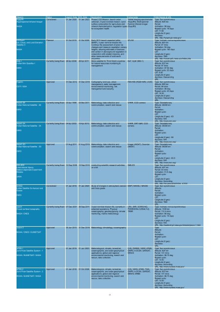
Mission Status Launch Date EOL Date Applications Instruments Orbit Details & URL<br />
HyspIRI<br />
Visible imaging spectrometer<br />
Hyperspectral Infrared Imager<br />
(HyspIRI), Multi-spectral<br />
NASA<br />
ICESat-II<br />
Ice, Cloud, and Land Elevation<br />
Satellite II<br />
NASA<br />
IMS-1<br />
Indian Mini Satellite-1<br />
ISRO<br />
Ingenio<br />
CDTI / ESA<br />
INSAT-2E<br />
Indian National Satellite - 2E<br />
ISRO<br />
INSAT-3A<br />
Indian National Satellite - 3A<br />
ISRO<br />
INSAT-3D<br />
Indian National Satellite - 3D<br />
ISRO<br />
ISS/JEM<br />
International Space<br />
Station/Japanese Experiment<br />
Module<br />
JAXA<br />
ISTAG<br />
Indian Satellite for Aerosol and<br />
Gases<br />
ISRO<br />
Jason<br />
Ocean surface topography<br />
NASA / CNES<br />
Jason-3<br />
NOAA / CNES / EUMETSAT<br />
JPSS-1<br />
Joint Polar Satellite System - 1<br />
NOAA / EUMETSAT / NASA<br />
JPSS-2<br />
Joint Polar Satellite System - 2<br />
NOAA / EUMETSAT / NASA<br />
Considered 01 Jan 2020 01 Jan 2023 Phase-2 DS Mission, launch order<br />
unknown, 3-year nominal mission. Land<br />
surface composition for agriculture and<br />
mineral characterization; vegetation types<br />
for ecosystem health<br />
<strong>the</strong>rmal infrared imager<br />
(HyspIRI)<br />
Planned 31 Oct 2015 31 Oct 2020 Early 2015 launch expected (after<br />
SMAP), 3-year nominal mission life.<br />
Continue <strong>the</strong> assessment of polar ice<br />
changes and measure vegetation canopy<br />
heights, allowing estimates of biomass<br />
and carbon in aboveground vegetation in<br />
conjunction with related missions, and<br />
allow measurements of solid <strong>earth</strong><br />
properties.<br />
ATLAS<br />
Currently being flown 28 Apr 2008 28 Apr 2011 Micro-satellite for Third World countries MxT, HySI (IMS-1)<br />
for natural resources monitoring &<br />
management<br />
Approved 31 Dec 2012 31 Dec 2019 Cartography, land use, urban<br />
management, water management,<br />
environmental monitoring, risk<br />
management and security.<br />
Currently being flown 03 Apr 1999 04 Mar 2011 Meteorology, data collection and<br />
communication, search and rescue<br />
Currently being flown 04 Apr 2003 10 Apr 2013 Meteorology, data collection and<br />
communication, search and rescue<br />
Approved 01 Aug 2011 01 Aug 2018 Meteorology, data collection and<br />
communication, search and rescue<br />
Currently being flown 10 Sep 2009 10 Sep 2010 conducting scientific research activities<br />
on orbit<br />
Considered 01 Jan 2015 01 Jan 2020 Study of changes in atmospheric aerosol<br />
and trace gases<br />
Currently being flown 07 Dec 2001 30 Sep 2011 3-year nominal mission life, currently in<br />
extended operations. Physical<br />
oceanography, geodesy/gravity, climate<br />
monitoring, marine meteorology<br />
PAN+MS (RGB+NIR), UVAS<br />
VHRR, CCD camera<br />
VHRR, DRT-S&R, CCD<br />
camera<br />
Imager (INSAT), Sounder<br />
(INSAT)<br />
SMILES<br />
MAPI, MAVELI, MAGIS<br />
LRA, JMR, DORIS-NG,<br />
POSEIDON-2 (SSALT-2),<br />
TRSR<br />
Type: Sun-synchronous<br />
Altitude: 626 km<br />
Period:<br />
Inclination: 98 deg<br />
Repeat cycle: 19 days<br />
LST: 11:00<br />
Longitude (if geo):<br />
Asc/desc:<br />
URL: http://hyspiri.jpl.nasa.gov/<br />
Approved 30 Jun 2013 31 Dec 2018 Meteorology, climatology, oceanography Type:<br />
Altitude:<br />
Period:<br />
Inclination:<br />
Repeat cycle:<br />
LST:<br />
Longitude (if geo):<br />
Asc/desc:<br />
URL:<br />
Approved 01 Jan 2015 01 Jun 2023 Meteorological, climatic, terrestrial,<br />
oceanographic, and solar-geophysical<br />
applications; global and regional<br />
environmental monitoring, search and<br />
rescue, data collection.<br />
Approved 01 Jan 2018 01 Oct 2026 Meteorological, climatic, terrestrial,<br />
oceanographic, and solar-geophysical<br />
applications; global and regional<br />
environmental monitoring, search and<br />
rescue, data collection.<br />
CrIS, CERES, VIIRS, ATMS,<br />
OMPS, A-DCS4, SARSAT,<br />
SEM-N<br />
CrIS, VIIRS, ATMS, TSIS,<br />
OMPS, A-DCS4, SARSAT,<br />
SEM-N, ERBS<br />
Type: Inclined, non-sunsynchronous<br />
Altitude: 600 km<br />
Period: 97 mins<br />
Inclination: 94 deg<br />
Repeat cycle: 183 days<br />
LST:<br />
Longitude (if geo):<br />
Asc/desc: TBD<br />
URL: http://icesat.gsfc.nasa.gov/index.php<br />
Type: Sun-synchronous<br />
Altitude: 632 km<br />
Period: 97 mins<br />
Inclination: 97.92 deg<br />
Repeat cycle: 22 days<br />
LST: 9:30<br />
Longitude (if geo):<br />
Asc/desc: Descending<br />
URL:<br />
Type: Sun-synchronous<br />
Altitude: 668 km<br />
Period: 98 mins<br />
Inclination: 98 deg<br />
Repeat cycle: 43 days<br />
LST: 10:30<br />
Longitude (if geo):<br />
Asc/desc: Descending<br />
URL:<br />
Type: Geostationary<br />
Altitude: 36000 km<br />
Period:<br />
Inclination:<br />
Repeat cycle:<br />
LST:<br />
Longitude (if geo): -83<br />
Asc/desc: N/A<br />
URL: http://www.isro.org/<br />
Type: Geostationary<br />
Altitude: 36000 km<br />
Period:<br />
Inclination:<br />
Repeat cycle:<br />
LST:<br />
Longitude (if geo): -94<br />
Asc/desc: N/A<br />
URL: http://www.isro.org/<br />
Type: Geostationary<br />
Altitude: 36000 km<br />
Period:<br />
Inclination:<br />
Repeat cycle:<br />
LST:<br />
Longitude (if geo): -93.5<br />
Asc/desc: N/A<br />
URL: http://www.isro.org/<br />
Type: Sun-synchronous<br />
Altitude: 407 km<br />
Period: 93 mins<br />
Inclination: 51.6 deg<br />
Repeat cycle:<br />
LST:<br />
Longitude (if geo):<br />
Asc/desc: Ascending<br />
URL: http://iss.jaxa.jp/iss/index_e.html<br />
Type: Sun-synchronous<br />
Altitude:<br />
Period:<br />
Inclination:<br />
Repeat cycle:<br />
LST:<br />
Longitude (if geo):<br />
Asc/desc: TBD<br />
URL:<br />
Type: Inclined, non-sunsynchronous<br />
Altitude: 1336 km<br />
Period: 112.4 mins<br />
Inclination: 66 deg<br />
Repeat cycle: 10 days<br />
LST:<br />
Longitude (if geo):<br />
Asc/desc: N/A<br />
URL: http://sealevel.jpl.nasa.gov/mission/jason-1.html<br />
Type: Sun-synchronous<br />
Altitude: 824 km<br />
Period: 101 mins<br />
Inclination: 98.75 deg<br />
Repeat cycle:<br />
LST: 13:30<br />
Longitude (if geo):<br />
Asc/desc: Ascending<br />
URL: http://www.npoess.noaa.gov/<br />
Type: Sun-synchronous<br />
Altitude: 833 km<br />
Period: 101 mins<br />
Inclination: 98.75 deg<br />
Repeat cycle:<br />
LST: 13:30<br />
Longitude (if geo):<br />
Asc/desc: Ascending<br />
URL: http://www.npoess.noaa.gov/<br />
13


