

the earth observation handbook
The Earth Observation Handbook - Key Tables - SEOCA
The Earth Observation Handbook - Key Tables - SEOCA
- No tags were found...

You also want an ePaper? Increase the reach of your titles
YUMPU automatically turns print PDFs into web optimized ePapers that Google loves.
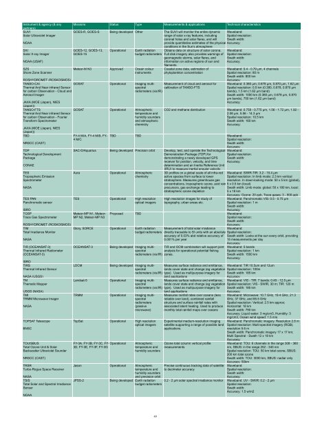
Instrument & agency (& any<br />
partners)<br />
SUVI<br />
Solar Ultraviolet Imager<br />
NOAA<br />
SXI<br />
Solar X-ray Imager<br />
NOAA (USAF)<br />
SZS<br />
Shore Zone Scanner<br />
JAXA (MOE (Japan), NIES<br />
(Japan))<br />
TANSO-FTS<br />
Thermal And Near infrared Sensor<br />
for carbon Observation - Fourier<br />
Transform Spectrometer<br />
Missions Status Type Measurements & applications Technical characteristics<br />
GOES-R, GOES-S Being developed O<strong>the</strong>r The SUVI will monitor <strong>the</strong> entire dynamic<br />
range of solar x-ray features, including<br />
coronal holes and solar flares, and will<br />
Waveband:<br />
Spatial resolution:<br />
Swath width:<br />
provide quantitative estimates of <strong>the</strong> physical Accuracy:<br />
conditions in <strong>the</strong> Sun’s atmosphere<br />
GOES-12, GOES-13,<br />
GOES-15<br />
Operational<br />
Earth radiation<br />
budget radiometers<br />
Meteor-M N3 Approved Ocean colour<br />
instruments<br />
Obtains data on structure of solar corona.<br />
Full disk imagery also provides warnings of<br />
geomagnetic storms, solar flares, and<br />
information on active regions of sun and<br />
filaments<br />
Coastal zone data, estimation of<br />
phytoplankton concentration<br />
ROSHYDROMET (ROSKOSMOS)<br />
TANSO-CAI<br />
GOSAT Operational Imaging multispectral<br />
Measurement of cloud and aerosol for<br />
Thermal And Near infrared Sensor<br />
calibration of TANSO-FTS<br />
for carbon Observation - Cloud and<br />
radiometers (vis/IR)<br />
Aerosol Imager<br />
JAXA (MOE (Japan), NIES<br />
(Japan))<br />
TBD<br />
NRSCC (CAST)<br />
TDP<br />
Technological Development<br />
Package<br />
CONAE<br />
TES<br />
Tropospheric Emission<br />
Spectrometer<br />
NASA<br />
TES PAN<br />
Panchromatic sensor<br />
ISRO<br />
TGSP<br />
Trace Gas Spectrometer<br />
ROSHYDROMET (ROSKOSMOS)<br />
TIM<br />
Total Irradiance Monitor<br />
NASA<br />
TIR (OCEANSAT-3)<br />
Thermal Infrared Radiometer<br />
(OCEANSAT-3)<br />
ISRO<br />
TIRS<br />
Thermal Infrared Sensor<br />
NASA (USGS)<br />
TM<br />
Thematic Mapper<br />
USGS (NASA)<br />
TMI<br />
TRMM Microwave Imager<br />
NASA<br />
TOPSAT Telescope<br />
BNSC<br />
TOU/SBUS<br />
Total Ozone Unit & Solar<br />
Backscatter Ultraviolet Sounder<br />
NRSCC (CAST)<br />
TRSR<br />
Turbo-Rogue Space Receiver<br />
GOSAT Operational Atmospheric<br />
temperature and<br />
humidity sounders<br />
and atmospheric<br />
chemistry<br />
FY-4 M/A, FY-4 M/B, FY-<br />
4 M/C<br />
Waveband:<br />
Spatial resolution:<br />
Swath width:<br />
Accuracy:<br />
Waveband: 0.4 - 0.79 µm, 4 channels<br />
Spatial resolution: 80 m<br />
Swath width: 800 km<br />
Accuracy:<br />
Waveband: 0.380 µm, 0.678 µm, 0.870 µm, 1.62 µm<br />
Spatial resolution: 0.5 km (0.380, 0.678, 0.870 µm<br />
bands), 1.5 km (1.62 µm band)<br />
Swath width: 1000 km (0.380 µm, 0.678 µm, 0.870<br />
µm bands), 750 km (1.62 µm band)<br />
Accuracy:<br />
CO2 and methane distribution Waveband: 0.758 - 0.775 µm, 1.56 - 1.72 µm, 1.92 -<br />
2.08 µm, 5.56 - 14.3 µm<br />
Spatial resolution: 10.5 km<br />
Swath width: 160 km<br />
Accuracy:<br />
TBD TBD Waveband:<br />
Spatial resolution:<br />
Swath width:<br />
Accuracy:<br />
SAC-D/Aquarius Being developed Precision orbit Develop, test, and operate <strong>the</strong> Technological Waveband:<br />
Demonstration Package (TDP) for<br />
demonstrating a newly developed GPS<br />
receiver for position, velocity, and time<br />
Spatial resolution:<br />
Swath width:<br />
Accuracy:<br />
determination and an Inertia Reference Unit<br />
(IRU) to measure inertial angular velocity<br />
Aura Operational Atmospheric<br />
chemistry<br />
TES Operational High resolution<br />
optical imagers<br />
Meteor-MP N1, Meteor-<br />
MP N2, Meteor-MP N3<br />
3D profiles on a global scale of all infra-red<br />
active species from surface to lower<br />
stratosphere. Measures greenhouse gas<br />
concentrations, tropospheric ozone, acid rain<br />
precursors, gas exchange leading to<br />
stratospheric ozone depletion<br />
High resolution images for study of<br />
topography, urban areas etc.<br />
Proposed TBD Waveband:<br />
Spatial resolution:<br />
Swath width:<br />
Accuracy:<br />
Waveband: SWIR-TIR: 3.2 - 15.4 µm<br />
Spatial resolution: In limb mode: 2.3 km vertical<br />
resolution. In down-looking mode: 50 x 5 km (global),<br />
5 x 0.5 km (local)<br />
Swath width: Limb mode: global: 50 x 180 km, local:<br />
5 x 18 km<br />
Accuracy: Ozone: 20 ppb, Trace gases: 3 - 500 ppb<br />
Waveband: Panchromatic VIS: 0.5 - 0.75 µm<br />
Spatial resolution: 1 m<br />
Swath width:<br />
Accuracy:<br />
Glory, SORCE Operational Earth radiation Measurement of total solar irradiance Waveband:<br />
budget radiometers directly traceable to SI units with an absolute Spatial resolution:<br />
accuracy of 0.03% abd relative accuracy of<br />
0.001% per year<br />
Swath width: Looks at <strong>the</strong> sun every orbit, providing<br />
15 measurements per day<br />
Accuracy:<br />
OCEANSAT-3<br />
LDCM<br />
NASA<br />
TSIS<br />
JPSS-2<br />
Total Solar and Spectral Irradiance<br />
Sensor<br />
NOAA<br />
Being developed Imaging multispectral<br />
analysis for operational potential fishing<br />
TIR and OCM combination will support joint<br />
radiometers (vis/IR) zones.<br />
Being developed Imaging multispectral<br />
radiometers (vis/IR)<br />
Landsat-5 Operational Imaging multispectral<br />
radiometers (vis/IR)<br />
TRMM Operational Imaging multispectral<br />
radiometers<br />
(passive<br />
microwave)<br />
TopSat Operational High resolution<br />
optical imagers<br />
FY-3A, FY-3B, FY-3C, FY- Operational<br />
3D, FY-3E, FY-3F, FY-3G<br />
Atmospheric<br />
temperature and<br />
humidity sounders<br />
Jason Operational Atmospheric<br />
temperature and<br />
humidity sounders<br />
and precision orbit<br />
Being developed Earth radiation<br />
budget radiometers<br />
Measures surface radiance and emittance,<br />
lands cover state and change (eg vegetation<br />
type). Used as multipurpose imagery for<br />
land applications<br />
Measures surface radiance and emittance,<br />
lands cover state and change (eg vegetation<br />
type). Used as multipurpose imagery for<br />
land applications<br />
Measures rainfall rates over oceans (less<br />
reliable over land), combined rainfall<br />
structure and surface rainfall rates with<br />
associated latent heating. Used to produce<br />
monthly total rainfall maps over oceans<br />
Experimental medium-resolution imaging<br />
satellite supporting a range of possible land<br />
applications.<br />
Ozone total column vertical profile<br />
measurements<br />
Precise continuous tracking data of satellite<br />
to decimeter accuracy<br />
Waveband: 5 bands<br />
Spatial resolution: 1 km<br />
Swath width: 1500 km<br />
Accuracy:<br />
Waveband: TIR 10.5um and 12um<br />
Spatial resolution: 100m<br />
Swath width: 185 km<br />
Accuracy:<br />
Waveband: VIS - TIR: 7 bands: 0.45 - 12.5 µm<br />
Spatial resolution: VIS - SWIR, 30 m; TIR: 120 m<br />
Swath width: 185 km<br />
Accuracy:<br />
Waveband: Microwave: 10.7 GHz, 19.4 GHz, 21.3<br />
GHz, 37 GHz, and 85.5 GHz<br />
Spatial resolution: Vertical: 2.5 km approx;<br />
Horizontal: 18 km<br />
Swath width: 790 km<br />
Accuracy: Liquid water: 3 mg/cm3, Humidity: 3<br />
mg/cm3, Ocean wind speed: 1.5 m/s<br />
Waveband: Panchromatic imagery. Resolution 2.8 m<br />
Spatial resolution: Multi-spectral imagery (RGB).<br />
resolution 5.6 m<br />
Swath width: Panchromatic imagery 17 x 17 km;<br />
Multi Spectral - Swath 12 x 18 km<br />
Accuracy:<br />
Waveband: TOU: 6 channels in <strong>the</strong> range 308 - 360<br />
nm, SBUS: in <strong>the</strong> range 252 - 340 nm<br />
Spatial resolution: TOU: 50 km total ozone, SBUS:<br />
200 km total ozone<br />
Swath width: TOU: 3000 km, SBUS: nadiar only<br />
Accuracy: 50km<br />
Waveband:<br />
Spatial resolution:<br />
Swath width:<br />
Accuracy:<br />
0.2 - 2 µm solar spectral irradiance monitor Waveband: UV - SWIR: 0.2 - 2 µm<br />
Spatial resolution:<br />
Swath width:<br />
Accuracy: 1.5 w/m2<br />
49


