

the earth observation handbook
The Earth Observation Handbook - Key Tables - SEOCA
The Earth Observation Handbook - Key Tables - SEOCA
- No tags were found...

Create successful ePaper yourself
Turn your PDF publications into a flip-book with our unique Google optimized e-Paper software.
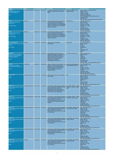
Mission Status Launch Date EOL Date Applications Instruments Orbit Details & URL<br />
CryoSat-2<br />
CryoSat-2 (Earth Explorer<br />
Opportunity Mission)<br />
ESA<br />
Currently being flown 08 Apr 2010 08 Jul 2013 To determine fluctuations in <strong>the</strong> mass of<br />
<strong>the</strong> Earth’s major land and marine ice<br />
fields.<br />
DORIS-NG, SIRAL, Laser<br />
Reflectors (ESA)<br />
Type: Inclined, non-sunsynchronous<br />
Altitude: 717 km<br />
Period: 100 mins<br />
Inclination: 92 deg<br />
Repeat cycle: 369 days<br />
LST: 0.25 degree nodal regression per day<br />
Longitude (if geo):<br />
Asc/desc: N/A<br />
URL: http://www.esa.int/export/esaLP/cryosat.html<br />
CSG-1<br />
COSMO-SkyMed Second<br />
Generation - 1<br />
ASI / MiD (Italy)<br />
CSG-2<br />
COSMO-SkyMed Second<br />
Generation - 2<br />
ASI / MiD (Italy)<br />
D/F Climate Mission<br />
Methane Remote Sensing LIDAR<br />
Mission<br />
DLR / CNES<br />
DEMETER<br />
Detection of Electro-Magnetic<br />
Emissions Transmitted from<br />
Earthquake Regions<br />
CNES<br />
DESDynI<br />
Deformation, Ecosystem,<br />
Structure, and Dynamics of Ice<br />
NASA<br />
Diademe 1&2<br />
CNES<br />
DMSP F-14<br />
Defense Meteorological Satellite<br />
Program F-14<br />
NOAA<br />
DMSP F-15<br />
Defense Meteorological Satellite<br />
Program F-15<br />
NOAA<br />
DMSP F-16<br />
Defense Meteorological Satellite<br />
Program F-16<br />
NOAA<br />
DMSP F-17<br />
Defense Meteorological Satellite<br />
Program F-17<br />
NOAA<br />
DMSP F-18<br />
Defense Meteorological Satellite<br />
Program F-18<br />
NOAA<br />
DMSP F-19<br />
Defense Meteorological Satellite<br />
Program F-19<br />
NOAA<br />
Approved 30 Apr 2014 30 Oct 2021 Environmental monitoring, surveillance<br />
and risk management applications,<br />
environmental resources management,<br />
maritime management, <strong>earth</strong> topographic<br />
mapping, law enforcement, informative /<br />
science applications<br />
SAR-2000 S.G.<br />
Approved 30 Apr 2015 30 Oct 2022 Environmental monitoring, surveillance<br />
and risk management applications,<br />
environmental resources management,<br />
maritime management, <strong>earth</strong> topographic<br />
mapping, law enforcement, informative /<br />
science applications<br />
SAR-2000 S.G.<br />
Planned 01 Jan 2014 01 Jan 2017 Global atmospheric Methane<br />
concentration.<br />
Currently being flown 29 Jun 2004 31 Dec 2010 Micro-satellite to study; ionospheric<br />
disturbances related to seismic activity,<br />
ionospheric disturbances related to<br />
human activity, pre and post-seismic<br />
effects in <strong>the</strong> ionosphere, global<br />
information on <strong>the</strong> Earth's<br />
electromagnetic environment<br />
Considered 30 Oct 2017 30 Oct 2020 Phase-1 DS Mission (follows SMAP and<br />
ICESAT-2), 3-year nominal mission.<br />
Surface and ice sheet deformation for<br />
understanding natural hazards and<br />
climate; vegetation structure for<br />
ecosystem health<br />
Currently being flown 15 Feb 1967 31 Dec 2050 Geodetic measurements using satellite<br />
laser ranging<br />
IPDA LIDAR<br />
ICE, IMSC, IAP, ISL, IDP<br />
Multi-beam LIDAR (Desdyni),<br />
L-band INSAR (DESdynI)<br />
Currently being flown 04 Apr 1997 01 Oct 2010 The long-term meteorological programme OLS, SSM/I, SSM/T-1, SSM/Tof<br />
<strong>the</strong> US Department of Defense (DoD) - 2, SSB/X-2, SSI/ES-2, SSJ/4,<br />
with <strong>the</strong> objective to collect and SSM<br />
disseminate worldwide atmospheric,<br />
oceanographic, solar-geophyscial, and<br />
cloud cover data on a daily basis.<br />
Currently being flown 12 Dec 1999 01 May 2013 The long-term meteorological programme OLS, SSM/I, SSM/T-1, SSM/Tof<br />
<strong>the</strong> US Department of Defense (DoD) - 2, SSI/ES-2, SSJ/4, SSM<br />
with <strong>the</strong> objective to collect and<br />
disseminate worldwide cloud cover data<br />
on a daily basis. (Primary operational<br />
satellite)<br />
Currently being flown 18 Oct 2003 01 Oct 2011 The long-term meteorological programme OLS, SSM/IS, SSM, SSI/ESof<br />
<strong>the</strong> US Department of Defense (DoD) - 3, SSJ/5, SSULI, SSUSI<br />
with <strong>the</strong> objective to collect and<br />
disseminate worldwide cloud cover data<br />
on a daily basis.<br />
Currently being flown 04 Nov 2006 01 Jun 2013 The long-term meteorological programme OLS, SSM/IS, SSM, SSI/ESof<br />
<strong>the</strong> US Department of Defense (DoD) - 3, SSULI, SSUSI<br />
with <strong>the</strong> objective to collect and<br />
disseminate worldwide cloud cover data<br />
on a daily basis.<br />
Currently being flown 18 Oct 2009 01 Apr 2014 The long-term meteorological programme OLS, SSM/IS, SSM, SSI/ESof<br />
<strong>the</strong> US Department of Defense (DoD) - 3, SSULI, SSUSI<br />
with <strong>the</strong> objective to collect and<br />
disseminate worldwide cloud cover data<br />
on a daily basis.<br />
Approved 01 Oct 2012 01 Oct 2017 The long-term meteorological programme OLS, SSM/IS, SSM, SSI/ESof<br />
<strong>the</strong> US Department of Defense (DoD) - 3, SSULI, SSUSI<br />
with <strong>the</strong> objective to collect and<br />
disseminate worldwide cloud cover data<br />
on a daily basis.<br />
RRA<br />
Type: Sun-synchronous<br />
Altitude: 620 km<br />
Period: 97.1 mins<br />
Inclination: 97.8 deg<br />
Repeat cycle: 16 days<br />
LST: 6:00<br />
Longitude (if geo):<br />
Asc/desc: Ascending<br />
URL: http://www.asi.it<br />
Type: Sun-synchronous<br />
Altitude: 620 km<br />
Period: 97.1 mins<br />
Inclination: 97.8 deg<br />
Repeat cycle: 16 days<br />
LST: 6:00<br />
Longitude (if geo):<br />
Asc/desc: Ascending<br />
URL: http://www.asi.it<br />
Type: Sun-synchronous<br />
Altitude: 650 km<br />
Period:<br />
Inclination:<br />
Repeat cycle:<br />
LST:<br />
Longitude (if geo):<br />
Asc/desc:<br />
URL:<br />
Type: Sun-synchronous<br />
Altitude: 800 km<br />
Period:<br />
Inclination:<br />
Repeat cycle:<br />
LST: 10:30<br />
Longitude (if geo):<br />
Asc/desc: TBD<br />
URL: http://smsc.cnes.fr/DEMETER/index.htm<br />
Type: Sun-synchronous<br />
Altitude: 400 km<br />
Period:<br />
Inclination: 97 deg<br />
Repeat cycle: 8 days<br />
LST: 6:00<br />
Longitude (if geo):<br />
Asc/desc: Ascending<br />
URL: http://desdyni.jpl.nasa.gov/<br />
Type: Inclined, non-sunsynchronous<br />
Altitude: 1200 km<br />
Period: 108 mins<br />
Inclination: 40 deg<br />
Repeat cycle:<br />
LST:<br />
Longitude (if geo):<br />
Asc/desc: TBD<br />
URL: http://galileo.crl.go.jp/ilrs/diademe.html<br />
Type: Sun-synchronous<br />
Altitude: 833 km<br />
Period: 101 mins<br />
Inclination: 98.7 deg<br />
Repeat cycle:<br />
LST: 20:29<br />
Longitude (if geo):<br />
Asc/desc: Ascending<br />
URL: http://dmsp.ngdc.noaa.gov/dmsp.html<br />
Type: Sun-synchronous<br />
Altitude: 833 km<br />
Period: 101 mins<br />
Inclination: 98.9 deg<br />
Repeat cycle:<br />
LST: 20:29<br />
Longitude (if geo):<br />
Asc/desc: Ascending<br />
URL: http://dmsp.ngdc.noaa.gov/dmsp.html<br />
Type: Sun-synchronous<br />
Altitude: 833 km<br />
Period: 101 mins<br />
Inclination: 98.9 deg<br />
Repeat cycle:<br />
LST: 21:32<br />
Longitude (if geo):<br />
Asc/desc: Ascending<br />
URL: http://dmsp.ngdc.noaa.gov/dmsp.html<br />
Type: Sun-synchronous<br />
Altitude: 850 km<br />
Period: 101 mins<br />
Inclination: 98.7 deg<br />
Repeat cycle:<br />
LST:<br />
Longitude (if geo):<br />
Asc/desc: Ascending<br />
URL: http://dmsp.ngdc.noaa.gov/dmsp.html<br />
Type: Sun-synchronous<br />
Altitude: 850 km<br />
Period: 101 mins<br />
Inclination: 98.7 deg<br />
Repeat cycle:<br />
LST:<br />
Longitude (if geo):<br />
Asc/desc: Ascending<br />
URL: http://dmsp.ngdc.noaa.gov/dmsp.html<br />
Type: Sun-synchronous<br />
Altitude: 833 km<br />
Period: 101 mins<br />
Inclination: 98.7 deg<br />
Repeat cycle:<br />
LST:<br />
Longitude (if geo):<br />
Asc/desc: Ascending<br />
URL: http://dmsp.ngdc.noaa.gov/dmsp.html<br />
7


