

the earth observation handbook
The Earth Observation Handbook - Key Tables - SEOCA
The Earth Observation Handbook - Key Tables - SEOCA
- No tags were found...

Create successful ePaper yourself
Turn your PDF publications into a flip-book with our unique Google optimized e-Paper software.
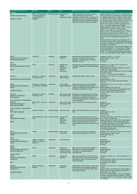
Instrument & agency (& any<br />
partners)<br />
FCI<br />
Flexible Combined Imager<br />
EUMETSAT (ESA)<br />
Missions Status Type Measurements & applications Technical characteristics<br />
MTG-I1 (imaging), MTG-<br />
I2 (imaging), MTG-I3<br />
(imaging), MTG-I4<br />
(imaging)<br />
Being developed Imaging multispectral<br />
height, precipitation, cloud motion,<br />
Measurements of cloud cover, cloud top<br />
radiometers (vis/IR) vegetation, radiation fluxes, convection, air<br />
mass analysis, cirrus cloud discrimination,<br />
tropopause monitoring, stability monitoring,<br />
total ozone and sea surface temparature<br />
Waveband: VIS0.4=0.414-0.474 µm, VIS0.5=0.49-<br />
0.53 µm, VIS0.6=0.615-0.665 µm, VIS0.8=0.84-0.89<br />
µm, VIS0.9=0.904-0.924 µm, NIR1.3=1.365-1.395<br />
µm, NIR1.6=1.585-1.635 µm, NIR2.2=2.225-2.275<br />
µm, IR3.8=3.6-4 µm, WV6.3=5.8-6.8 µm, WV7.3=7.1-<br />
7.6 µm, IR8.7=8.5-8.9 µm, IR9.7=9.51-9.81 µm,<br />
IR10.5=10.15-10.85 µm, IR12.3=12.05-12.55 µm,<br />
IR13.3=13-13.6 µm (measured at FWHM)<br />
Spatial resolution: VIS0.4=1.0 km, VIS0.5=1.0 km,<br />
VIS0.6=1.0 km, & 0.5 km, VIS0.8=1.0 km,<br />
VIS0.9=1.0 km, NIR1.3=1.0 km, NIR1.6=1.0 km,<br />
NIR2.2=1.0 km, & 0.5 km, IR3.8=2.0 km, & 1.0 km,<br />
WV6.3=2.0 km, WV7.3=2.0 km, IR8.7=2.0 km,<br />
IR9.7=2.0 km, IR10.5=2.0 km, & 1.0 km, IR12.3=2.0<br />
km, IR13.3=2.0 km (spatial sampling distance at<br />
SSP)<br />
Swath width: 200 km swath moved alternatlly W-E<br />
and E-W, moving up S-N a swath width at <strong>the</strong> end of<br />
each swath. Full Disc Coverage (FDC) or Local Area<br />
Coverage (LAC) possible.<br />
Accuracy: Cloud cover: 10%, Cloud top height: 1 km,<br />
Cloud top temparature: 1 K, Cloud type: 8 classes,<br />
Surface temparature: 0.7-2.0K, Specific humidity<br />
profile: 10%, Wind profile (horizontal component): 2 -<br />
10 m/s, Long wave Earth surface radiation: 5 W/m2<br />
GEMS<br />
Geostationary Environmental<br />
Monitoring Spectrometer<br />
KARI<br />
GeoSTAR<br />
MW Array Spectrometer (PATH)<br />
NASA<br />
Geoton-L1<br />
ROSKOSMOS (ROSHYDROMET)<br />
GERB<br />
Geostationary Earth Radiation<br />
Budget<br />
EUMETSAT (ESA)<br />
GGAK-E<br />
Module for Geophysical<br />
Measurements<br />
ROSHYDROMET (ROSKOSMOS)<br />
GGAK-M<br />
Module for Geophysical<br />
Measurements (SEM)<br />
ROSHYDROMET (ROSKOSMOS)<br />
GLM<br />
GEO Lightning Mapper<br />
NOAA<br />
GMI<br />
GPM Microwave Imager<br />
NASA<br />
GOCI<br />
Geostationary Ocean Colour<br />
Imager<br />
KARI<br />
GOES Comms<br />
Communications package on<br />
GOES<br />
NOAA<br />
GOLPE<br />
GPS Occultation and Passive<br />
reflection Experiment<br />
NASA (CONAE)<br />
GOME<br />
Global Ozone Monitoring<br />
Experiment<br />
ESA<br />
GOME-2<br />
Global Ozone Monitoring<br />
Experiment - 2<br />
EUMETSAT (ESA)<br />
COMS-2B Proposed Atmospheric<br />
chemistry<br />
PATH Proposed Imaging multispectral<br />
radiometers<br />
(passive<br />
microwave)<br />
Resurs DK 1, Resurs P<br />
N1, Resurs P N2<br />
Operational<br />
Meteosat-10, Meteosat- Operational<br />
11, Meteosat-8, Meteosat-<br />
9<br />
Elektro-L N1, Elektro-L<br />
N2, Elektro-L N3<br />
Meteor-M N1, Meteor-M<br />
N2<br />
Prototype<br />
Operational<br />
High resolution<br />
optical imagers<br />
Measurements of atmospheric chemistry,<br />
precursors of aerosols and ozone in<br />
particular, in high temporal and spatial<br />
resolution over Asia<br />
High frequency, all-wea<strong>the</strong>r temperature and<br />
humidity soundings for wea<strong>the</strong>r forecasting<br />
and SST<br />
Multispectral images of land surfaces<br />
Earth radiation Measures long and short wave radiation<br />
budget radiometers emitted and reflected from <strong>the</strong> Earth's<br />
surface, clouds and top of atmosphere. Full<br />
Earth disk, all channels in 5 mins<br />
Space environment<br />
and magnetic field<br />
Space environment<br />
and magnetic field<br />
Monitoring and forecasting of solar activity,<br />
of radiation and magnetic field in <strong>the</strong> near-<br />
Earth space, monitoring of natural and<br />
modified magnetosophere, ionosphere and<br />
upper atmosphere<br />
Space Environmental Monitoring (SEM)<br />
GOES-R, GOES-S Being developed Lightning imager Detect total lightning flash rate over near full<br />
disk<br />
GPM Constellation, GPM<br />
Core<br />
COMS<br />
GOES-11, GOES-12,<br />
GOES-13, GOES-14,<br />
GOES-15<br />
Being developed Imaging multispectral<br />
radiometers<br />
(passive<br />
microwave)<br />
Being developed Ocean colour<br />
instruments<br />
Waveband: UV/VIS : 0.3 - 0.5 µm<br />
Spatial resolution: 5km x 15km<br />
Swath width:<br />
Accuracy:<br />
Waveband: 50 - 57 GHz, 165 - 183 GHz, and<br />
possibly 118 - 125 GHz<br />
Spatial resolution: Temporal resolution is 15 to 30<br />
minutes; 25 - 50 km at nadir<br />
Swath width: Temporal resolution is 15 to 30 minutes;<br />
25 - 50 km at nadir<br />
Accuracy:


