

the earth observation handbook
The Earth Observation Handbook - Key Tables - SEOCA
The Earth Observation Handbook - Key Tables - SEOCA
- No tags were found...

You also want an ePaper? Increase the reach of your titles
YUMPU automatically turns print PDFs into web optimized ePapers that Google loves.
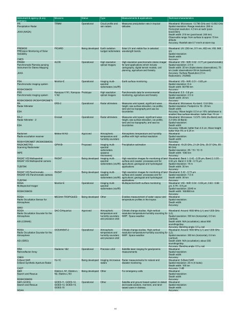
Instrument & agency (& any<br />
partners)<br />
PR<br />
Precipitation Radar<br />
JAXA (NASA)<br />
PREMOS<br />
PREcision Monitoring of Solar<br />
Variability<br />
CNES<br />
PRISM<br />
Panchromatic Remote-sensing<br />
Instrument for Stereo Mapping<br />
JAXA<br />
Missions Status Type Measurements & applications Technical characteristics<br />
TRMM Operational Cloud profile and<br />
rain radars<br />
PICARD<br />
Measures precipitation rate in tropical<br />
latitudes<br />
Being developed Earth radiation Solar UV and visible flux in selected<br />
budget radiometers wavelength bands.<br />
ALOS Operational High resolution<br />
optical imagers<br />
High resolution panchromatic stereo imager<br />
for land applications which include<br />
cartography, digital terrain models, civil<br />
planning, agriculture and forestry<br />
Waveband: Microwave: 13.796 GHz and 13.802 GHz<br />
Spatial resolution: Range resolution: 250 m<br />
Horizontal resolution: 4.3 km at nadir (postboost:5km)<br />
Swath width: 215 km (post-boost: 245 km)<br />
Observable range: from surface to approx 15 km<br />
altitude<br />
Accuracy: Rainfall rate 0.7 mm/h at storm top<br />
Waveband: UV: 230 nm, 311 nm, 402 nm; VIS: 548<br />
nm<br />
Spatial resolution:<br />
Swath width:<br />
Accuracy:<br />
Waveband: VIS - NIR: 0.52 - 0.77 µm (panchromatic)<br />
Spatial resolution: 2.5 m<br />
Swath width: 35 km (triplet stereo <strong>observation</strong>s), 70<br />
km (nadir <strong>observation</strong>s+35 km backward)<br />
Accuracy: Surface Resolution:2.5 m<br />
Radiometric: 3%RMS<br />
PSA<br />
Panchromatic imaging system<br />
ROSKOSMOS<br />
PSS<br />
Panchromatic imaging system<br />
ROSKOSMOS (ROSHYDROMET)<br />
RA<br />
Radar Altimeter<br />
ESA<br />
RA-2<br />
Radar Altimeter - 2<br />
ESA<br />
Radiomet<br />
Radio-occultation receiver<br />
ROSHYDROMET (ROSKOSMOS)<br />
RADIOMETRO<br />
Scanning Radiometer<br />
INPE<br />
RASAT VIS Multispectral<br />
RASAT VIS Multispectral camera<br />
TUBITAK<br />
RASAT VIS Panchromatic<br />
RASAR VIS Panchromatic camera<br />
TUBITAK<br />
RDSA<br />
Multispectral Imager<br />
ROSKOSMOS<br />
ROSA<br />
Radio Occultation Sensor for<br />
Atmosphere<br />
ISRO<br />
ROSA<br />
Radio Occultation Sounder for <strong>the</strong><br />
Atmosphere<br />
ASI (CONAE)<br />
ROSA<br />
Radio Occultation Sounder for <strong>the</strong><br />
Atmosphere<br />
ASI (ISRO)<br />
RRA<br />
Retroreflector Array<br />
Monitor-E Operational Imaging multispectral<br />
radiometers (vis/IR)<br />
Kanopus-V N1, Kanopus- Prototype<br />
V N2<br />
High resolution<br />
optical imagers<br />
Earth surface monitoring Waveband: VIS - NIR: 0.51 - 0.85 µm<br />
Spatial resolution: 8 m<br />
Swath width: 90/780 km<br />
Accuracy:<br />
Panchromatic data for environmental<br />
monitoring, agriculture and forestry<br />
ERS-2 Operational Radar altimeters Measures wind speed, significant wave<br />
height, sea surface elevation, ice profile,<br />
land and ice topography,and sea ice<br />
boundaries<br />
Envisat Operational Radar altimeters Measures wind speed, significant wave<br />
height, sea surface elevation, ice profile,<br />
land and ice topography, and sea ice<br />
boundaries<br />
Meteor-M N3 Approved Atmospheric<br />
temperature and<br />
humidity sounders<br />
GPM-Br Proposed Imaging multispectral<br />
radiometers<br />
(passive<br />
microwave)<br />
RASAT<br />
RASAT<br />
CNES<br />
S-Band SAR<br />
HJ-1C<br />
S-Band Syn<strong>the</strong>tic Aperture Radar<br />
CAST<br />
S&R<br />
Search and Rescue<br />
ROSKOSMOS<br />
S&R (GOES)<br />
Search and Rescue<br />
NOAA<br />
Being developed Imaging multispectral<br />
radiometers (vis/IR)<br />
Being developed Imaging multispectral<br />
radiometers (vis/IR)<br />
Monitor-E Operational Imaging multispectral<br />
radiometers (vis/IR)<br />
Atmospheric temperature and humidity<br />
profiles with high vertical resolution<br />
Waveband: 0.5 - 0.8 µm<br />
Spatial resolution: 2.5 m<br />
Swath width: 20 km<br />
Accuracy:<br />
Waveband: Microwave: Ku-band: 13.8 GHz<br />
Spatial resolution: Footprint is 16 - 20 km<br />
Swath width:<br />
Accuracy: Wave height: 0.5 m or 10% (whichever is<br />
smaller) Sea surface elevation: better than 10 cm<br />
Waveband: Microwave: 13.575 GHz (Ku-Band) and<br />
3.2 GHz (S-Band)<br />
Spatial resolution:<br />
Swath width:<br />
Accuracy: Altitude: better than 4.5 cm, Wave height:<br />
better than 5% or 0.25 m<br />
Waveband:<br />
Spatial resolution:<br />
Swath width:<br />
Accuracy:<br />
Precipitation estimation Waveband: 18-20 GHz, 21-24 GHz, 35-37 GHz, 85-<br />
89 GHz<br />
Spatial resolution: 26 / 15 / 10 / 6<br />
Swath width: 1000 km<br />
Accuracy:<br />
High resolution images for monitoring of land<br />
surface and coastal processes and for<br />
agricultural, geological and hydrological<br />
applications<br />
High resolution images for monitoring of land<br />
surface and coastal processes and for<br />
agricultural, geological and hydrological<br />
applications<br />
MEGHA-TROPIQUES Being developed O<strong>the</strong>r Enables measurement of water vapour and<br />
temperature profiles in <strong>the</strong> tropics<br />
SAC-D/Aquarius Approved Atmospheric<br />
temperature and<br />
humidity sounders<br />
and precision orbit<br />
OCEANSAT-2 Operational Atmospheric<br />
temperature and<br />
humidity sounders<br />
and precision orbit<br />
Waveband: Band 1: 0.42 - 0.55 µm, Band 2: 0.55 -<br />
0.63 µm, Band 3: 0.58 - 0.73 µm<br />
Spatial resolution: 15 m<br />
Swath width: 30 km<br />
Accuracy:<br />
Waveband: 0.42 - 0.73 µm<br />
Spatial resolution: 7.5 m<br />
Swath width: 30 km<br />
Accuracy:<br />
Multispectral Earth surface monitoring Waveband: VIS - NIR: 0.54 - 0.59 µm, 0.63 - 0.68<br />
µm, 0.79 - 0.9 µm<br />
Spatial resolution: 20/40 m<br />
Swath width: 160/890 km<br />
Accuracy:<br />
Climate change studies. High-vertical<br />
resolution temperature-humidity sounding for<br />
NWP. Space wea<strong>the</strong>r<br />
Climate change studies. High-vertical<br />
resolution temperature-humidity sounding for<br />
NWP. Space wea<strong>the</strong>r<br />
Diademe 1&2 Operational Precision orbit Satellite laser ranging for geodynamic<br />
measurements<br />
Elektro-L N1, Elektro-L<br />
N2, Elektro-L N3<br />
GOES-11, GOES-12,<br />
GOES-13, GOES-14,<br />
GOES-15<br />
Being developed Imaging microwave<br />
radars<br />
Radar measurements for natural and<br />
disaster monitoring<br />
Waveband:<br />
Spatial resolution:<br />
Swath width:<br />
Accuracy:<br />
Waveband: Around 1600 MHz (L1) and 1200 GHz<br />
(L2).<br />
Spatial resolution: 300 km (horizontal), 0.5 km<br />
(vertical).<br />
Swath width: N/A (occultation); about 650<br />
soundings/day.<br />
Accuracy: Bending angle: 0.5 µ rad<br />
Waveband: Around 1600 MHz (L1) and 1200 GHz<br />
(L2).<br />
Spatial resolution: 300 km (horizontal), 0.5 km<br />
(vertical).<br />
Swath width: N/A (occultation); about 300<br />
soundings/day.<br />
Accuracy: Bending angle: 0.5 µ rad<br />
Waveband:<br />
Spatial resolution:<br />
Swath width:<br />
Accuracy:<br />
Waveband: S-Band SAR<br />
Spatial resolution: 20 m (4 looks)<br />
Swath width: 100 km<br />
Accuracy: 3 dB<br />
Being developed O<strong>the</strong>r For emergency calls Waveband:<br />
Spatial resolution:<br />
Swath width:<br />
Accuracy:<br />
Operational O<strong>the</strong>r Satellite and ground based system to detect<br />
and locate aviators, mariners, and landbased<br />
users in distress.<br />
Waveband:<br />
Spatial resolution:<br />
Swath width:<br />
Accuracy:<br />
44


