

the earth observation handbook
The Earth Observation Handbook - Key Tables - SEOCA
The Earth Observation Handbook - Key Tables - SEOCA
- No tags were found...

You also want an ePaper? Increase the reach of your titles
YUMPU automatically turns print PDFs into web optimized ePapers that Google loves.
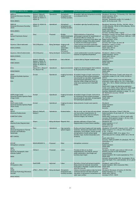
Instrument & agency (& any<br />
partners)<br />
AMSU-A<br />
Advanced Microwave Sounding<br />
Unit-A<br />
NOAA (BNSC)<br />
Missions Status Type Measurements & applications Technical characteristics<br />
Metop-A, Metop-B,<br />
Metop-C, NOAA-15,<br />
NOAA-16, NOAA-17,<br />
NOAA-18<br />
Operational<br />
Atmospheric<br />
temperature and<br />
humidity sounders<br />
All-wea<strong>the</strong>r night-day temperature sounding<br />
to an altitude of 45 km<br />
Waveband: Microwave: 15 channels, 23.8 - 89.0 GHz<br />
Spatial resolution: 48 km<br />
Swath width: 2054 km<br />
Accuracy: Temperature profile: 2 K, humidity: 3<br />
kg/m2, ice & snow cover: 10%<br />
AMSU-B<br />
Advanced Microwave Sounding<br />
Unit-B<br />
NOAA (BNSC)<br />
APS<br />
Aerosol Polarimetry Sensor<br />
NASA<br />
Aquarius L-Band radiometer<br />
NASA (CONAE)<br />
Aquarius L-Band Scatterometer<br />
NASA (CONAE)<br />
ARGOS<br />
CNES (NASA)<br />
Arina<br />
ROSKOSMOS<br />
ASAR<br />
Advanced Syn<strong>the</strong>tic-Aperture<br />
Radar<br />
ESA<br />
ASAR (image mode)<br />
Advanced Syntetic Aperture Radar<br />
(Image mode)<br />
ESA<br />
ASAR (wave mode)<br />
Advanced Syntetic Aperture Radar<br />
(Wave mode)<br />
ESA<br />
ASCAT<br />
Advanced Scatterometer<br />
EUMETSAT (ESA)<br />
ASM<br />
Absolute Scalar Magnetometer<br />
CNES<br />
ASTER<br />
Advanced Spaceborne Thermal<br />
Emission and Reflection<br />
Radiometer<br />
METI (NASA)<br />
ATCOR<br />
Atmospheric correction<br />
ISRO<br />
ATLAS<br />
Advanced Topographic Laser<br />
Altimeter System<br />
NASA<br />
ATLID<br />
ATmospheric LIDar<br />
NOAA-15, NOAA-16,<br />
NOAA-17<br />
Operational<br />
Atmospheric<br />
temperature and<br />
humidity sounders<br />
Glory Proposed Multiple<br />
direction/polarisatio<br />
n radiometers<br />
SAC-D/Aquarius<br />
Being developed Imaging multispectral<br />
radiometers<br />
(passive<br />
microwave)<br />
All-wea<strong>the</strong>r night-day humidity sounding Waveband: Microwave: 89 GHz, 150 GHz, 183.3±<br />
1.0 GHz (2bands), 183.3± 3.0 GHz (2bands), 183.3±<br />
7.0 GHz (2bands)<br />
Spatial resolution: 16 km<br />
Swath width: 2200 km<br />
Accuracy: Humidity profile: 1 kg/m2,<br />
Global distribution of natural and<br />
anthropogenic aerosols for quantification of<br />
<strong>the</strong> aerosol effect on climate, <strong>the</strong><br />
anthropogenic component of this effect, and<br />
<strong>the</strong> long-term change of this effect caused<br />
by natural and anthropogenic factors<br />
L-band passive microwave radiometer<br />
measures brightness temperature of ocean<br />
to retrieve salinity<br />
SAC-D/Aquarius Being developed Scatterometers L-band scatterometer to provide roughness<br />
corection to brightness temperature<br />
Metop-A, Metop-B,<br />
Metop-C, NOAA-15,<br />
NOAA-16, NOAA-17,<br />
NOAA-18, NOAA-19,<br />
SARAL<br />
Resurs DK 1, Resurs P<br />
N1, Resurs P N2<br />
Waveband: 9 bands: VIS and SWIR: 0.412 µm, 0.488<br />
µm, 0.555 µm, 0.672 µm, 0.910 µm, 0.865 µm, 1.378<br />
µm, 1.610 µm, 2.250 µm<br />
Spatial resolution: 10 km<br />
Swath width: 10 km<br />
Accuracy: AOT Ocean .02, land .04<br />
Waveband: L-band (1.4 GHz)<br />
Spatial resolution: 100 km<br />
Swath width: 300 km<br />
Accuracy: 0.2 psu<br />
Waveband: L-Band (1.2 GHz)<br />
Spatial resolution: 100 km<br />
Swath width: 300 km<br />
Accuracy: 0.2 psu<br />
Operational Data collection Location data by Doppler measurements Waveband:<br />
Spatial resolution:<br />
Swath width:<br />
Accuracy:<br />
Operational<br />
Envisat Operational Imaging microwave<br />
radars<br />
Envisat Operational Imaging microwave<br />
radars<br />
Envisat Operational Imaging microwave<br />
radars<br />
Metop-A, Metop-B,<br />
Metop-C<br />
ESA<br />
ATMS<br />
JPSS-1, JPSS-2, NPP<br />
Advanced Technology Microwave<br />
Sounder<br />
NASA (NOAA)<br />
Space environment Insights into electromagnetic field variations<br />
as <strong>the</strong> precursors of Earth quakes<br />
All-wea<strong>the</strong>r images of ocean, land and ice<br />
for monitoring of land surface processes,<br />
sea and polar ice, sea state, and geological<br />
and hydrological applications. Has 2<br />
stripmap modes (Image and Wave (for<br />
ocean wave spectra)) and 3 ScanSAR<br />
modes<br />
All-wea<strong>the</strong>r images of ocean, land and ice<br />
for monitoring of land surface processes,<br />
sea and polar ice, sea state, and geological<br />
and hydrological applications<br />
Measurements of ocean wave spectra<br />
Operational Scatterometers Sea ice cover, sea ice type and wind speed<br />
over sea surface measurements. Air<br />
pressure over ocean, polar ice contours,<br />
ice/snow imagery, soil moisture.<br />
Swarm Being developed Magnetic field Absolute calibration of Vector Field<br />
Magnetometer on board Swarm satellites<br />
Terra Operational High resolution<br />
optical imagers<br />
Surface and cloud imaging with high spatial<br />
resolution, stereoscopic <strong>observation</strong> of local<br />
topography, cloud heights, volcanic plumes,<br />
and generation of local surface digital<br />
elevation maps. Surface temperature and<br />
emissivity<br />
Waveband:<br />
Spatial resolution:<br />
Swath width:<br />
Accuracy:<br />
Waveband: Microwave: C-band, with choice of 5<br />
polarisation modes (VV, HH, VV/HH, HV/HH, or<br />
VH/VV)<br />
Spatial resolution: Image, wave and alternating<br />
polarisation modes: approx 30 x 30 m, Wide swath<br />
mode: 150 x 150 m, Global monitoring mode: 950 m<br />
x 950 m<br />
Swath width: Image and alternating polarisation<br />
modes: up to 100 km, Wave mode: 5 km, Wide swath<br />
and global monitoring modes: 400 km or more<br />
Accuracy: Radiometric resolution in range: 1.5 - 3.5<br />
dB, Radiometric accuracy: 0.65 dB<br />
Waveband:<br />
Spatial resolution:<br />
Swath width:<br />
Accuracy:<br />
Waveband:<br />
Spatial resolution:<br />
Swath width:<br />
Accuracy:<br />
RESOURCESAT-3 Proposed O<strong>the</strong>r Atmospheric correction Waveband:<br />
Spatial resolution:<br />
Swath width:<br />
Accuracy:<br />
ICESat-II Proposed Lidars Provision of data on ice sheet<br />
height/thickness, land altitude, aerosol<br />
height distributions, cloud height and<br />
boundary layer height<br />
EarthCARE Approved Lidars Derivation of cloud and aerosol properties -<br />
Measurement of molecular and particle<br />
backscatter in Rayleigh, co-polar and crosspolar<br />
Mie channels<br />
Being developed Atmospheric<br />
temperature and<br />
humidity sounders<br />
Collects microwave radiance data that when<br />
combined with <strong>the</strong> CrIS data will permit<br />
calculation of atmospheric temperature and<br />
water vapor profiles.<br />
Waveband: Microwave: C Band, 5.256 GHz<br />
Spatial resolution: Hi-res mode: 25 - 37 km, Nominal<br />
mode: 50 km<br />
Swath width: Continuous; 2 x 500 km swath width<br />
Accuracy: Wind speeds in range 4 - 24 m/s: 2 m/s<br />
and direction accuracy of 20 deg<br />
Waveband: N/A<br />
Spatial resolution: 0.1 nT<br />
Swath width: N/A<br />
Accuracy: 0.1 nT<br />
Waveband: VIS and NIR: 3 bands in 0.52 - 0.86 µm,<br />
SWIR: 6 bands in 1.6 - 2.43 µm, TIR: 5 bands in<br />
8.125 - 11.65 µm<br />
Spatial resolution: VNIR: 15 m, stereo: 15 m<br />
horizontally and 25 m vertical, SWIR: 30 m, TIR: 90<br />
m<br />
Swath width: 60 km<br />
Accuracy: VNIR and SWIR: 4% (absolute), TIR: 4 K,<br />
Geolocation: 7 m<br />
Waveband: VIS-NIR: Laser emits at 1064 nm (for<br />
altimetry) and 532 nm (for atmospheric<br />
measurements)<br />
Spatial resolution: 66 m spots separated by 170 m<br />
Swath width:<br />
Accuracy: Aerosol profile: 20%, Ice elevation: 20 cm,<br />
Cloud top height: 75 m, Land elevation: 20 cm, geoid:<br />
5 m<br />
Waveband: Laser at 355 nm<br />
Spatial resolution: 300 m horizontal (TBC)<br />
Swath width:<br />
Accuracy:<br />
Waveband: Microwave: 22 bands, 23-184 GHz<br />
Spatial resolution: 5.2 - 1.1 deg<br />
Swath width: 2300 km<br />
Accuracy: 0.75 K - 3.60 K<br />
29


