

the earth observation handbook
The Earth Observation Handbook - Key Tables - SEOCA
The Earth Observation Handbook - Key Tables - SEOCA
- No tags were found...

Create successful ePaper yourself
Turn your PDF publications into a flip-book with our unique Google optimized e-Paper software.
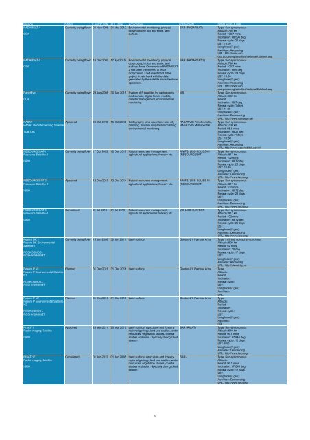
Mission Status Launch Date EOL Date Applications Instruments Orbit Details & URL<br />
RADARSAT-1<br />
CSA<br />
Currently being flown 04 Nov 1995 31 Mar 2012 Environmental monitoring, physical<br />
oceanography, ice and snow, land<br />
surface<br />
SAR (RADARSAT)<br />
Type: Sun-synchronous<br />
Altitude: 798 km<br />
Period: 100.7 mins<br />
Inclination: 98.594 deg<br />
Repeat cycle: 24 days<br />
LST: 18:00<br />
Longitude (if geo):<br />
Asc/desc: Ascending<br />
URL: http://www.asccsa.gc.ca/eng/satellites/radarsat1/default.asp<br />
RADARSAT-2<br />
CSA<br />
RapidEye<br />
DLR<br />
RASAT<br />
RASAT Remote Sensing Satellite<br />
TUBITAK<br />
RESOURCESAT-1<br />
Resource Satellite-1<br />
ISRO<br />
RESOURCESAT-2<br />
Resource Satellite-2<br />
ISRO<br />
RESOURCESAT-3<br />
Resource Satellite-3<br />
ISRO<br />
Resurs DK 1<br />
Resurs DK Environmental<br />
Satellite 1<br />
ROSKOSMOS /<br />
ROSHYDROMET<br />
Resurs P N1<br />
Resurs P Environmental Satellite<br />
N1<br />
ROSKOSMOS /<br />
ROSHYDROMET<br />
Resurs P N2<br />
Resurs P Environmental Satellite<br />
N2<br />
ROSKOSMOS /<br />
ROSHYDROMET<br />
RISAT-1<br />
Radar Imaging Satellite<br />
ISRO<br />
RISAT-1F<br />
Radar Imaging Satellite<br />
ISRO<br />
Currently being flown 14 Dec 2007 17 Apr 2015 Environmental monitoring, physical<br />
oceanography, ice and snow, land<br />
surface. Note: Ownership of RADARSAT-<br />
2 has been transferred to MDA<br />
Corporation. CSA investment in <strong>the</strong><br />
project is paid back with <strong>the</strong> data<br />
generated by <strong>the</strong> satellite since it entered<br />
operations.<br />
SAR (RADARSAT-2)<br />
Currently being flown 29 Aug 2008 30 Aug 2015 System of 5 satellites for cartography,<br />
land surface, digital terrain models,<br />
disaster management, environmental<br />
monitoring.<br />
Approved 30 Oct 2010 15 Oct 2013 Cartography, land cover/land use, city<br />
planning, disaster mitigation/monitoring,<br />
environmental monitoring.<br />
Currently being flown 17 Oct 2003 10 Dec 2010 Natural resources management;<br />
agricultural applications; forestry etc.<br />
Approved 12 Dec 2010 12 Dec 2014 Natural resources management;<br />
agricultural applications; forestry etc.<br />
Considered 01 Jul 2014 01 Jul 2019 Natural resources management;<br />
agricultural applications; forestry etc.<br />
MSI<br />
RASAT VIS Panchromatic,<br />
RASAT VIS Multispectral<br />
AWiFS, LISS-IV, LISS-III<br />
(RESOURCESAT)<br />
AWiFS, LISS-IV, LISS-III<br />
(RESOURCESAT)<br />
WS LISS III, ATCOR<br />
Type: Sun-synchronous<br />
Altitude: 798 km<br />
Period: 100.7 mins<br />
Inclination: 98.6 deg<br />
Repeat cycle: 24 days<br />
LST: 18:00<br />
Longitude (if geo):<br />
Asc/desc: Ascending<br />
URL: http://www.asccsa.gc.ca/eng/satellites/radarsat2/default.asp<br />
Type: Sun-synchronous<br />
Altitude: 622 km<br />
Period:<br />
Inclination: 98.7 deg<br />
Repeat cycle: 1 days<br />
LST: 11:00<br />
Longitude (if geo):<br />
Asc/desc: Descending<br />
URL: http://www.rapideye.de/<br />
Type: Sun-synchronous<br />
Altitude: 700 km<br />
Period: 98.8 mins<br />
Inclination: 98.21 deg<br />
Repeat cycle: 4 days<br />
LST: 10:30<br />
Longitude (if geo):<br />
Asc/desc: Ascending<br />
URL: http://www.uzay.tubitak.gov.tr/<br />
Type: Sun-synchronous<br />
Altitude: 817 km<br />
Period: 102 mins<br />
Inclination: 98.72 deg<br />
Repeat cycle: 26 days<br />
LST: 10:30<br />
Longitude (if geo):<br />
Asc/desc: Descending<br />
URL: http://www.isro.org/<br />
Type: Sun-synchronous<br />
Altitude: 817 km<br />
Period: 102 mins<br />
Inclination: 98.72 deg<br />
Repeat cycle: 26 days<br />
LST:<br />
Longitude (if geo):<br />
Asc/desc: Descending<br />
URL: http://www.isro.org/<br />
Type: Sun-synchronous<br />
Altitude: 817 km<br />
Period: 102 mins<br />
Inclination: 98.72 deg<br />
Repeat cycle: 26 days<br />
LST:<br />
Longitude (if geo):<br />
Asc/desc: Descending<br />
URL: http://www.isro.org/<br />
Currently being flown 15 Jun 2006 30 Jun 2011 Land surface Geoton-L1, Pamela, Arina Type: Inclined, non-sunsynchronous<br />
Altitude: 600 km<br />
Period: 92 mins<br />
Inclination: 70 deg<br />
Repeat cycle: 17 days<br />
LST:<br />
Longitude (if geo):<br />
Asc/desc: Ascending<br />
URL: http://planet.iitp.ru<br />
Planned 31 Dec 2011 31 Dec 2016 Land surface Geoton-L1, Pamela, Arina Type:<br />
Altitude:<br />
Period:<br />
Inclination:<br />
Repeat cycle:<br />
LST:<br />
Longitude (if geo):<br />
Asc/desc:<br />
URL:<br />
Planned 31 Dec 2013 31 Dec 2018 Land surface Geoton-L1, Pamela, Arina Type:<br />
Altitude:<br />
Period:<br />
Inclination:<br />
Repeat cycle:<br />
LST:<br />
Longitude (if geo):<br />
Asc/desc:<br />
URL:<br />
Approved 25 Mar 2011 25 Mar 2015 Land surface, agriculture and forestry,<br />
regional geology, land use studies, water<br />
resources, vegetation studies, coastal<br />
studies and soils - Specially during cloud<br />
season<br />
SAR (RISAT)<br />
Considered 01 Jan 2012 01 Jan 2018 Land surface, agriculture and forestry,<br />
regional geology, land use studies, water<br />
resources, vegetation studies, coastal<br />
studies and soils - Specially during cloud<br />
season<br />
SAR-L<br />
Type: Sun-synchronous<br />
Altitude: 610 km<br />
Period: 96.5 mins<br />
Inclination: 97.844 deg<br />
Repeat cycle: 12 days<br />
LST: 6:00<br />
Longitude (if geo):<br />
Asc/desc: Descending<br />
URL: http://www.isro.org/<br />
Type: Sun-synchronous<br />
Altitude:<br />
Period: 96.5 mins<br />
Inclination: 97.844 deg<br />
Repeat cycle: 12 days<br />
LST:<br />
Longitude (if geo):<br />
Asc/desc: Descending<br />
URL: http://www.isro.org/<br />
20


