

the earth observation handbook
The Earth Observation Handbook - Key Tables - SEOCA
The Earth Observation Handbook - Key Tables - SEOCA
- No tags were found...

You also want an ePaper? Increase the reach of your titles
YUMPU automatically turns print PDFs into web optimized ePapers that Google loves.
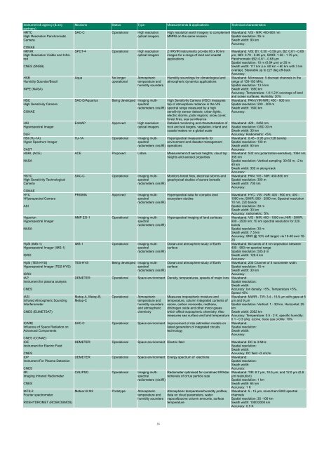
Instrument & agency (& any<br />
partners)<br />
HRTC<br />
High Resolution Panchromatic<br />
Camera<br />
CONAE<br />
HRVIR<br />
High Resolution Visible and Infrared<br />
CNES (SNSB)<br />
HSB<br />
Humidity Sounder/Brazil<br />
INPE (NASA)<br />
HSC<br />
High Sensitivity Camera<br />
CONAE<br />
HSI<br />
Hyperspectral Imager<br />
DLR<br />
HSI (HJ-1A)<br />
Hyper Spectrum Imager<br />
CAST<br />
HSRL (ACE)<br />
NASA<br />
HSTC<br />
High Sensitivity Technological<br />
Camera<br />
CONAE<br />
HYC<br />
HYperspectral Camera<br />
ASI<br />
Hyperion<br />
Hyperspectral Imager<br />
NASA<br />
HySI (IMS-1)<br />
Hyperspectral Imager (IMS-1)<br />
ISRO<br />
HySI (TES-HYS)<br />
Hyperspectral Imager (TES-HYS)<br />
ISRO<br />
IAP<br />
Instrument for plasma analysis<br />
CNES<br />
IASI<br />
Infrared Atmospheric Sounding<br />
Interferometer<br />
CNES (EUMETSAT)<br />
ICARE<br />
Influence of Space Radiation on<br />
Advanced Components<br />
CNES (CONAE)<br />
ICE<br />
Instrument for Electric Field<br />
CNES<br />
IDP<br />
Instrument For Plasma Detection<br />
CNES<br />
IIR<br />
Imaging Infrared Radiometer<br />
CNES<br />
IKFS-2<br />
Fourier spectrometer<br />
ROSHYDROMET (ROSKOSMOS)<br />
Missions Status Type Measurements & applications Technical characteristics<br />
SAC-C Operational High resolution<br />
optical imagers<br />
SPOT-4 Operational High resolution<br />
optical imagers<br />
Aqua<br />
SAC-D/Aquarius<br />
No longer<br />
operational<br />
Atmospheric<br />
temperature and<br />
humidity sounders<br />
High resolution <strong>earth</strong> imagery to complement Waveband: VIS - NIR: 400-900 nm<br />
MMRS on <strong>the</strong> same mission<br />
Spatial resolution: 35 m<br />
Swath width: 90 km<br />
Accuracy:<br />
2 HRVIR instruments provide 60 x 60 km<br />
images for a range of land and coastal<br />
applications<br />
Humidity soundings for climatological and<br />
atmospheric dynamics applications<br />
Being developed Imaging multispectral<br />
top of atmosphere radiance in <strong>the</strong> VIS<br />
High Sensitivity Camera (HSC) measures<br />
radiometers (vis/IR) spectral range measured by a high<br />
sensitivity sensor detects: urban lights,<br />
electric storms, polar regions, snow cover,<br />
forest fires, sea survilleance<br />
EnMAP Approved High resolution<br />
optical imagers<br />
Detailed monitoring and characterization of<br />
rock and soil targets, vegitation, inland and<br />
coastal waters on a global scale<br />
HJ-1A Operational Imaging multispectral<br />
Hyperspectral measurements for<br />
environment and disaster management<br />
radiometers (vis/IR) operations<br />
ACE Proposed Lidars Measurement of aerosol heights, cloud top<br />
heights and aerosol properties<br />
SAC-C Operational Imaging multispectral<br />
Monitors forest fires, electrical storms and<br />
geophysical studies of aurora borealis<br />
radiometers (vis/IR)<br />
PRISMA Approved Imaging multispectral<br />
Hyperspectral data for complex land<br />
ecosystem studies<br />
radiometers (vis/IR)<br />
NMP EO-1 Operational Imaging multispectral<br />
Hyperspectral imaging of land surfaces<br />
radiometers (vis/IR)<br />
IMS-1 Operational Imaging multispectral<br />
Ocean and atmosphere study of Earth<br />
surface<br />
radiometers (vis/IR)<br />
TES-HYS<br />
Being developed Imaging multispectral<br />
surface<br />
Ocean and atmosphere study of Earth<br />
radiometers (vis/IR)<br />
Waveband: VIS: B1: 0.50 - 0.59 µm, B2: 0.61 - 0.68<br />
µm, NIR: 0.79 - 0.89 µm, SWIR: 1.58 - 1.75 µm,<br />
Panchromatic:(B2) 0.61 - 0.68 µm<br />
Spatial resolution: 10 m (0.64 µm) or 20 m<br />
Swath width: 117 km (i.e. 60 km + 60 km with 3 km<br />
overlap). Steerable up to ±27 deg off-track<br />
Accuracy:<br />
Waveband: Microwave: 5 discreet channels in <strong>the</strong><br />
range of 150-183 MHz<br />
Spatial resolution: 13.5 km<br />
Swath width: 1650 km<br />
Accuracy: Temperature: 1.0-1.2 K coverage of land<br />
and ocean surfaces, Humidity: 20%<br />
Waveband: PAN (VIR-NIR): 450 - 900 nm<br />
Spatial resolution: 200 - 300 m<br />
Swath width: 1600 km<br />
Accuracy:<br />
Waveband: 420 - 2450 nm<br />
Spatial resolution: GSD 30 m<br />
Swath width: 30 km<br />
Accuracy: Radiometric:


