

the earth observation handbook
The Earth Observation Handbook - Key Tables - SEOCA
The Earth Observation Handbook - Key Tables - SEOCA
- No tags were found...

Create successful ePaper yourself
Turn your PDF publications into a flip-book with our unique Google optimized e-Paper software.
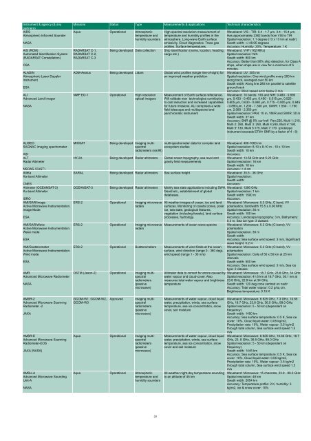
Instrument & agency (& any<br />
partners)<br />
AIRS<br />
Atmospheric Infra-red Sounder<br />
NASA<br />
AIS (RCM)<br />
Automated Identification System<br />
(RADARSAT Constellation)<br />
CSA<br />
ALADIN<br />
Atmospheric Laser Doppler<br />
Instrument<br />
ESA<br />
ALI<br />
Advanced Land Imager<br />
NASA<br />
Missions Status Type Measurements & applications Technical characteristics<br />
Aqua Operational Atmospheric<br />
temperature and<br />
humidity sounders<br />
RADARSAT C-1,<br />
RADARSAT C-2,<br />
RADARSAT C-3<br />
Being developed Data collection<br />
High spectral resolution measurement of<br />
temperature and humidity profiles in <strong>the</strong><br />
atmosphere. Long-wave Earth surface<br />
emissivity. Cloud diagnostics. Trace gas<br />
profiles. Surface temperatures.<br />
Ship identification (name, location, heading,<br />
cargo etc.)<br />
ADM-Aeolus Being developed Lidars Global wind profiles (single line-of-sight) for<br />
an improved wea<strong>the</strong>r prediction<br />
NMP EO-1 Operational High resolution<br />
optical imagers<br />
Measurement of Earth surface reflectance.<br />
Will validate new technologies contributing<br />
to cost reduction and increased capabilities<br />
for future missions. ALI comprises a wide<br />
field telescope and multispectral and<br />
panchromatic instrument<br />
Waveband: VIS - TIR: 0.4 - 1.7 µm, 3.4 - 15.4 µm,<br />
Has approximately 2382 bands from VIS to TIR<br />
Spatial resolution: 1.1 degree (13 x 13 km at nadir)<br />
Swath width: +/-48.95 degrees<br />
Accuracy: Humidity: 20%, Temperature: 1 K<br />
Waveband: VHF (162 MHz)<br />
Spatial resolution: N/A<br />
Swath width: 800 km<br />
Accuracy: Better than 90% ship detection, for Class A<br />
ships, when ships are in view for a minimum of 5<br />
minutes.<br />
Waveband: UV: 355 nm<br />
Spatial resolution: One wind profile every 200 km<br />
along track, averaged over 50 km<br />
Swath width: Along line 285 km parallel to satellite<br />
ground track<br />
Accuracy: Wind speed error below 2 m/s<br />
Waveband: 10 bands: VIS and NIR: 0.480 - 0.690<br />
µm, 0.433 - 0.453 µm, 0.450 - 0.515 µm, 0.525 -<br />
0.605 µm, 0.630 - 0.690 µm, 0.775 - 0.805 µm, 0.845<br />
- 0.890 µm, 1.200 - 1.300 µm, SWIR: 1.550 - 1.750<br />
µm, 2.080 - 2.350 µm<br />
Spatial resolution: PAN: 10 m, VNIR and SWIR: 30 m<br />
Swath width: 37 km<br />
Accuracy: SNR @ 5% surf refl Pan:220, Multi 1: 215,<br />
Multi 2: 280, Multi 3: 290, Multi 4:240, Multi 4':190,<br />
Multi 5':130, Multi 5:175, Multi 7:170 (prototype<br />
instrument exceeds ETM+ SNR by a factor of 4 - 8)<br />
ALISEO<br />
SAGNAC imaging spectrometer<br />
ASI<br />
ALT<br />
Radar Altimeter<br />
NSOAS (CAST)<br />
AltiKa<br />
Ka-band Altimeter<br />
CNES<br />
Altimeter (OCEANSAT-3)<br />
Ku-band Altimeter<br />
ISRO<br />
AMI/SAR/Image<br />
Active Microwave Instrumentation.<br />
Image Mode<br />
ESA<br />
AMI/SAR/Wave<br />
Active Microwave Instrumentation.<br />
Wave mode<br />
ESA<br />
AMI/Scatterometer<br />
Active Microwave Instrumentation.<br />
Wind mode<br />
ESA<br />
AMR<br />
Advanced Microwave Radiometer<br />
NASA<br />
MIOSAT<br />
Being developed Imaging multispectral<br />
ecosystem studies<br />
mutli-spectrometer data for complex land<br />
radiometers (vis/IR)<br />
HY-2A Being developed Radar altimeters Global ocean topography, sea level and<br />
gravity field measurements<br />
Waveband: 400-1000 nm<br />
Spatial resolution: 8-10 x 8-10 m - 10 x 10 km<br />
Swath width: 10 km<br />
Accuracy:<br />
Waveband: 13.58 GHz and 5.25 GHz<br />
Spatial resolution: 16 km<br />
Swath width: 16 km<br />
Accuracy: < 4 cm<br />
SARAL Being developed Radar altimeters Sea surface height Waveband: 35.5 - 36 GHz<br />
Spatial resolution:<br />
Swath width:<br />
Accuracy:<br />
OCEANSAT-3 Being developed Radar altimeters Mainly sea state applications including SWH, Waveband: 1306 GHz<br />
Geoid etc., establishment of global Spatial resolution: 1 km<br />
databases.<br />
Swath width: 1500 m<br />
ERS-2 Operational Imaging microwave<br />
radars<br />
ERS-2 Operational Imaging microwave<br />
radars<br />
All-wea<strong>the</strong>r images of ocean, ice and land<br />
surfaces. Monitoring of coastal zones, polar<br />
ice, sea state, geological features,<br />
vegetation (including forests), land surface<br />
processes, hydrology.<br />
Measurements of ocean wave spectra<br />
ERS-2 Operational Scatterometers Measurements of wind fields at <strong>the</strong> ocean<br />
surface, wind direction (range 0 - 360 deg),<br />
wind speed (range 1 - 30 m/s)<br />
OSTM (Jason-2) Operational Imaging multispectral<br />
radiometers<br />
(passive<br />
microwave)<br />
Altimeter data to correct for errors caused by<br />
water vapour and cloud-cover. Also<br />
measures total water vapour and brightness<br />
temperature<br />
Accuracy:<br />
Waveband: Microwave: 5.3 GHz, C band, VV<br />
polarisation, bandwidth 15.5 ± 0.06 MHz<br />
Spatial resolution: 30 m<br />
Swath width: 100 km<br />
Accuracy: Landscape topography: 3 m, Bathymetry:<br />
0.3 m, Sea ice type: 3 classes<br />
Waveband: Microwave: 5.3 GHz (C-band), VV<br />
polarisation<br />
Spatial resolution: 30 m<br />
Swath width:<br />
Accuracy: Sea surface wind speed: 3 m/s, Significant<br />
wave height: 0.2 m<br />
Waveband: Microwave: 5.3 GHz (C-band), VV<br />
polarisation<br />
Spatial resolution: Cells of 50 x 50 km at 25 km<br />
intervals<br />
Swath width: 500 km<br />
Accuracy: Sea surface wind speed: 3 m/s, Sea ice<br />
type: 2 classes<br />
Waveband: Microwave: 18.7 GHz, 23.8 GHz, 34 GHz<br />
Spatial resolution: 41.6 km at 18.7 GHz, 36.1 km at<br />
23.8 GHz, 22.9 km at 34 GHz<br />
Swath width: 120 deg cone centred on nadir<br />
Accuracy: Total water vapour: 0.2 g/sq cm,<br />
Brightness temperature: 0.15 K<br />
AMSR-2<br />
Advanced Microwave Scanning<br />
Radiometer -2<br />
JAXA<br />
AMSR-E<br />
Advanced Microwave Scanning<br />
Radiometer-EOS<br />
JAXA (NASA)<br />
AMSU-A<br />
Advanced Microwave Sounding<br />
Unit-A<br />
NASA<br />
GCOM-W1, GCOM-W2,<br />
GCOM-W3<br />
Approved<br />
Imaging multispectral<br />
radiometers<br />
(passive<br />
microwave)<br />
Aqua Operational Imaging multispectral<br />
radiometers<br />
(passive<br />
microwave)<br />
Aqua Operational Atmospheric<br />
temperature and<br />
humidity sounders<br />
Measurements of water vapour, cloud liquid<br />
water, precipitation, winds, sea surface<br />
temperature, sea ice concentration, snow<br />
cover, soil moisture<br />
Measurements of water vapour, cloud liquid<br />
water, precipitation, winds, sea surface<br />
temperature, sea ice concentration, snow<br />
cover and soil moisture<br />
All-wea<strong>the</strong>r night-day temperature sounding<br />
to an altitude of 45 km<br />
Waveband: Microwave: 6.925 GHz, 7.3 GHz, 10.65<br />
GHz, 18.7 GHz, 23.8 GHz, 36.5 GHz, 89.0 GHz<br />
Spatial resolution: 5 - 50 km (dependent on<br />
frequency)<br />
Swath width: 1450 km<br />
Accuracy: Sea surface temparature: 0.5 K, Sea ice<br />
cover: 10%, Cloud liquid water: 0.05 kg/m2,<br />
Precipitation rate: 10%, Water vapour: 3.5 kg/m2<br />
through total column, Sea surface wind speed 1.5<br />
m/s<br />
Waveband: Microwave: 6.925 GHz, 10.65 GHz, 18.7<br />
GHz, 23. 8 GHz, 36.5 GHz, 89.0 GHz<br />
Spatial resolution: 5 - 50 km (dependent on<br />
frequency)<br />
Swath width: 1445 km<br />
Accuracy: Sea surface temparature: 0.5 K, Sea ice<br />
cover: 10%, Cloud liquid water: 0.05 kg/m2,<br />
Precipitation rate: 10%, Water vapour: 3.5 kg/m2<br />
through total column, Sea surface wind speed 1.5<br />
m/s<br />
Waveband: Microwave: 15 channels, 23.8 - 89.0 GHz<br />
Spatial resolution: 48 km<br />
Swath width: 2054 km<br />
Accuracy: Temperature profile: 2 K, humidity: 3<br />
kg/m2, ice & snow cover: 10%<br />
28


