

the earth observation handbook
The Earth Observation Handbook - Key Tables - SEOCA
The Earth Observation Handbook - Key Tables - SEOCA
- No tags were found...

You also want an ePaper? Increase the reach of your titles
YUMPU automatically turns print PDFs into web optimized ePapers that Google loves.
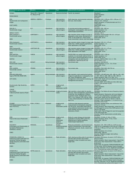
Instrument & agency (& any<br />
partners)<br />
Pamela<br />
ROSKOSMOS<br />
PAN<br />
Panchromatic and multispectral<br />
imager<br />
CAST (INPE)<br />
PAN (BJ-1)<br />
Panchromatic Imager<br />
NRSCC (CAST)<br />
PAN (Cartosat-1)<br />
Panchromatic sensor<br />
ISRO<br />
Missions Status Type Measurements & applications Technical characteristics<br />
Resurs DK 1, Resurs P<br />
N1, Resurs P N2<br />
Operational Space environment Cosmic ray research Waveband:<br />
Spatial resolution:<br />
Swath width:<br />
Accuracy:<br />
CBERS-3, CBERS-4 Prototype High resolution<br />
optical imagers<br />
BJ-1 Operational High resolution<br />
optical imagers<br />
CARTOSAT-1 Operational High resolution<br />
optical imagers<br />
Earth resources, environmental monitoring,<br />
land use, urban studies<br />
To provide panchromatica analysis of<br />
hydrological, oceanographic, land use and<br />
meteorological parameters.<br />
Waveband: 0.52 - 0.59 µm, 0.63 - 0.69 µm, 0.77 -<br />
0.89 µm, 0.51 - 0.85 µm<br />
Spatial resolution: 5 m panchromatic and 10 m<br />
multispectral<br />
Swath width: 60 km<br />
Accuracy:<br />
Waveband: 500 - 800 nm<br />
Spatial resolution: 4 m<br />
Swath width: 24 km<br />
Accuracy: 100 m<br />
High resolution stereo images for study of Waveband: Panchromatic VIS: 0.5 - 0.75 µm<br />
topography, urban areas, development of Spatial resolution: 2.5 m<br />
DTM, run-off models etc. Urban sprawl, Swath width: 30 km<br />
forest cover/timber volume, land use change Accuracy:<br />
PAN (Cartosat-2)<br />
Panchromatic Camera<br />
ISRO<br />
PAN (Cartosat-2B)<br />
Panchromatic Camera<br />
ISRO<br />
PAN (GISTDA)<br />
Panchromatic imager<br />
GISTDA<br />
PAN CAM<br />
Panchromatic Camera<br />
ASI<br />
PAN CAMERA<br />
Pancromatic camera<br />
ASI<br />
PAN+MS (RGB+NIR)<br />
Ingenio PAN+MS (RGB+NIR)<br />
CDTI (ESA)<br />
Panchromatic High Sensitivity<br />
Camera<br />
CONAE<br />
Paz SAR-X<br />
X Band Syn<strong>the</strong>tic Aperture Radar<br />
CDTI<br />
PCWMP<br />
PCW Meteorological Payload (1 on<br />
each PCW S/C)<br />
CSA<br />
PMR<br />
Passive Microwave Radiometer<br />
ISRO<br />
POLDER-P<br />
POLarization and Directionality of<br />
<strong>the</strong> Earth's Reflectances<br />
(PARASOL version)<br />
CNES<br />
POSEIDON-2 (SSALT-2)<br />
Positioning Ocean Solid Earth Ice<br />
Dynamics Orbiting Navigator<br />
(Single frequency solid state radar<br />
altimeter)<br />
CNES<br />
POSEIDON-3<br />
Positioning Ocean Solid Earth Ice<br />
Dynamics Orbiting Navigator<br />
(Single frequency solid state radar<br />
altimeter)<br />
CNES<br />
CARTOSAT-2 Operational High resolution<br />
optical imagers<br />
CARTOSAT-2B Operational High resolution<br />
optical imagers<br />
THEOS Operational High resolution<br />
optical imagers<br />
MIOSAT<br />
Being developed High resolution<br />
optical imagers<br />
PRISMA Approved High resolution<br />
optical imagers<br />
Ingenio<br />
Being developed High resolution<br />
optical imagers<br />
SARE-1 TBD Imaging multispectral<br />
radiometers (vis/IR)<br />
PAZ<br />
Being developed Imaging microwave<br />
radars<br />
High resolution stereo images for large scale<br />
(better than 1:0000) mapping applications,<br />
urban applications, GIS ingest<br />
High resolution stereo images for large scale<br />
(better than 1:0000) mapping applications,<br />
urban applications, GIS ingest<br />
Waveband: VIS: 0.5 - 0.75 µm<br />
Spatial resolution: 1 m<br />
Swath width: 10 km<br />
Accuracy:<br />
Waveband: VIS: 0.5 - 0.75 µm<br />
Spatial resolution: 1 m<br />
Swath width: 10 km<br />
Accuracy:<br />
THEOS PAN is an optical instrument with Waveband: 0.45 - 0.90 µm<br />
resolution 2 m and swath width at 22 km. It Spatial resolution: 2 m<br />
can be used in several applications such as Swath width: 22 km<br />
cartography, land use planning and Accuracy: GSD for PAN = 2 m +/- 10%<br />
management, national security, etc. MTF for PAN > 0.10<br />
Pancromatic data<br />
Waveband: 400-900 nm<br />
Spatial resolution: 2 x 2 m - 10 x 10 km<br />
Swath width: 10 km<br />
Accuracy:<br />
Pancromatic data<br />
Waveband: PAN CAM: 400-750 nm<br />
Spatial resolution: 5 m<br />
Swath width: 30 km<br />
Accuracy:<br />
High resolution multi–spectral land optical Waveband: VIS+NIR band: 450 - 680 nm, 450 - 520<br />
images for applications in cartography, land nm, 520 - 600 nm, 630 - 690 nm, 760 - 900 nm<br />
use, urban management, water<br />
Spatial resolution: PAN: 2.5 m, MS: 10 m<br />
management, environmental monitoring, risk Swath width: Swath will move between 55 and 60 Km<br />
management and security.<br />
depending on latitude.<br />
Accuracy: SNR: 100 in PAN and 120 in MS. Geolocation<br />
< 25m at level 1b (2σ).<br />
High resolution x-band radar for security,<br />
land use, urban management, environmental<br />
monitoring, risk management. Different<br />
acquisition modes: Spotlight (5x5-10 km<br />
SSD =


