

the earth observation handbook
The Earth Observation Handbook - Key Tables - SEOCA
The Earth Observation Handbook - Key Tables - SEOCA
- No tags were found...

Create successful ePaper yourself
Turn your PDF publications into a flip-book with our unique Google optimized e-Paper software.
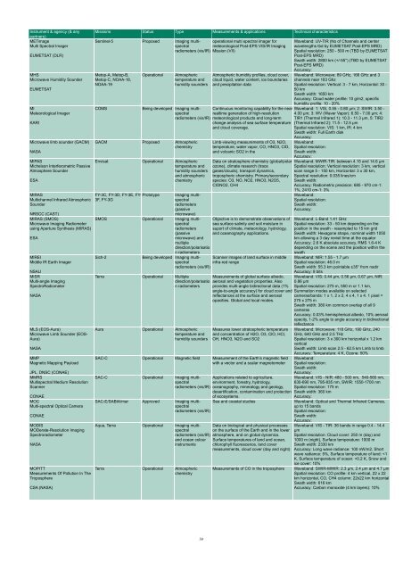
Instrument & agency (& any<br />
partners)<br />
METimage<br />
Multi Spectral Imager<br />
EUMETSAT (DLR)<br />
MHS<br />
Microwave Humidity Sounder<br />
EUMETSAT<br />
MI<br />
Meteorological Imager<br />
KARI<br />
Microwave limb sounder (GACM)<br />
NASA<br />
MIPAS<br />
Michelson Interferometric Passive<br />
Atmosphere Sounder<br />
ESA<br />
MIRAS<br />
Multichannel Infrared Atmospheric<br />
Sounder<br />
NRSCC (CAST)<br />
MIRAS (SMOS)<br />
Microwave Imaging Radiometer<br />
using Aperture Syn<strong>the</strong>sis (MIRAS)<br />
ESA<br />
MIREI<br />
Middle IR Earth Imager<br />
NSAU<br />
MISR<br />
Multi-angle Imaging<br />
SpectroRadiometer<br />
NASA<br />
MLS (EOS-Aura)<br />
Microwave Limb Sounder (EOS-<br />
Aura)<br />
NASA<br />
MMP<br />
Magnetic Mapping Payload<br />
JPL, DNSC (CONAE)<br />
MMRS<br />
Multispectral Medium Resolution<br />
Scanner<br />
CONAE<br />
MOC<br />
Multi-spectral Optical Camera<br />
CONAE<br />
MODIS<br />
MODerate-Resolution Imaging<br />
Spectroradiometer<br />
NASA<br />
MOPITT<br />
Measurements Of Pollution In The<br />
Troposphere<br />
CSA (NASA)<br />
Missions Status Type Measurements & applications Technical characteristics<br />
Sentinel-5 Proposed Imaging multispectral<br />
operational multi spectral imager for<br />
meteorological Post-EPS VIS/IR Imaging<br />
radiometers (vis/IR) Mission (VII)<br />
Metop-A, Metop-B,<br />
Metop-C, NOAA-18,<br />
NOAA-19<br />
COMS<br />
Operational<br />
Atmospheric<br />
temperature and<br />
humidity sounders<br />
Being developed Imaging multispectral<br />
radiometers (vis/IR)<br />
GACM Proposed Atmospheric<br />
chemistry<br />
Envisat Operational Atmospheric<br />
temperature and<br />
humidity sounders<br />
and atmospheric<br />
chemistry<br />
FY-3C, FY-3D, FY-3E, FY- Prototype<br />
3F, FY-3G<br />
Imaging multispectral<br />
radiometers<br />
(passive<br />
microwave)<br />
SMOS Operational Imaging multispectral<br />
radiometers<br />
(passive<br />
microwave) and<br />
multiple<br />
direction/polarisatio<br />
n radiometers<br />
Sich-2<br />
Atmospheric humidity profiles, cloud cover,<br />
cloud liquid, water content, ice boundaries<br />
and precipitation data<br />
Continuous monitoring capability for <strong>the</strong> nearrealtime<br />
generation of high-resolution<br />
meteorological products and long-term<br />
change analysis of sea surface temperature<br />
and cloud coverage.<br />
Limb-viewing measurements of O3, N2O,<br />
temperature, water vapor, CO, HNO3, ClO,<br />
and volcanic SO2 in <strong>the</strong><br />
Data on stratosphere chemistry (global/polar<br />
ozone), climate research (trace<br />
gases/clouds), transport dynamics,<br />
tropospheric chemistry. Primary/secondary<br />
species: O3, NO, NO2, HNO3, N2O5,<br />
ClONO2, CH4<br />
Objective is to demonstrate <strong>observation</strong>s of<br />
sea surface salinity and soil moisture in<br />
suport of climate, meteorology, hydrology,<br />
and oceanography applications.<br />
Being developed Imaging multispectral<br />
infra-red range<br />
Scanner images of land surface in middle<br />
radiometers (vis/IR)<br />
Waveband: UV-TIR (No of Channels and center<br />
wavelengths tbd by EUMETSAT Post-EPS MRD)<br />
Spatial resolution: 250 - 500 m (TBD by EUMETSAT<br />
Post-EPS MRD)<br />
Swath width: 2800 km (+/-55°) (TBD by EUMETSAT<br />
Post-EPS MRD)<br />
Accuracy:<br />
Waveband: Microwave: 89 GHz, 166 GHz and 3<br />
channels near 183 Ghz<br />
Spatial resolution: Vertical: 3 - 7 km, Horizontal: 30 -<br />
50 km<br />
Swath width: 1650 km<br />
Accuracy: Cloud water profile: 10 g/m2, specific<br />
humidity profile: 10 - 20%<br />
Waveband: 1: VIS, 0.55 - 0.80 µm; 2: SWIR: 3.50 -<br />
4.00 µm; 3: WV (Waver Vapor): 6.50 - 7.00 µm; 4:<br />
TIR1 (Thermal Infrared 1): 10.3 - 11.3 µm, 5: TIR2<br />
(Thermal Infrared 2): 11.5 - 12.5 µm<br />
Spatial resolution: VIS: 1 km, IR: 4 km<br />
Swath width: Full Earth disk<br />
Accuracy:<br />
Waveband:<br />
Spatial resolution:<br />
Swath width:<br />
Accuracy:<br />
Waveband: MWIR-TIR: between 4.15 and 14.6 µm<br />
Spatial resolution: Vertical resolution: 3 km, vertical<br />
scan range 5 - 150 km, Horizontal: 3 x 30 km,<br />
Spectral resolution: 0.035 lines/cm<br />
Swath width:<br />
Accuracy: Radiometric precision: 685 - 970 cm-1:<br />
1%, 2410 cm-1: 3%<br />
Waveband:<br />
Spatial resolution:<br />
Swath width:<br />
Accuracy:<br />
Waveband: L-Band 1.41 GHz<br />
Spatial resolution: 33 - 50 km depending on <strong>the</strong><br />
position in <strong>the</strong> swath - resampled to 15 km grid<br />
Swath width: Hexagone shape, nominal width 1050<br />
km allowing a 3 day revisit time at <strong>the</strong> equator<br />
Accuracy: 2.6 K absolute accuracy, RMS 1.6-4 K<br />
depending on <strong>the</strong> scene and <strong>the</strong> position within <strong>the</strong><br />
swath<br />
Waveband: NIR: 1.55 - 1.7 µm<br />
Spatial resolution: 46.0 m<br />
Swath width: 55.3 km pointable ±35° from nadir<br />
Accuracy: 8 bits<br />
Terra Operational Multiple<br />
direction/polarisatio<br />
n radiometers<br />
Measurements of global surface albedo,<br />
aerosol and vegetation properties. Also<br />
provides multi-angle bidirectional data (1%<br />
Waveband: VIS: 0.44 µm, 0.56 µm, 0.67 µm, NIR:<br />
0.86 µm<br />
Spatial resolution: 275 m, 550 m or 1.1 km,<br />
angle-to-angle accuracy) for cloud cover and Summation modes available on selected<br />
reflectances at <strong>the</strong> surface and aerosol<br />
opacities. Global and local modes.<br />
cameras/bands: 1 x 1, 2 x 2, 4 x 4, 1 x 4. 1 pixel =<br />
275 x 275 m<br />
Swath width: 380 km common overlap of all 9<br />
cameras<br />
Accuracy: 0.03% hemispherical albedo, 10% aerosol<br />
opacity, 1-2% angle to angle accuracy in bidirectional<br />
reflectance<br />
Aura Operational Atmospheric<br />
temperature and<br />
humidity sounders<br />
Measures lower stratospheric temperature<br />
and concentration of H2O, O3, ClO, HCl,<br />
OH, HNO3, N2O and SO2<br />
SAC-C Operational Magnetic field Measurement of <strong>the</strong> Earth’s magnetic field<br />
with a vector and a scalar magnetometer<br />
Waveband: Microwave: 118 GHz, 190 GHz, 240<br />
GHz, 640 GHz and 2.5 THz<br />
Spatial resolution: 3 x 300 km horizontal x 1.2 km<br />
vertical<br />
Swath width: Limb scan 2.5 - 62.5 km Limb to limb<br />
Accuracy: Temparature: 4 K, Ozone: 50%<br />
Waveband:<br />
Spatial resolution:<br />
Swath width:<br />
Accuracy:<br />
SAC-C Operational Imaging multispectral<br />
Applications related to agriculture,<br />
environment, forestry, hydrology,<br />
Waveband: VIS - NIR: 480 - 500 nm, 540-560 nm,<br />
630-690 nm, 795-835 nm, SWIR: 1550-1700 nm<br />
radiometers (vis/IR) oceanography, mineralogy and geology, Spatial resolution: 175 m<br />
desertification, contamination and protection Swath width: 360 km<br />
of ecosystems.<br />
Accuracy:<br />
SAC-E/SABIA/mar Approved Imaging multispectral<br />
radiometers (vis/IR)<br />
Aqua, Terra Operational Imaging multispectral<br />
radiometers (vis/IR)<br />
and ocean colour<br />
instruments<br />
Terra Operational Atmospheric<br />
chemistry<br />
Sea and coastal studies<br />
Data on biological and physical processes<br />
on <strong>the</strong> surface of <strong>the</strong> Earth and in <strong>the</strong> lower<br />
atmosphere, and on global dynamics.<br />
Surface temperatures of land and ocean,<br />
chlorophyll fluorescence, land cover<br />
measurements, cloud cover (day and night)<br />
Waveband: Optical and Thermal Infrared Cameras,<br />
up to 15 bands<br />
Spatial resolution:<br />
Swath width:<br />
Accuracy:<br />
Waveband: VIS - TIR: 36 bands in range 0.4 - 14.4<br />
µm<br />
Spatial resolution: Cloud cover: 250 m (day) and<br />
1000 m (night), Surface temperature: 1000 m<br />
Swath width: 2330 km<br />
Accuracy: Long wave radiance: 100 nW/m2, Short<br />
wave radiance: 5%, Surface temperature of land:


