

the earth observation handbook
The Earth Observation Handbook - Key Tables - SEOCA
The Earth Observation Handbook - Key Tables - SEOCA
- No tags were found...

Create successful ePaper yourself
Turn your PDF publications into a flip-book with our unique Google optimized e-Paper software.
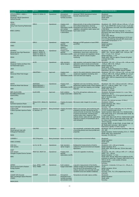
Instrument & agency (& any<br />
partners)<br />
ATOVS (HIRS/3 + AMSU +<br />
AVHRR/3)<br />
Advanced TIROS Operational<br />
Vertical Sounder<br />
Missions Status Type Measurements & applications Technical characteristics<br />
NOAA-15, NOAA-16 Operational Atmospheric<br />
temperature and<br />
humidity sounders<br />
Advanced TIROS Operational Vertical<br />
Sounder insturment suite<br />
Waveband:<br />
Spatial resolution:<br />
Swath width:<br />
Accuracy:<br />
NOAA<br />
ATSR-2<br />
Along Track Scanning Radiometer -<br />
2<br />
BNSC (CSIRO)<br />
ATSR/M<br />
CNES<br />
AVHRR/3<br />
Advanced Very High Resolution<br />
Radiometer/3<br />
NOAA<br />
AVNIR-2<br />
Advanced Visible and Near Infrared<br />
Radiometer type 2<br />
JAXA<br />
AWFI<br />
Advanced Wide Field Imager<br />
INPE<br />
AWiFS<br />
Advanced Wide Field Sensor<br />
ISRO<br />
BBR (EarthCARE)<br />
BroadBand Radiometer<br />
(EarthCARE)<br />
ESA<br />
BRLK<br />
Syn<strong>the</strong>tic Aperature Radar<br />
ROSHYDROMET (ROSKOSMOS)<br />
C-Band SAR<br />
C-Band Syn<strong>the</strong>tic Aperture Radar<br />
ESA<br />
CALIOP<br />
Cloud-Aerosol Lidar with<br />
Orthogonal Polarization<br />
NASA<br />
CARMEN-1<br />
CNES (CONAE)<br />
CCD (HJ)<br />
CCD camera<br />
CAST<br />
CCD camera<br />
Charged Coupled Device Camera<br />
ISRO<br />
CERES<br />
Cloud and <strong>the</strong> Earth's Radiant<br />
Energy System<br />
NASA<br />
CHAMP GPS Sounder<br />
GPS TurboRogue Space Receiver<br />
(TRSR)<br />
NASA (DLR)<br />
ERS-2 Operational Imaging multispectral<br />
radiometers (vis/IR)<br />
and multiple<br />
direction/polarisatio<br />
n radiometers<br />
ERS-2 Operational Imaging multispectral<br />
radiometers<br />
(passive<br />
microwave)<br />
Metop-A, Metop-B,<br />
Metop-C, NOAA-15,<br />
NOAA-16, NOAA-17,<br />
NOAA-18, NOAA-19<br />
Operational<br />
ALOS Operational High resolution<br />
optical imagers<br />
Measurements of sea surface temperature,<br />
land surface temperature, cloud top<br />
temperature and cloud cover, aerosols,<br />
vegetation, atmospheric water vapour and<br />
liquid water content<br />
Belongs to ATSR payload on board ERS1<br />
and ERS2<br />
Imaging multispectral<br />
temperature, cloud cover, snow and ice<br />
Measurements of land and sea surface<br />
radiometers (vis/IR) cover, soil moisture and vegetation indices.<br />
Data also used for volcanic eruption<br />
monitoring<br />
High resolution multi-spectral imager for land<br />
applications which include environmental<br />
monitoring, agriculture and forestry, disaster<br />
monitoring<br />
AMAZÔNIA-1 Approved Imaging multispectral<br />
Used for fire extent detection measurement,<br />
coastal and vegetation monitoring, land<br />
radiometers (vis/IR) cover and land use mapping<br />
AWiFSSAT,<br />
RESOURCESAT-1,<br />
RESOURCESAT-2<br />
Operational<br />
Imaging multispectral<br />
Vegetation and crop monitoring, resource<br />
radiometers (vis/IR)<br />
assessment (regional scale), forest mapping,<br />
land cover/ land use mapping, and change<br />
detection<br />
EarthCARE Approved Earth radiation Top of <strong>the</strong> atmosphere radiances and<br />
budget radiometers radiative flux<br />
Meteor-M N1, Meteor-M<br />
N2<br />
Sentinel-1 A, Sentinel-1<br />
B, Sentinel-1 C<br />
Operational<br />
Imaging microwave<br />
radars<br />
Being developed Imaging microwave<br />
radars<br />
Microwave radar images for ice watch<br />
Marine core services, land monitoring and<br />
emergency services. Monitoring sea ice<br />
zones and arctic environment. Surveillance<br />
of marine environment, monitoring land<br />
surface motion risks, mapping of land<br />
surfaces (forest, water and soil, agriculture),<br />
mapping in support of humanitarian aid in<br />
crisis situations<br />
CALIPSO Operational Lidars Two-wavelength, polarisation lidar capable<br />
of providing aerosol and cloud profiles and<br />
properties<br />
SAC-D/Aquarius Being developed Space environment Studying space environment effects Waveband:<br />
Spatial resolution:<br />
Swath width:<br />
Accuracy:<br />
HJ-1A, HJ-1B Operational High resolution<br />
optical imagers<br />
Multispectral measurements of Earth's<br />
surface for natural enviroment and disaster<br />
applications<br />
INSAT-2E, INSAT-3A Operational Imaging multispectral<br />
Cloud and vegetation monitoring<br />
radiometers (vis/IR)<br />
Aqua, JPSS-1, NPP,<br />
Terra, TRMM<br />
Operational<br />
CHAMP Operational Atmospheric<br />
temperature and<br />
humidity sounders<br />
and precision orbit<br />
Earth radiation Long term measurement of <strong>the</strong> Earth's<br />
budget radiometers radiation budget and atmospheric radiation<br />
from <strong>the</strong> top of <strong>the</strong> atmosphere to <strong>the</strong><br />
surface; provision of an accurate and selfconsistent<br />
cloud and radiation database.<br />
Temperature and water vapour profiles<br />
Waveband: VIS - SWIR: 0.65 µm, 0.85 µm, 1.27 µm,<br />
and 1.6 µm, SWIR-TIR: 1.6 µm, 3.7 µm, 11 µm and<br />
12 µm, Microwave: 23.8 GHz, 36.5 GHz (bandwidth<br />
of 400 MHz)<br />
Spatial resolution: IR ocean channels: 1 x 1 km,<br />
Microwave near-nadir viewing: 20 km instantaneous<br />
field of view<br />
Swath width: 500 km<br />
Accuracy: Sea surface temperature to


