

the earth observation handbook
The Earth Observation Handbook - Key Tables - SEOCA
The Earth Observation Handbook - Key Tables - SEOCA
- No tags were found...

You also want an ePaper? Increase the reach of your titles
YUMPU automatically turns print PDFs into web optimized ePapers that Google loves.
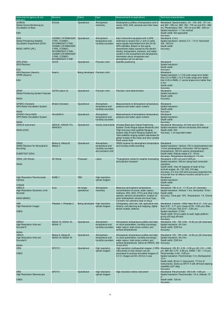
Instrument & agency (& any<br />
partners)<br />
GOMOS<br />
Global Ozone Monitoring by<br />
Occultation of Stars<br />
ESA<br />
GOX<br />
Global Positioning Satellite<br />
Occultation Experiment (GOX)<br />
NASA, NSPO (JPL)<br />
GPS (ESA)<br />
GPS Receiver<br />
ESA<br />
GPS Receiver (Swarm)<br />
GPSR (Swarm)<br />
ESA<br />
GPSP<br />
Global Positioning System Payload<br />
NASA<br />
Missions Status Type Measurements & applications Technical characteristics<br />
Envisat Operational Atmospheric<br />
chemistry<br />
COSMIC-1/FORMOSAT-<br />
3 FM1, COSMIC-<br />
2/FORMOSAT-3 FM2,<br />
COSMIC-3/FORMOSAT-<br />
3 FM3, COSMIC-<br />
4/FORMOSAT-3 FM4,<br />
COSMIC-5/FORMOSAT-<br />
3 FM5, COSMIC-<br />
6/FORMOSAT-3 FM6<br />
Operational<br />
Atmospheric<br />
temperature and<br />
humidity sounders<br />
Stratospheric profiles of temparature and of<br />
ozone, NO2, H20, aerosols and o<strong>the</strong>r trace<br />
species<br />
Each instrument equipped with 4 GPS<br />
antennas to receive <strong>the</strong> L1 and L2 radio<br />
wave signals transmitted from <strong>the</strong> 24 US<br />
GPS satellites. Based on <strong>the</strong> signal<br />
transmission delay caused by <strong>the</strong> electric<br />
density, temperature, pressure, and water<br />
content in <strong>the</strong> ionosphere and atmosphere,<br />
information about ionosphere and<br />
atmosphere can be derived.<br />
Waveband: Spectrometers: UV - VIS: 248 - 371 nm<br />
and 387 - 693 nm, NIR: 750 - 776 nm and 915 - 956<br />
nm, Photometers: 644 - 705 nm and 466 - 528 nm<br />
Spatial resolution: 1.7 km vertical<br />
Swath width: Not applicable<br />
Accuracy:<br />
Waveband: L1/L2<br />
Spatial resolution: Vertical: 0.3 - 1.5 m; Horizontal:<br />
300 - 600 km<br />
Swath width:<br />
Accuracy:<br />
GOCE Operational Precision orbit Satellite positioning Waveband:<br />
Spatial resolution:<br />
Swath width:<br />
Accuracy:<br />
Swarm Being developed Precision orbit Waveband:<br />
Spatial resolution: L1 C/A code range error better<br />
than 0.5 m RMS; L1/L2 P-code range error better<br />
than 0.25 m RMS; L1 carrier phase error better than<br />
5 mm<br />
Swath width:<br />
Accuracy:<br />
OSTM (Jason-2) Operational Precision orbit Precision orbit determination Waveband:<br />
Spatial resolution:<br />
Swath width:<br />
Accuracy:<br />
GPSRO (Oersted)<br />
GPS Radio Occultation System<br />
NASA<br />
GPSRO (Terra-SAR)<br />
GPS Radio Occultation System<br />
NASA<br />
GRACE instrument<br />
NASA (DLR)<br />
GRAS<br />
GNSS Receiver for Atmospheric<br />
Sounding<br />
EUMETSAT (ESA)<br />
HDWL (3D Winds)<br />
NASA<br />
High Resolution Panchromatic<br />
Camera<br />
CONAE<br />
HiRDLS<br />
High Resolution Dynamics Limb<br />
Sounder<br />
NASA (BNSC)<br />
HiRI<br />
High-Resolution Imager<br />
CNES<br />
HIRS/3<br />
High Resolution Infra-red<br />
Sounder/3<br />
NOAA<br />
HIRS/4<br />
High Resolution Infra-red<br />
Sounder/4<br />
NOAA<br />
HRG<br />
CNES<br />
HRS<br />
High Resolution Stereoscope<br />
CNES<br />
Ørsted (Oersted) Operational Atmospheric<br />
temperature and<br />
humidity sounders<br />
TerraSAR-X Operational Atmospheric<br />
temperature and<br />
humidity sounders<br />
GRACE, GRACE FO,<br />
GRACE-II<br />
Metop-A, Metop-B,<br />
Metop-C<br />
Operational<br />
Operational<br />
Measurements of atmospheric temperature,<br />
pressure and water vapor content.<br />
Measurements of atmospheric temperature,<br />
pressure and water vapor content.<br />
Waveband:<br />
Spatial resolution:<br />
Swath width:<br />
Accuracy:<br />
Waveband:<br />
Spatial resolution:<br />
Swath width:<br />
Accuracy:<br />
Gravity instruments Includes BlackJack Global Positioning Waveband: Microwave: 24 GHz and 32 GHz<br />
System (Turbo Rogue Space Receiver) and Spatial resolution: 400 km horizontal, N/A vertical<br />
'High Accuracy Inter-satellite Ranging Swath width: N/A<br />
System (aka K-band Ranging System) for Accuracy: 1 cm equivilant water<br />
'Inter-satellilte ranging system estimestes for<br />
global models of <strong>the</strong> mean and time variable<br />
Earth gravity field<br />
Atmospheric<br />
temperature and<br />
humidity sounders<br />
and precision orbit<br />
GNSS receiver for atmospheric temperature<br />
and humidty profile sounding<br />
3D Winds Proposed Lidars "Tropospheric winds for wea<strong>the</strong>r forecasting<br />
and pollution transport<br />
SARE-1 TBD High resolution<br />
optical imagers<br />
Aura<br />
Pleiades 1, Pleiades 2<br />
NOAA-15, NOAA-16,<br />
NOAA-17<br />
Metop-A, Metop-B,<br />
NOAA-18, NOAA-19<br />
No longer<br />
operational<br />
Atmospheric<br />
chemistry<br />
Being developed High resolution<br />
optical imagers<br />
Operational<br />
Operational<br />
Atmospheric<br />
temperature and<br />
humidity sounders<br />
Atmospheric<br />
temperature and<br />
humidity sounders<br />
SPOT-5 Operational High resolution<br />
optical imagers<br />
SPOT-5 Operational High resolution<br />
optical imagers<br />
Waveband:<br />
Spatial resolution: Vertical: 150 m (trophosphere) and<br />
1.5 km (stratosphere), Horizontal: 100 km approx<br />
(troposphere), 300 km approx (stratosphere)<br />
Swath width: Altitude range of 5 - 30 km<br />
Accuracy: Temperature sounding to 1 K rms<br />
Waveband: 2.051 µm and 0.355 µm<br />
Spatial resolution: 300 km along track horizontal<br />
resolution<br />
Swath width: View 45 degrees of nadir at four<br />
azimuth angles: 45, 135, 225, 315 deg.<br />
Accuracy: 2-3 m/s LOS wind accuracy projected into<br />
horizontal from all effects including sampling error<br />
Waveband:<br />
Spatial resolution:<br />
Swath width:<br />
Accuracy:<br />
Measures atmospheric temperature, Waveband: TIR: 6.12 - 17.76 µm (21 channels)<br />
concentrations of ozone, water vapour, Spatial resolution: Vertical: 1 km, Horizontal: 10 km<br />
methane, NOx, N2O, CFCs and o<strong>the</strong>r minor Swath width:<br />
species, aerosol concentration, location of Accuracy: Trace gas: 10%, Temparature: 1 K, Ozone:<br />
polar stratospheric clouds and cloud tops. 10%<br />
Currently not collecting data on Aqua.<br />
Cartography, land use, risk, agriculture and<br />
forestry, civil planning and mapping, digital<br />
terrain models, defence<br />
Atmospheric temperature profiles and data<br />
on cloud parameters, humidity soundings,<br />
water vapour, total ozone content, and<br />
surface temperatures<br />
Waveband: 4 bands + PAN: Near IR (0.77 - 0.91 µm),<br />
Red (0.61 - 0.71 µm), Green (0.50 - 0.60 µm), Blue<br />
(0.44 - 0.54 µm), Pan (0.47 - 0.84 µm)<br />
Spatial resolution: 0.70m<br />
Swath width: 20 km swath at nadir. Agile platform<br />
giving ±50 deg off-track<br />
Accuracy:<br />
Waveband: VIS - TIR: 0.69 - 14.95 µm (20 channels)<br />
Spatial resolution: 20.3 km<br />
Swath width: 2240 km<br />
Accuracy:<br />
Atmospheric temperature profiles and data Waveband: VIS - TIR: 0.69 - 14.95 µm (20 channels)<br />
on cloud parameters, humidity soundings, Spatial resolution: 20.3 km<br />
water vapour, total ozone content, and Swath width: 2240 km<br />
surface temperatures. Same as HIRS/3, with Accuracy:<br />
10 km IFOV<br />
High resolution multispectral mapper. 2 HRG<br />
instruments on this mission can be<br />
processed to produce simulated imagery of<br />
2.5 m. Images are 60 x 60 km in size<br />
Waveband: VIS: B1: 0.50 - 0.59 µm, B2: 0.61 - 0.68<br />
µm, NIR: B3: 0.79 - 0.89 µm, SWIR: 1.50 - 1.75 µm,<br />
Panchromatic: 0.49 - 0.69 µm<br />
Spatial resolution: Panchromatic: 5 m, Multispectral:<br />
10 m<br />
Swath width: 60 km (1 instrument), 117 km (2<br />
instruments). Same as SPOT 4 with off-track steering<br />
capability (±27 deg)<br />
Accuracy:<br />
High resolution stereo instrument Waveband: Panchromatic: VIS 0.49 - 0.69 µm<br />
Spatial resolution: Panchromatic: 10 m, Altitude: 15<br />
m<br />
Swath width: 120 km<br />
Accuracy:<br />
34


