

the earth observation handbook
The Earth Observation Handbook - Key Tables - SEOCA
The Earth Observation Handbook - Key Tables - SEOCA
- No tags were found...

Create successful ePaper yourself
Turn your PDF publications into a flip-book with our unique Google optimized e-Paper software.
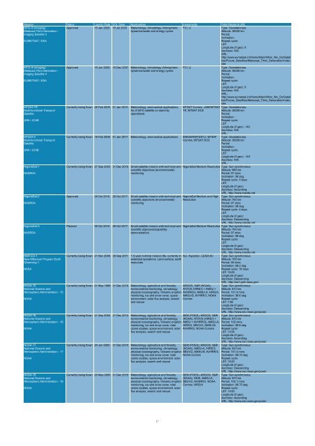
Mission Status Launch Date EOL Date Applications Instruments Orbit Details & URL<br />
MTG-I3 (imaging)<br />
Meteosat Third Generation -<br />
Imaging Satellite 3<br />
EUMETSAT / ESA<br />
Approved 15 Jan 2025 15 Jul 2033 Meteorology, climatology, Atmospheric<br />
dynamics/water and energy cycles<br />
FCI, LI<br />
Type: Geostationary<br />
Altitude: 36000 km<br />
Period:<br />
Inclination:<br />
Repeat cycle:<br />
LST:<br />
Longitude (if geo): 0<br />
Asc/desc: N/A<br />
URL:<br />
http://www.eumetsat.int/Home/Main/What_We_Do/Satell<br />
ites/Future_Satellites/Meteosat_Third_Generation/index.<br />
htm<br />
MTG-I4 (imaging)<br />
Meteosat Third Generation -<br />
Imaging Satellite 4<br />
EUMETSAT / ESA<br />
MTSAT-1R<br />
Multi-functional Transport<br />
Satellite<br />
JMA / JCAB<br />
MTSAT-2<br />
Multi-functional Transport<br />
Satellite<br />
JMA / JCAB<br />
NigeriaSat-1<br />
NASRDA<br />
NigeriaSat-2<br />
NASRDA<br />
NigeriaSat-X<br />
NASRDA<br />
NMP EO-1<br />
New Millenium Program Earth<br />
Observing-1<br />
NASA<br />
NOAA-15<br />
National Oceanic and<br />
Atmospheric Administration - 15<br />
NOAA<br />
NOAA-16<br />
National Oceanic and<br />
Atmospheric Administration - 16<br />
NOAA<br />
NOAA-17<br />
National Oceanic and<br />
Atmospheric Administration - 17<br />
NOAA<br />
NOAA-18<br />
National Oceanic and<br />
Atmospheric Administration - 18<br />
NOAA<br />
Approved 15 Jun 2029 15 Dec 2037 Meteorology, climatology, Atmospheric<br />
dynamics/water and energy cycles<br />
Currently being flown 26 Feb 2005 01 Jan 2015 Meteorology, aeronautical applications.<br />
As of 2010 satellite on stand-by<br />
operational.<br />
Currently being flown 18 Feb 2006 01 Jan 2017 Meteorology, aeronautical applications IMAGER/MTSAT-2, MTSAT<br />
Comms, MTSAT DCS<br />
Currently being flown 27 Sep 2003 31 Dec 2010 Small satellite mission with technical and<br />
scientific objectives (environmental)<br />
monitoring<br />
Approved 29 Oct 2010 29 Oct 2017 Small satellite mission with technical and<br />
scientific objectives (environmental)<br />
monitoring<br />
Planned 29 Oct 2010 29 Oct 2017 Small satellite mission with technical and<br />
scientific objectives(capability<br />
demonstration)<br />
FCI, LI<br />
Type: Geostationary<br />
Altitude: 36000 km<br />
Period:<br />
Inclination:<br />
Repeat cycle:<br />
LST:<br />
Longitude (if geo): 0<br />
Asc/desc: N/A<br />
URL:<br />
http://www.eumetsat.int/Home/Main/What_We_Do/Satell<br />
ites/Future_Satellites/Meteosat_Third_Generation/index.<br />
htm<br />
MTSAT Comms, JAMI/MTSAT- Type: Geostationary<br />
1R, MTSAT DCS<br />
Altitude: 36000 km<br />
Period:<br />
Inclination:<br />
Repeat cycle:<br />
LST:<br />
Longitude (if geo): -140<br />
Asc/desc: N/A<br />
URL:<br />
Type: Geostationary<br />
Altitude: 36000 km<br />
Period:<br />
Inclination:<br />
Repeat cycle:<br />
LST:<br />
Longitude (if geo): -145<br />
Asc/desc: N/A<br />
URL:<br />
NigeriaSat Medium Resolution Type: Sun-synchronous<br />
Altitude: 686 km<br />
Period: 97 mins<br />
Inclination: 98 deg<br />
Repeat cycle: 3 days<br />
LST:<br />
Longitude (if geo):<br />
Asc/desc: Ascending<br />
URL: http://www.nasrda.net<br />
NigeriaSat Medium and High<br />
Resolution<br />
Currently being flown 21 Nov 2000 30 Sep 2011 1.5-year nominal mission life, currently in ALI, Hyperion, LEISA AC<br />
extended operations. Land surface, <strong>earth</strong><br />
resources<br />
Currently being flown 01 May 1998 31 Dec 2010 Meteorology, agriculture and forestry,<br />
environmental monitoring, climatology,<br />
physical oceanography, Volcanic eruption<br />
monitoring, ice and snow cover, space<br />
environment, solar flux analysis, search<br />
and rescue<br />
Currently being flown 21 Sep 2000 31 Dec 2012 Meteorology, agriculture and forestry,<br />
environmental monitoring, climatology,<br />
physical oceanography, Volcanic eruption<br />
monitoring, ice and snow cover, total<br />
ozone studies, space environment, solar<br />
flux analysis, search and rescue<br />
Currently being flown 24 Jun 2002 31 Dec 2014 Meteorology, agriculture and forestry,<br />
environmental monitoring, climatology,<br />
physical oceanography, Volcanic eruption<br />
monitoring, ice and snow cover, total<br />
ozone studies, space environment, solar<br />
flux analysis, search and rescue<br />
Currently being flown 20 May 2005 31 Dec 2015 Meteorology, agriculture and forestry,<br />
environmental monitoring, climatology,<br />
physical oceanography, Volcanic eruption<br />
monitoring, ice and snow cover, total<br />
ozone studies, space environment, solar<br />
flux analysis, search and rescue<br />
Type: Sun-synchronous<br />
Altitude: 700 km<br />
Period: 97 mins<br />
Inclination: 98 deg<br />
Repeat cycle: 4 days<br />
LST:<br />
Longitude (if geo):<br />
Asc/desc: Descending<br />
URL: http://www.nasrda.net<br />
NigeriaSat Medium Resolution Type: Sun-synchronous<br />
Altitude: 700 km<br />
Period: 97 mins<br />
Inclination: 98 deg<br />
Repeat cycle:<br />
LST:<br />
Longitude (if geo):<br />
Asc/desc: Descending<br />
URL: http://www.nasrda.net<br />
ARGOS, S&R (NOAA),<br />
ATOVS (HIRS/3 + AMSU +<br />
AVHRR/3), AMSU-A, HIRS/3,<br />
AMSU-B, AVHRR/3, NOAA<br />
Comms<br />
SEM (POES), ARGOS, S&R<br />
(NOAA), ATOVS (HIRS/3 +<br />
AMSU + AVHRR/3), AMSU-A,<br />
HIRS/3, SBUV/2, AMSU-B,<br />
AVHRR/3, NOAA Comms<br />
SEM (POES), ARGOS, S&R<br />
(NOAA), AMSU-A, HIRS/3,<br />
SBUV/2, AMSU-B, AVHRR/3,<br />
NOAA Comms<br />
SEM (POES), ARGOS, S&R<br />
(NOAA), MHS, AMSU-A,<br />
SBUV/2, AVHRR/3, NOAA<br />
Comms, HIRS/4<br />
Type: Sun-synchronous<br />
Altitude: 705 km<br />
Period: 99 mins<br />
Inclination: 98.2 deg<br />
Repeat cycle: 16 days<br />
LST: 10:00<br />
Longitude (if geo):<br />
Asc/desc: Descending<br />
URL: http://eo1.gsfc.nasa.gov/<br />
Type: Sun-synchronous<br />
Altitude: 813 km<br />
Period: 101.4 mins<br />
Inclination: 98.6 deg<br />
Repeat cycle:<br />
LST: 7:08<br />
Longitude (if geo):<br />
Asc/desc: Descending<br />
URL: http://www.oso.noaa.gov/poes/<br />
Type: Sun-synchronous<br />
Altitude: 870 km<br />
Period: 102 mins<br />
Inclination: 98.8 deg<br />
Repeat cycle:<br />
LST: 13:54<br />
Longitude (if geo):<br />
Asc/desc: Ascending<br />
URL: http://www.oso.noaa.gov/poes/<br />
Type: Sun-synchronous<br />
Altitude: 833 km<br />
Period: 101.4 mins<br />
Inclination: 98.75 deg<br />
Repeat cycle:<br />
LST: 10:00<br />
Longitude (if geo):<br />
Asc/desc: Descending<br />
URL: http://www.oso.noaa.gov/poes/<br />
Type: Sun-synchronous<br />
Altitude: 870 km<br />
Period: 102.1 mins<br />
Inclination: 98.75 deg<br />
Repeat cycle:<br />
LST: 14:00<br />
Longitude (if geo):<br />
Asc/desc: Ascending<br />
URL: http://www.oso.noaa.gov/poes/<br />
17


