the earth observation handbook
The Earth Observation Handbook - Key Tables - SEOCA
The Earth Observation Handbook - Key Tables - SEOCA
- No tags were found...
Create successful ePaper yourself
Turn your PDF publications into a flip-book with our unique Google optimized e-Paper software.
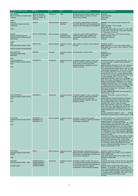
Instrument & agency (& any<br />
partners)<br />
S&R (NOAA)<br />
Metop-A, Metop-B,<br />
Search and Rescue Satellite Aided NOAA-15, NOAA-16,<br />
Tracking<br />
NOAA-17, NOAA-18,<br />
NOAA-19<br />
NOAA<br />
SAGE-III<br />
SAGE-III<br />
Stratospheric Aerosol and Gas<br />
Experiment<br />
NASA<br />
SAPHIR<br />
Sondeur Atmospherique du<br />
Profil'd’Humidite Intertropicale par<br />
Radiometrie<br />
Missions Status Type Measurements & applications Technical characteristics<br />
MEGHA-TROPIQUES<br />
Operational O<strong>the</strong>r Satellite and ground based system to detect<br />
and locate aviators, mariners, and landbased<br />
users in distress.<br />
Being developed Atmospheric<br />
chemistry<br />
Being developed Atmospheric<br />
temperature and<br />
humidity sounders<br />
Waveband:<br />
Spatial resolution:<br />
Swath width:<br />
Accuracy:<br />
Limb-viewing measurements of aerosols, Waveband: Nine spectral regions between 290 -<br />
O3, OClO, N2O NO3, H2O, temperature and 1550 nm<br />
pressure in <strong>the</strong> straosphere and mesophere Spatial resolution: 1-2 km vertical<br />
Swath width: N/A<br />
Accuracy: Aerosol profile: 5%, H20: 10 - 15%; NO2:<br />
10-15%; NO3: 10%; O3: 5%; OClO: 25%; Pressure:<br />
2%; Temperature Profile; 2K<br />
Cross-track sounder with <strong>the</strong> objective of<br />
measuring water vapour profiles in <strong>the</strong><br />
troposphere in six layers from 2-12km<br />
altitudes.<br />
Waveband: Microwave: 183.3 GHz (6 channels)<br />
Spatial resolution: 10 km<br />
Swath width: 2200 km<br />
Accuracy:<br />
CNES<br />
SAR<br />
Syn<strong>the</strong>tic Aperture Radar X band<br />
ROSHYDROMET (ROSKOSMOS)<br />
Meteor-M N3<br />
Being developed Imaging microwave<br />
radars<br />
High resolution microwave radar images for<br />
ice watch<br />
Waveband: X-Band<br />
Spatial resolution: 1 m, 5 m, 50 m, 200 m, 500 m<br />
Swath width: 10 km, 50 km, 130 km, 600 km, 750 km<br />
Accuracy: 1 dB<br />
SAR (MAPSAR)<br />
Syn<strong>the</strong>tic Aperture Radar<br />
(MAPSAR)<br />
INPE<br />
SAR (RADARSAT-2)<br />
Syn<strong>the</strong>tic Aperture Radar (CSA) C<br />
band<br />
CSA<br />
SAR (RADARSAT)<br />
Syn<strong>the</strong>tic Aperture Radar (CSA) C<br />
band<br />
CSA<br />
MAPSAR Proposed Imaging microwave<br />
radars<br />
RADARSAT-2 Operational Imaging microwave<br />
radars<br />
RADARSAT-1 Operational Imaging microwave<br />
radars<br />
Multi-Application Purpose Radar<br />
All-wea<strong>the</strong>r images of ocean, ice and land<br />
surfaces. Used for monitoring of coastal<br />
zones, polar ice, sea ice, sea state,<br />
geological features, vegetation and land<br />
surface processes<br />
All-wea<strong>the</strong>r images of ocean, ice and land<br />
surfaces. Used for monitoring of coastal<br />
zones, polar ice, sea ice, sea state,<br />
geological features, vegetation and land<br />
surface processes<br />
Waveband:<br />
Spatial resolution:<br />
Swath width:<br />
Accuracy:<br />
Waveband: Microwave: C band 5.405 GHz. HH, VV,<br />
HV, VH polarization - includes Quad polarization<br />
imaging modes.<br />
Spatial resolution: Standard: 27-18 x 25 m (4 looks);<br />
Wide: 40-19 x 25 m (4 looks); Fine: 10-7 x 8 m (1<br />
look); ScanSAR (N/W): 80-38 x 60 m / 160-172 x 100<br />
m (4/8 looks); Extended (H/L): 18-16 x 25 m / 60-23 x<br />
25 m (4 looks); Ultra-Fine: 4.6-2.1 x 2.8 m (1 look);<br />
Fine Quad-Pol: 14-8 x 8 m (1 look); Standard Quad-<br />
Pol: 24-17 x 8 m (1 look); Multi-Look Fine: 10-7 x 8 m<br />
(4 looks); Spotlight: 4.6-2.1 x 0.8 m (1 look).<br />
Swath width: Standard: 100 km (inc.: 20-49deg);<br />
Wide: 150 km (inc.: 20-45deg); Fine: 50 km (inc.: 30-<br />
50deg); ScanSAR (N/W): 300/500 km (inc.: 20-46 /<br />
20-49deg); Extended (H/L): 75/170 km (inc.: 49-60 /<br />
10-23deg); Ultra-Fine: 20 km (inc.: 20-49deg); Quad-<br />
Pol (Standard and Fine): 25 km (inc.: 20-41deg);<br />
Multi-Look Fine: 50 km (inc.: 30-50deg). Left- and<br />
right-looking capability.<br />
Accuracy: Relative Radiometric Accuracy (within a<br />
100km scene):


