

the earth observation handbook
The Earth Observation Handbook - Key Tables - SEOCA
The Earth Observation Handbook - Key Tables - SEOCA
- No tags were found...

You also want an ePaper? Increase the reach of your titles
YUMPU automatically turns print PDFs into web optimized ePapers that Google loves.
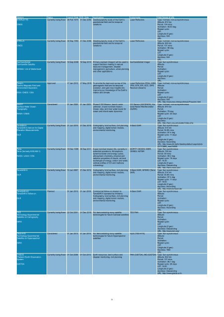
Mission Status Launch Date EOL Date Applications Instruments Orbit Details & URL<br />
STARLETTE<br />
CNES<br />
Currently being flown 06 Feb 1975 31 Dec 2050 Geodesy/gravity study of <strong>the</strong> Earth’s<br />
gravitational field and its temporal<br />
variations<br />
Laser Reflectors<br />
Type: Inclined, non-sunsynchronous<br />
Altitude: 812 km<br />
Period: 104 mins<br />
Inclination: 49.83 deg<br />
Repeat cycle:<br />
LST:<br />
Longitude (if geo):<br />
Asc/desc: N/A<br />
URL:<br />
STELLA<br />
CNES<br />
SumbandilaSat<br />
Sumbandila Satellite<br />
SANSA / Uni of Stellenbosh<br />
Swarm<br />
Earth's Magnetic Field and<br />
Environment Explorers;<br />
ESA / CNES / CSA<br />
SWOT<br />
Surface Water Ocean<br />
Topography<br />
NASA / CNES<br />
TanDEM-X<br />
TerraSAR-X Add-on for Digital<br />
Elevation Measurements<br />
DLR<br />
Terra<br />
Terra (formerly EOS AM-1)<br />
NASA / JAXA / CSA<br />
TerraSAR-X<br />
DLR<br />
TerraSAR-X2<br />
TerraSAR-X follow-on<br />
DLR<br />
TES<br />
Technology Experimental<br />
Satellite on Cartography<br />
ISRO<br />
TES-HYS<br />
Technology Experimental<br />
Satellite on Hyperspectral<br />
ISRO<br />
THEOS<br />
Thailand Earth Observation<br />
System<br />
GISTDA<br />
Currently being flown 30 Sep 1993 31 Dec 2050 Geodesy/gravity study of <strong>the</strong> Earth’s<br />
gravitational field and its temporal<br />
variations<br />
Laser Reflectors<br />
Currently being flown 18 Sep 2009 18 Sep 2014 Primary payload (imager) will be used to SumbandilaSat Imager<br />
support decision making in natural<br />
resource management, disaster<br />
management, agriculture, urban planning<br />
and o<strong>the</strong>r applications.<br />
Approved 17 Jan 2012 17 May 2016 To provide <strong>the</strong> best ever survey of <strong>the</strong><br />
geomagnetic field and its temporal<br />
evolution, and gain new insights into<br />
improving our knowledge of <strong>the</strong> Earth’s<br />
interior and climate.<br />
Considered 01 Jan 2020 01 Jan 2023 Phase-2 DS Mission, launch order<br />
unknown, 3-year nominal mission.<br />
Ocean, lake, and river water levels for<br />
ocean and inland water dynamics<br />
Currently being flown 21 Jun 2010 31 Dec 2015 Cartography, land surface, civil planning<br />
and mapping, digital terrain models,<br />
environmental monitoring.<br />
Currently being flown 18 Dec 1999 30 Sep 2011 6-year nominal mission life, currently in<br />
extended operations. Atmospheric<br />
dynamics/water and energy cycles,<br />
atmospheric chemistry, physical and<br />
radiative properties of clouds, air-land<br />
exchanges of energy, carbon and water,<br />
vertical profiles of CO and methane<br />
vulcanology<br />
Currently being flown 15 Jun 2007 31 Dec 2012 Cartography, land surface, civil planning<br />
and mapping, digital terrain models,<br />
environmental monitoring.<br />
Planned 01 Jan 2013 01 Jan 2018 Commercial follow-on mission to<br />
TerraSAR-X operated by Infoterra.<br />
Cartography, land surface, civil planning<br />
and mapping, digital terrain models,<br />
environmental monitoring.<br />
Laser Reflectors (ESA), ASM,<br />
VFM, STR, EFI, ACC, GPS<br />
Receiver (Swarm)<br />
CO Sensor (ASCENDS), Kaband<br />
Radar INterferometer<br />
(KaRIN)<br />
X-Band SAR<br />
MOPITT, MODIS, MISR,<br />
CERES, ASTER<br />
X-Band SAR, GPSRO (Terra-<br />
SAR)<br />
X-Band SAR<br />
Currently being flown 22 Oct 2001 31 Dec 2010 For demonstrating many satellite TES PAN<br />
technologies for future Cartosat satellites<br />
Considered 01 Jan 2013 01 Jan 2014 For demonstrating many satellite<br />
technologies for future Hyperspectral<br />
satellites<br />
Currently being flown 01 Oct 2008 01 Oct 2013 Earth resources, land surface and<br />
disaster monitoring, civil planning<br />
HySI (TES-HYS)<br />
Type: Inclined, non-sunsynchronous<br />
Altitude: 830 km<br />
Period: 101 mins<br />
Inclination: 98 deg<br />
Repeat cycle:<br />
LST:<br />
Longitude (if geo):<br />
Asc/desc: N/A<br />
URL:<br />
Type: Sun-synchronous<br />
Altitude:<br />
Period:<br />
Inclination:<br />
Repeat cycle:<br />
LST:<br />
Longitude (if geo):<br />
Asc/desc:<br />
URL:<br />
Type: Inclined, non-sunsynchronous<br />
Altitude:<br />
Period:<br />
Inclination:<br />
Repeat cycle:<br />
LST:<br />
Longitude (if geo):<br />
Asc/desc: N/A<br />
URL: http://www.esa.int/export/esaLP/swarm.html<br />
Type: Inclined, non-sunsynchronous<br />
Altitude: 970 km<br />
Period:<br />
Inclination: 78 deg<br />
Repeat cycle: 22 days<br />
LST:<br />
Longitude (if geo):<br />
Asc/desc:<br />
URL: http://bprc.osu.edu/water/index.php<br />
Type: Sun-synchronous<br />
Altitude: 514 km<br />
Period: 94.85 mins<br />
Inclination: 97.4 deg<br />
Repeat cycle: 11 days<br />
LST:<br />
Longitude (if geo):<br />
Asc/desc: Ascending<br />
URL: http://www.dlr.de/hr/desktopdefault.aspx/tabid-<br />
2317/3669_read-5488/<br />
Type: Sun-synchronous<br />
Altitude: 705 km<br />
Period: 99 mins<br />
Inclination: 98.2 deg<br />
Repeat cycle: 16 days<br />
LST: 10:30<br />
Longitude (if geo):<br />
Asc/desc: Descending<br />
URL: http://terra.nasa.gov/<br />
Type: Sun-synchronous<br />
Altitude: 514 km<br />
Period: 94.85 mins<br />
Inclination: 97.4 deg<br />
Repeat cycle: 11 days<br />
LST: 18:00<br />
Longitude (if geo):<br />
Asc/desc: Ascending<br />
URL: http://www.terrasar.de/<br />
Type: Sun-synchronous<br />
Altitude:<br />
Period:<br />
Inclination:<br />
Repeat cycle:<br />
LST:<br />
Longitude (if geo):<br />
Asc/desc: Ascending<br />
URL:<br />
Type: Sun-synchronous<br />
Altitude:<br />
Period:<br />
Inclination:<br />
Repeat cycle:<br />
LST:<br />
Longitude (if geo):<br />
Asc/desc: Descending<br />
URL: http://www.isro.org/<br />
Type: Sun-synchronous<br />
Altitude:<br />
Period:<br />
Inclination:<br />
Repeat cycle:<br />
LST:<br />
Longitude (if geo):<br />
Asc/desc: TBD<br />
URL:<br />
PAN (GISTDA), MS (GISTDA) Type: Sun-synchronous<br />
Altitude: 822 km<br />
Period: 101 mins<br />
Inclination: 98.7 deg<br />
Repeat cycle: 26 days<br />
LST: 10:00<br />
Longitude (if geo):<br />
Asc/desc: Descending<br />
URL: http://www.gistda.or.th<br />
24


